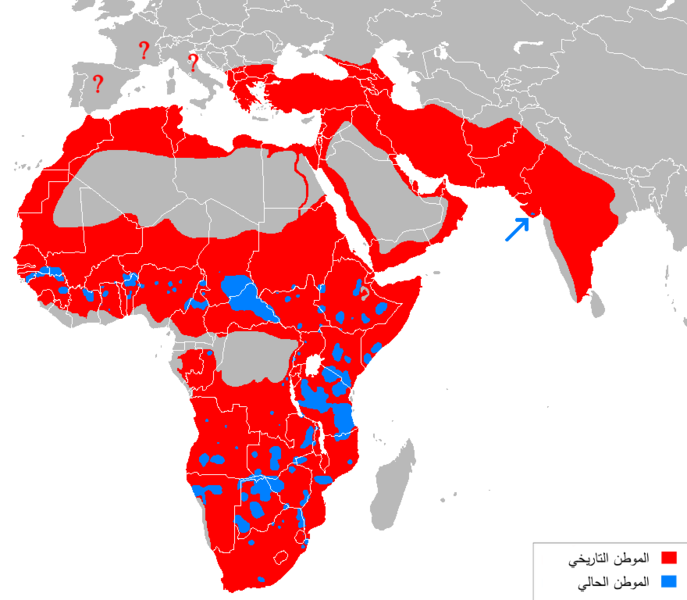
File:Lion distribution-ar.png

Original file (880 × 768 pixels, file size: 48 KB, MIME type: image/png)
Captions
Captions
Summary
[edit]| DescriptionLion distribution-ar.png |
العربية: خارطة تُظهر الموطن التاريخي للأسود باللون الأحمر، والحالي باللون الأزرق. |
| Date | (UTC) |
| Source |
This file was derived from: Lion distribution.png: |
| Author |
The original uploader was Tommyknocker at English Wikipedia.
|
| Other versions |
[edit]
|
| This is a retouched picture, which means that it has been digitally altered from its original version. Modifications: translated to Arabic. The original can be viewed here: Lion distribution.png:
|
Licensing
[edit]| Public domainPublic domainfalsefalse |
| |
This work has been released into the public domain by its author, Tommyknocker, at the English Wikipedia project. This applies worldwide. In case this is not legally possible: |
Original upload log
[edit]This image is a derivative work of the following images:
- File:Lion_distribution.png licensed with PD-user-w
- 2012-05-15T01:07:44Z Ras67 880x768 (34021 Bytes) cropped, optimized
- 2010-04-19T14:06:33Z MPF 882x770 (59991 Bytes) Change red/green to red/blue to avoid problems for viewers with red-green colourblindness
- 2010-01-11T20:00:28Z Tommyknocker 882x770 (44933 Bytes) Distribution in Southern Europe during historical times controversial, therefore now represented with question marks.
- 2009-11-02T17:01:51Z File Upload Bot (Magnus Manske) 882x770 (42518 Bytes) {{BotMoveToCommons|en.wikipedia|year={{subst:CURRENTYEAR}}|month={{subst:CURRENTMONTHNAME}}|day={{subst:CURRENTDAY}}}} {{Information |Description={{en|''no original description''}} |Source=Transferred from [http://en.wikiped
Uploaded with derivativeFX
File history
Click on a date/time to view the file as it appeared at that time.
| Date/Time | Thumbnail | Dimensions | User | Comment | |
|---|---|---|---|---|---|
| current | 11:44, 22 March 2018 |  | 880 × 768 (48 KB) | Maphobbyist (talk | contribs) | Check |
| 11:26, 22 March 2018 |  | 880 × 768 (48 KB) | Maphobbyist (talk | contribs) | South Sudan border | |
| 18:57, 31 July 2012 |  | 687 × 600 (180 KB) | باسم (talk | contribs) | == {{int:filedesc}} == {{Information |Description={{ar|خارطة تُظهر الموطن التاريخي للأسود باللون الأحمر، والحالي باللون الأزرق.}} |Source={{Derived from|Lion_distribution.png|display=50}} |D... |
You cannot overwrite this file.
File usage on Commons
The following 6 pages use this file:
File usage on other wikis
The following other wikis use this file:
- Usage on ar.wikipedia.org
Metadata
This file contains additional information such as Exif metadata which may have been added by the digital camera, scanner, or software program used to create or digitize it. If the file has been modified from its original state, some details such as the timestamp may not fully reflect those of the original file. The timestamp is only as accurate as the clock in the camera, and it may be completely wrong.
| Horizontal resolution | 37.8 dpc |
|---|---|
| Vertical resolution | 37.8 dpc |


