See also: Preferred usage guidelines | Blank infobox template page | Documentation page | Discussion page | Examples page
| This template may have no transclusions, because it is substituted by a tool or script, it is used as part of a short-term or less active Wikipedia process, or for some other reason. |
Please note: Infoboxes here may not meet current preferred usage guidelines and/or other unofficial conventions, and should not be relied upon as ideal infoboxes.
Colour schemes
edit
|
|
| ||||||||||||||||||||||||
|
|
| ||||||||||||
|
|
| ||||||||||||
|
|
| ||||||||||||||||
Basic types
editFreeway
editPacific Motorway F3 Freeway / Sydney–Newcastle Freeway / Sydney–Newcastle Expressway | |
|---|---|
| Coordinates | |
| General information | |
| Type | Motorway |
| Length | 127.1 km (79 mi) |
| Opened | 1963–98 |
| Gazetted | 1 February 2013[1][2] |
| Route number(s) |
|
| Former route number |
|
| Major junctions | |
| SSW end | |
| |
| NNE end |
|
| Location(s) | |
| Major suburbs / towns | |
| Highway system | |
{{Infobox Australian road
| type                     = Motorway
| road_name                = Pacific Motorway
| road_name2               = F3 Freeway / Sydney–Newcastle Freeway / Sydney–Newcastle Expressway
| state                    = nsw
| route                    =
*{{AUshield|NSW|M1}} M1
*<small>(Entire Length)</small>
| former                   =
*{{AUshield|N|1}} National Highway 1
*<small>(early 1980s-2013)</small>
*{{AUshield|Syd|F3}} F3
*<small>(1971-early 1980s)</small>
| image                    =
| image_upright            =
| caption                  =
| image_alt                =
| location                 =
| location_alt             =
| relief                   = 1
| coordinates_a            = {{coord|33|43|17.7|S|151|6|18.3|E|display=inline}}
| coordinates_b            = {{coord|32|48|55.3|S|151|38|3.9|E|display=inline}}
| pushpin_map_caption      =
| map_alt                  = Location map showing the endpoints of the road
| length                   = 127.1
| length_rnd               =
| length_ref               =
| direction_a              = SSW
| end_a                    =
* {{AUshield|NSW|A28}} [[Pennant Hills Road]] <small>(A28)</small>
* <small>[[Wahroonga]], [[New South Wales]]</small>
| exits                    =
* {{AUshield|Met|1}} [[Pacific Highway (Australia)|Pacific Highway]] <small>(Metroad 1)</small>
| direction_b              = NNE
| end_b                    =
* {{AUshield|R|1}}{{AUshield|S|132}} John Renshaw Drive <small>(National Route 1 / State Route 132)</small>
* Weakleys Drive
* <small>[[Beresfield]], [[New South Wales]]</small>
| est                      = 1963–98
| closed                   =
| gazetted                 = 1 February 2013
| gazetted_ref             = <ref>[http://www.nsw.gov.au/sites/default/files/Government-Gazette-1-February-2013.pdf Government Gazette of NSW 1 Feb 2013 Page 8], ''NSW Government'', Retrieved on 6 June 2013.</ref><ref>[http://www.nsw.gov.au/sites/default/files/Government-Gazette-10-May-2013.pdf Government Gazette of NSW 1 May 2013 Page 15], ''NSW Government'', Retrieved on 6 June 2013.</ref>
| maintained               =
| history                  =
| tourist                  =
| ring                     =
| split                    =
| tloop                    =
| region                   =
| lga                      =
| through                  =
* {{NSWcity|Berowra}}, {{NSWcity|Mount White}},
* {{NSWcity|Peats Ridge}}, {{NSWcity|Somersby}},
* {{NSWcity|Ourimbah}}, {{NSWcity|Tuggerah}},
* {{NSWcity|Warnervale}}, {{NSWcity|Mandalong}},
* {{NSWcity|Awaba}}, {{NSWcity|Minmi}}
| restrictions             =
| fuel                     =
| facilities               =
| show_links               = yes
}}
Highway
editGreat Eastern Highway | |
|---|---|
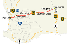 | |
Map of the south-west of Western Australia, with Great Eastern Highway highlighted in red | |
| General information | |
| Type | Highway |
| Length | 592.82 km (368 mi)[3] |
| Opened | 1860s |
| Gazetted | 14 April 1938[4] |
| Route number(s) |
|
| Tourist routes |
|
| Major junctions | |
| West end | |
| |
| East end | |
| Location(s) | |
| Major settlements | Perth, Northam, Merredin, Southern Cross, Coolgardie, Kalgoorlie |
| Highway system | |
{{Infobox Australian road
| type = highway
| state = wa
| road_name = Great Eastern Highway
| location = Great Eastern Highway route map.png
| location_alt = Map of major roads between Perth and Kalgoorlie
| loc_caption = Map of the south-west of Western Australia, with Great Eastern Highway highlighted in red
| length = 592.82
| length_ref = <ref name=RIMS />
| est = 1860s
| gazetted = 14 April 1938
| gazetted_ref = <ref name="gazetted 1938" />
| route =
* {{AUshield|N|94}} [[List of road routes in Western Australia#94|National Highway 94]] <small>(Victoria Park – Redcliffe, Midland – Coolgardie)</small>
* {{AUshield|R|ALT94}} [[List of road routes in Western Australia#A94|Alternate National Route 94]] <small>(Coolgardie – Kalgoorlie)</small>
* {{AUshield|R|1}} [[List of road routes in Western Australia#1|National Route 1]] <small>(Victoria Park – Woodbridge)</small>
* {{AUshield|S|51}} [[List of road routes in Western Australia#51|State Route 51]] <small>(Guildford – Midland)</small>
|tourist =
* [[File:Golden Pipeline Heritage Trail.svg|x25px|alt=Route marker]] [[Golden Pipeline Heritage Trail]] <small>(multiple locations)</small>
* {{AUshield|T|203|size=x25px}} [[List of road routes in Western Australia#203|Tourist Drive 203]] <small>(Guildford – Woodbridge)</small>
| direction_a = West
| end_a = {{AUshield|R|1|S|6}} [[Canning Highway]] <small>(National Route 1 / State Route 6)</small>
| exits =
* {{AUshield|S|30}} [[Albany Highway]] <small>(State Route 30)</small>
* {{AUshield|S|8}} [[Graham Farmer Freeway]] <small>(State Route 8)</small>
* {{AUshield|S|4}} [[Tonkin Highway]] <small>(State Route 4)</small>
* {{AUshield|N|94}} [[Great Eastern Highway Bypass]] <small>(National Highway 94)</small>
* {{AUshield|S|3}} [[Roe Highway]] <small>(State Route 3)</small>
* [[File:Pix.gif|21x20px|alt=|link=]] [[Great Southern Highway]]
* {{AUshield|S|120}} Northam-Toodyay Road <small>(State Route 120)</small>
* {{AUshield|S|115}} Northam-Pithara Road <small>(State Route 115)</small>
* {{AUshield|N|94}} [[Coolgardie-Esperance Highway]] <small>(National Highway 94)</small>
| direction_b = East
| end_b = {{AUshield|R|ALT94}} [[Goldfields Highway]] <small>(Alternate National Route 94), [[Kalgoorlie]]</small>
| through = [[Perth]], [[Northam, Western Australia|Northam]], [[Merredin]], [[Southern Cross, Western Australia|Southern Cross]], [[Coolgardie]], [[Kalgoorlie]]
| show_links = yes
}}
City highway
editRoad
editRural road
editStreet
editHunter Street | |
|---|---|
 | |
| Hunter Street from Civic railway station, To the right is the Newcastle Civic Theatre | |
| Coordinates | |
| General information | |
| Type | Street |
| Length | 3.4 km (2.1 mi) |
| Opened | Early 1800s |
| Maintained by | Newcastle City Council |
| Major junctions | |
| East end | Cnr Scott and Newcomen Streets, Newcastle |
| |
| West end | Selma St, Newcastle West |
| Location(s) | |
| Region | Hunter Region |
| LGA(s) | City of Newcastle |
| Suburb(s) | |
{{Infobox Australian road
| type                     = street
| road_name                = Hunter Street
| state                    = nsw
| image                    = HunterStCivic.jpg
| caption                  = Hunter Street from [[Civic railway station]], to the right is the [[Newcastle Civic Theatre]]
| coordinates_a            = {{coord|32|55|41.4|S|151|47|7.2|E|display=inline}}
| pushpin_label_position_a = left
| pushpin_map_caption      = Location of Hunter Street in New South Wales
| maintained               = [[City of Newcastle|Newcastle City Council]]
| length                   = 3.4
| direction_a              = East
| end_a                    = Cnr Scott and Newcomen Streets, Newcastle
| exits                    =
* Darby St
* Union St
* [[Pacific Highway (Australia)|Pacific Highway]]
* Tudor St
| direction_b              = West
| end_b                    = Selma St, Newcastle West
| est                      = Early 1800s
| region                   = Hunter Region
| lga                      = City of Newcastle
| through                  =
* [[Newcastle, New South Wales|Newcastle (suburb)]]
* [[Newcastle West, New South Wales|Newcastle West]]
}}
Track
editStrzelecki Track | |
|---|---|
| Coordinates | |
| General information | |
| Type | Track |
| Length | 459 km (285 mi) |
| Major junctions | |
| NE end | Adventure Way, Innamincka |
| SW end | Copley-Lyndhurst Road, Lyndhurst |
| Location(s) | |
| Region | Innamincka Recreation Reserve, Strzelecki Recreation Reserve |
| Restrictions | |
| Fuel supply | |
{{Infobox Australian road
| type                     = track
| road_name                = Strzelecki Track
| state                    = sa
| route_image              =
| image                    =
| image_upright            =
| caption                  =
| image_alt                =
| location                 =
| loc_caption              =
| location_alt             =
| relief                   =
| coordinates_a            = {{coord|27|44||S|140|44||E|display=inline}}
| coordinates_b            = {{coord|30|17||S|138|21||E|display=inline}}
| pushpin_map_caption      = Map showing the endpoints of the track
| map_alt                  = Map showing the NE and SW endpoints of the track
| length                   = 459
| length_ref               =
| direction_a              = NE
| end_a                    = Adventure Way,<br>[[Innamincka, South Australia|Innamincka]]
| exits                    =
| direction_b              = SW
| end_b                    = Copley-Lyndhurst Road,<br>[[Lyndhurst, South Australia|Lyndhurst]]
| est                      =
| closed                   =
| gazetted                 =
| gazetted_ref             =
| maintained               =
| history                  =
| route                    =
| region                   = Innamincka Recreation Reserve,<br>Strzelecki Recreation Reserve
| lga                      =
| through                  =
| restrictions             =
| permit                   =
| fuel                     =
* {{SAcity|Lyndhurst}},
* {{SAcity|Innamincka}},
* [[Cameron Corner, Queensland|Cameron Corner]]
| facilities               =
}}
Other types
editSplit road
editCapital Circle | |||
|---|---|---|---|
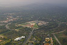 | |||
| Capital Circle is the inner of two circular concentric roads that orbit Parliament House. | |||
Location of Capital Circle in the Australian Capital Territory | |||
| Coordinates | |||
| General information | |||
| Type | Freeway | ||
| Length | 2.4 km (1.5 mi) | ||
| Ring road around | Capital Hill | ||
| Major junctions | |||
| |||
| North end |
| ||
| West end | |||
| |||
| West end | |||
| North end |
| ||
| Highway system | |||
| exits2 = | show_links = yes
{{Infobox Australian road
| type                     = freeway
| road_name                = Capital Circle
| state                    = act
| image                    = Parliament House Canberra (437594399).jpg
| image_upright            =
| caption                  = Capital Circle is the inner of two circular concentric roads that orbit [[Parliament House, Canberra|Parliament House]].
| image_alt                = Capital Circle is the inner of two circular concentric roads that orbit [[Parliament House, Canberra|Parliament House]].
| relief                   =
| coordinates_a            = {{coord|35|18|28.8|S|149|7|30|E|display=inline}}
| pushpin_map_caption      = Location of Capital Circle in the [[Australian Capital Territory]]
| map_alt                  = Location of Capital Circle in the [[Australian Capital Territory]]
| length                   = 2.4
| length_rnd               = 1
| length_ref               =
| ring                     = {{ACTcity|Capital Hill}}
| split                    = yes
| section1                 = North to West section
| direction_a1             = North
| end_a1                   =
*{{AUshield|ACT|A23}} [[Commonwealth Avenue, Canberra|Commonwealth Avenue]] <small>(A23)</small>
*<small>{{ACTcity|Capital Hill}} / {{ACTcity|Yarralumla}} / {{ACTcity|Parkes}}, [[Canberra]]</small>
| direction_b1             = West
| end_b1                   =
*[[Adelaide Avenue]]
*<small>{{ACTcity|Capital Hill}} / {{ACTcity|Deakin}} / {{ACTcity|Yarralumla}}, [[Canberra]]</small>
| exits1                   = {{AUshield|ACT|B23}} [[Canberra Avenue]] <small>(B23)</small>
| section2                 = West to North section
| direction_a2             = West
| end_a2                   =
*[[Adelaide Avenue]]
*<small>{{ACTcity|Capital Hill}} / {{ACTcity|Deakin}} / {{ACTcity|Yarralumla}}, [[Canberra]]</small>
| direction_b2             = North
| end_b2                   =
*{{AUshield|ACT|A23}} [[Commonwealth Avenue, Canberra|Commonwealth Avenue]] <small>(A23)</small>
*<small>{{ACTcity|Capital Hill}} / {{ACTcity|Yarralumla}} / {{ACTcity|Parkes}}, [[Canberra]]</small>
| exits2                   =
| show_links               = yes
}}
Ring road
editState Circle | |
|---|---|
 | |
| State Circle is the outer of two circular concentric roads that orbit Parliament House. | |
 | |
| General information | |
| Type | Road |
| Location | Canberra |
| Length | 3 km (1.9 mi) |
| Route number(s) |
|
| Former route number |
|
| Ring road around | Capital Hill |
| Tourist routes |
|
| Major junctions | |
| From | |
| |
| To | |
| Location(s) | |
| Major suburbs | Parkes, Barton, Forrest, Deakin, Yarralumla |
{{Infobox Australian road
| type                     = road
| road_name                = State Circle
| city                     = [[Canberra]]
| state                    = act
| image                    = Parliament House Canberra (437594399).jpg
| caption                  = State Circle is the outer of two circular concentric roads that orbit [[Parliament House, Canberra|Parliament House]].
| image_alt                = State Circle is the outer of two circular concentric roads that orbit Parliament House, Canberra.
| coordinates              = {{Coord|35|18|19.9|S|149|7|26|E|type:landmark_region:AU-ACT|display=inline}}
| length                   = 3
| length_rnd               = 1
| length_ref               =
| end_a                    = {{AUshield|ACT|A23}} [[Commonwealth Avenue, Canberra|Commonwealth Avenue]]
| end_b                    = {{AUshield|ACT|A23}} Commonwealth Avenue
| est                      =
| maintained               =
| route                    =
* {{AUshield|ACT|B23}} B23
* <small>(Entire length)</small>
| former                   =
* {{AUshield|R|23}} National Route 23
* <small>(19??-2013)</small>
| tourist                  =
* {{AUshield|ACTT|5}} ACT Tourist Drive 5
* {{AUshield|ACTT|6}} ACT Tourist Drive 6
* <small>(Various sections)</small>
| ring                     = {{ACTcity|Capital Hill}}
| exits                    =
* {{AUshield|none|NSW Large}} [[Kings Avenue, Canberra|Kings Avenue]]
* {{AUshield|ACT|B23}} [[Canberra Avenue]]
* {{AUshield|none|NSW Large}} Melbourne Avenue
* {{AUshield|none|NSW Large}} [[Adelaide Avenue]]
* {{AUshield|none|NSW Large}} Flynn Drive
| region                   =
| lga                      =
| through                  = {{ACTcity|Parkes|Barton|Forrest|Deakin}}, {{ACTcity|Yarralumla}}
}}
Locator map using alternative map
editStock Road | |
|---|---|
| Coordinates | |
| General information | |
| Type | Road |
| Length | 13.9 km (8.6 mi) |
| Route number(s) | (Leach Highway – Rockingham Road) |
| Major junctions | |
| North end | Page Street, Attadale |
| |
| South end | |
| Location(s) | |
| Major suburbs | Palmyra, O'Connor, Hamilton Hill, Bibra Lake, Spearwood |
{{Infobox Australian road
| type = road
| road_name = Stock Road
| state = wa
| alternative_location_map = Australia Western Australia metropolitan Perth
| coordinates_a = {{coord|32|1|2.6|S|115|47|31|E|display=inline}}
| coordinates_b = {{coord|32|8|13.7|S|115|47|22.4|E|display=inline}}
| pushpin_label_position_b = right
| length = 13.9
| direction_a = North
| end_a = Page Street, <small>[[Attadale, Western Australia|Attadale]]</small>
| exits =
* {{AUshield|S|6}} [[Canning Highway]] <small>(State Route 6)</small>
* {{AUshield|R|1|S|7}} [[Leach Highway]] <small>(National Route 1 / State Route 7)</small>
* {{AUshield|S|14}} Spearwood Avenue <small>(State Route 14)</small>
* Beeliar Drive
| direction_b = South
| end_b = {{AUshield|R|1}} [[Rockingham Road, Perth|Rockingham Road]] <small>(National Route 1), [[Munster, Western Australia|Munster]]</small>
| route = {{AUshield|R|1}} [[List of road routes in Western Australia#R1|National Route 1]]<br/><small>(Leach Highway – Rockingham Road)</small>
| through = [[Palmyra, Western Australia|Palmyra]], [[O'Connor, Western Australia|O'Connor]], [[Hamilton Hill, Western Australia|Hamilton Hill]], [[Bibra Lake]], {{WAcity|Spearwood}}
}}
Fictional road using all parameters
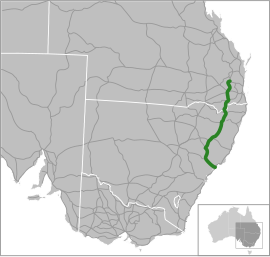
editSome Highway Another name –New South Wales | |||
|---|---|---|---|
| Monument commemorating the opening of a section of Thunderbolts Way | |||
 | |||
| Coordinates | |||
| General information | |||
| Type | Track (Under construction) | ||
| Length | 1,914 km (1,189.3045 mi)[5] | ||
| Opened | 1827 | ||
| Road closed | 2012 | ||
| Gazetted | 26 January 1788[6] | ||
| Maintained by | Transport for NSW | ||
| History | Originally a dirt track, first tarred in 1911, re-routed in 1947, closed in 2012 | ||
| Route number(s) | Yarraman – Warwick: Warwick – NSW/Qld Border: NSW/Qld Border – Newcastle: | ||
| Former route number | Former marker: (F3) | ||
| Tourist loop around | Some town | ||
| Tourist routes | (Vernon Circle to London Circuit)
(Vernon Circle to Barry Drive) | ||
| Major junctions | |||
| North end | |||
| South end | Newcastle, New South Wales | ||
| |||
| North end | a1 | ||
| Section 1 exits | |||
| South end | b1 | ||
| |||
| East end | a2 | ||
| Section 2 exits | |||
| West end | b2 | ||
| |||
| South end | a3 | ||
| Section 3 exits | |||
| North end | b3 | ||
| Location(s) | |||
| Region | Hunter Region | ||
| LGA(s) | |||
| via | Crows Nest, Toowoomba, Warwick, Tenterfield, Glen Innes, Armidale, Tamworth, Muswellbrook, Maitland | ||
| Restrictions | |||
| General | Snow chains required from July–September, 4WD only access during heavy rains | ||
| Permits | yes | ||
| Fuel supply | all you can drink | ||
| Facilities | very comfortable | ||
| Highway system | |||
{{Infobox Australian road
| type                     = track
| uc_former                = uc
| road_name                = Some Highway
| road_name2               = Another name
| state                    = qld
| state2                   = nsw
| route_image              = Australian National Route 1.svg
| image                    = Carsons Lookout 2.JPG
| image_upright            = 0.9
| caption                  = Monument commemorating the opening of a section of Thunderbolts Way
| image_alt                = alt text for image
| location                 = Location New England Hwy.svg
| loc_caption              =
| location_alt             = alt text for location
| alternative_location_map =
| force_national_map       = yes
| use_lga_map              =
| relief                   = yes
| coordinates              = {{coord|26|50|21|S|151|38|39|E|type:landmark_region:AU-QLD|display=inline,title}}
| coordinates_a            = {{coord|26|50|21|S|151|38|39|E|display=inline}}
| pushpin_label_position_a = left
| coordinates_b            = {{coord|32|45|41.3|S|151|44|38.6|E|display=inline}}
| pushpin_label_position_b = left
| pushpin_map_caption      = Some highway connects NSW to QLD
| map_alt                  = A moose once bit my sister
| maintained               = [[Transport for NSW]]
| length                   = 1914
| length_rnd               = 4
| length_ref               = <ref>length reference</ref>
| direction_a              = North
| end_a                    = [[Image:AQ3.png|35px]] [[Image:Australian Route 17.svg|25px]] '''[[D'Aguilar Highway]]''', [[Yarraman, Queensland]]
| exits                    = '''[[Image:AUSR85.png|25px]] [[Esk-Hampton Road]]<br />[[Image:AUHWYA2.png|35px]] [[Warrego Highway]]<br />[[Image:AUHWYA39.png|35px]] [[Image:AUSR85.png|25px]] [[Gore Highway]]<br />[[Image:AUHWYA15.png|35px]] [[Cunningham Highway]]<br />[[Image:Australian Route 44.svg|25px]] [[Bruxner Highway]]<br />[[Image:Australian Route 38.svg|25px]] [[Gwydir Highway]]<br />[[Image:Australian State Route 78.svg|25px]] [[Waterfall Way]]<br />[[Image:Australian Route 34.svg|25px]] [[Oxley Highway]]<br />[[Image:Australian State Route 95.svg|25px]] [[Fossickers Way]]<br />[[Image:Australian Route 34.svg|25px]] [[Oxley Highway]]<br />[[Image:Australian Route 37.svg|25px]] [[Kamilaroi Highway]]<br />[[Image:Australian State Route 69.svg|25px]] [[Putty Road]]<br />[[Image:Australian State Route 84.svg|25px]] [[Golden Highway]]'''
| direction_b              = South
| end_b                    = [[Image:Australian National Route 1.svg|25px]] '''[[Sydney–Newcastle Freeway]]''' /<br />[[Image:Australian Route 1.svg|25px]] '''[[Pacific Highway (Australia)|Pacific Highway]]''',<br />[[Newcastle, New South Wales]]
| est                      = 1827
| closed                   = 2012
| gazetted                 = 26 January 1788
| gazetted_ref             = <ref>The road was gazetted today.</ref>
| history                  = Originally a dirt track, first tarred in 1911, re-routed in 1947, closed in 2012
| route                    = ''Yarraman – Warwick:'' [[Image:AQ3.png|40px|center]] ''Formerly'' [[Image:Australian Route 42.svg|20px]]<br />''Warwick – NSW/Qld Border:'' [[Image:AUHWYA15.png|40px|center]] ''Formerly'' [[Image:Australian National Route 15.svg|20px]]<br />''NSW/Qld Border – Newcastle:'' [[Image:Australian National Route 15.svg|30px|center]]
| former                   = {{AUshield|NSW|M1}} <small>(M1)</small> marker to replace {{AUshield|N|1}} <small>(National Highway 1)</small><ref>[http://www.rta.nsw.gov.au/roadprojects/projects/alpha_numeric/index.html Alpha Numeric route numbers – A new Road Numbering System], [[Roads & Maritime Services]]. Retrieved 11 May 2013.</ref><br>Former marker: {{AUshield|Syd|F3}} <small>(F3)</small>
| tourist                  = {{AUshield|ACTT|1}} [[ACT Tourist Drive 1]]<br /><small>(Vernon Circle to London Circuit)</small><br />
{{AUshield|ACTT|4}} [[ACT Tourist Drive 4]]<br /><small>(Entire Length)</small><br />
{{AUshield|ACTT|7}} [[ACT Tourist Drive 7]]<br /><small>(Vernon Circle to Barry Drive)</small><br />
| ring                     =
| tloop                    = Some town
| split                    = Yes
| section1                 = First section
| direction_a1             = North
| end_a1                   = a1
| direction_b1             = South
| end_b1                   = b1
| exits1                   = Section 1 exits
| section2                 = Second section
| direction_a2             = East
| end_a2                   = a2
| direction_b2             = West
| end_b2                   = b2
| exits2                   = Section 2 exits
| section3                 = Third section
| direction_a3             = South
| end_a3                   = a3
| direction_b3             = North
| end_b3                   = b3
| exits3                   = Section 3 exits
| region                   = Hunter Region
| lga                      =
* [[City of Cessnock]]
* [[Dungog Shire]]
* [[Gloucester Shire]]
* [[Great Lakes Council]]
* [[City of Lake Macquarie]]
* [[City of Maitland]]
* [[Muswellbrook Shire]]
* [[City of Newcastle]]
* [[Port Stephens Council]]
* [[Singleton Council]]
* [[Upper Hunter Shire]]
| through                  = [[Crows Nest, Queensland|Crows Nest]], [[Toowoomba]], [[Warwick, Queensland|Warwick]], [[Tenterfield]], [[Glen Innes, New South Wales|Glen Innes]], [[Armidale]], [[Tamworth, New South Wales|Tamworth]], [[Muswellbrook]], [[Maitland, New South Wales|Maitland]]
| restrictions             = Snow chains required from July–September, 4WD only access during heavy rains
| permit                   = yes
| fuel                     = all you can drink
| facilities               = very comfortable
| show_links               = yes
| show_links2              = sa
}}
References
edit- ^ Government Gazette of NSW 1 Feb 2013 Page 8, NSW Government, Retrieved on 6 June 2013.
- ^ Government Gazette of NSW 1 May 2013 Page 15, NSW Government, Retrieved on 6 June 2013.
- ^ A ref
- ^ Another ref
- ^ length reference
- ^ The road was gazetted today.
- ^ Alpha Numeric route numbers – A new Road Numbering System, Roads & Maritime Services. Retrieved 11 May 2013.


