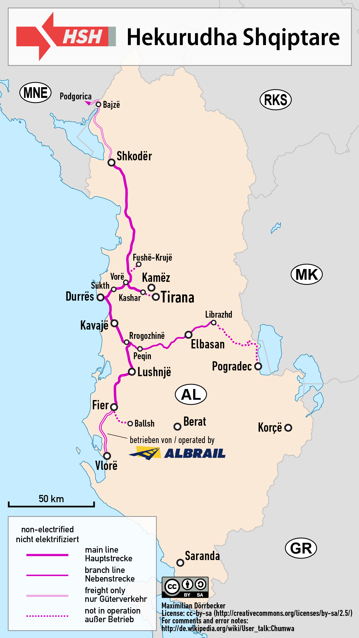
File:Railway map of Albania.png
Size of this preview: 338 × 600 pixels. Other resolutions: 135 × 240 pixels | 270 × 480 pixels | 432 × 768 pixels | 1,204 × 2,137 pixels.
Original file (1,204 × 2,137 pixels, file size: 248 KB, MIME type: image/png)
Captions
Captions
Add a one-line explanation of what this file represents
| Description |
|
| Date | see file history |
| Source |
Own work using:
|
| Author | Maximilian Dörrbecker (Chumwa) |
| Permission (Reusing this file) |
I, the copyright holder of this work, hereby publish it under the following license: This file is licensed under the Creative Commons Attribution-Share Alike 2.5 Generic license.
Sie dürfen das Bild zu den folgenden Bedingungen nutzen:
|
File history
Click on a date/time to view the file as it appeared at that time.
| Date/Time | Thumbnail | Dimensions | User | Comment | |
|---|---|---|---|---|---|
| current | 19:30, 22 April 2019 | | 1,204 × 2,137 (248 KB) | Chumwa (talk | contribs) | update |
| 20:36, 5 February 2019 |  | 1,204 × 2,137 (233 KB) | Chumwa (talk | contribs) | Aktualisierung | |
| 20:15, 22 June 2017 |  | 1,204 × 2,137 (235 KB) | Chumwa (talk | contribs) | corr | |
| 14:46, 18 June 2017 |  | 1,204 × 2,124 (225 KB) | Zenwort (talk | contribs) | Watermark cropped | |
| 04:46, 9 May 2017 |  | 1,204 × 2,235 (240 KB) | Chumwa (talk | contribs) | {{Information |Description= *{{de|Eisenbahnkarte von Albanien}} *{{en|Railway map of Albania}} |Source={{Own using}} *borders of Albania by {{U|Lencer}} *[http://www.bueker.net/trainspotting/map.php?file=maps/albania... |
You cannot overwrite this file.
File usage on Commons
The following 15 pages use this file:
- User:Chumwa/Gallery
- User:Chumwa/OgreBot/Potential transport maps/2017 June 11-20
- User:Chumwa/OgreBot/Potential transport maps/2017 June 21-30
- User:Chumwa/OgreBot/Potential transport maps/2017 May 1-10
- User:Chumwa/OgreBot/Potential transport maps/2019 February 1-9
- User:Chumwa/OgreBot/Transport Maps/2017 June 11-20
- User:Chumwa/OgreBot/Transport Maps/2017 June 21-30
- User:Chumwa/OgreBot/Transport Maps/2017 May 1-10
- User:Chumwa/OgreBot/Transport Maps/2019 February 1-9
- User:Chumwa/OgreBot/Travel and communication maps/2017 June 11-20
- User:Chumwa/OgreBot/Travel and communication maps/2017 June 21-30
- User:Chumwa/OgreBot/Travel and communication maps/2017 May 1-10
- User:Chumwa/OgreBot/Travel and communication maps/2019 February 1-9
- User:Chumwa/Railway maps
- Category:Hekurudha Shqiptare
File usage on other wikis
The following other wikis use this file:
- Usage on az.wikipedia.org
- Usage on bg.wikipedia.org
- Usage on cs.wikipedia.org
- Usage on de.wikipedia.org
- Usage on en.wikipedia.org
- Usage on es.wikipedia.org
- Usage on fa.wikipedia.org
- Usage on fi.wikipedia.org
- Usage on fr.wikipedia.org
- Usage on hu.wikipedia.org
- Usage on incubator.wikimedia.org
- Usage on it.wikipedia.org
- Usage on ja.wikipedia.org
- Usage on ko.wikipedia.org
- Usage on lv.wikipedia.org
- Usage on no.wikipedia.org
- Usage on pl.wikipedia.org
- Usage on pt.wikipedia.org
- Usage on ro.wikipedia.org
- Usage on ru.wikipedia.org
- Usage on sl.wikipedia.org
- Usage on sq.wikipedia.org
- Usage on sv.wikipedia.org
- Usage on tr.wikipedia.org
- Usage on uk.wikipedia.org
- Usage on www.wikidata.org
- Usage on zh.wikipedia.org