File:BihorSolnocCrasna Josephinische Landesaufnahme pg27-17.jpg
From Wikimedia Commons, the free media repository
Jump to navigation Jump to search

Original file (8,620 × 5,729 pixels, file size: 24.41 MB, MIME type: image/jpeg)

Captions

Captions

Add a one-line explanation of what this file represents
Name shown on the map
Nume din hartă
Administrative unit
Unitate administrativă
Romanian name
Numele românesc
Hungarian name
Numele unguresc
German name
Numele german
Country today
Ţara de astăzi
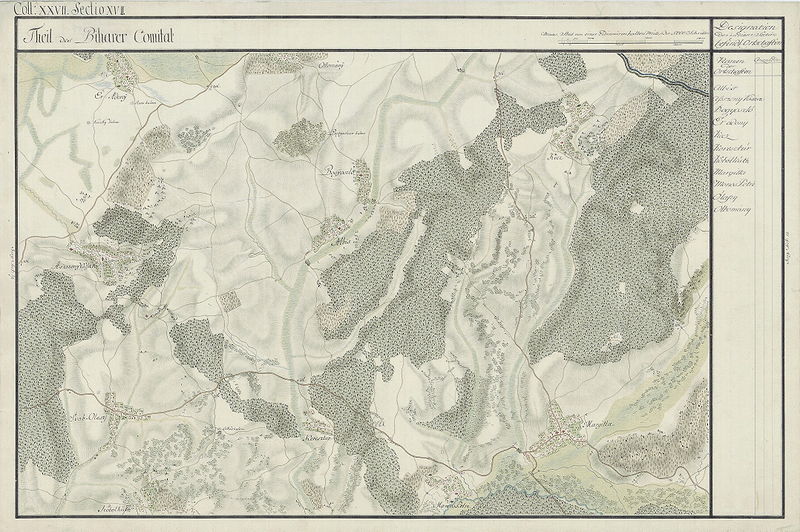
Albis Bihar Albiş Albis Romania
Asszony Vássára Bihar Târguşor [Asonvaşar] Asszonyvására Romania
Bogyoszló Bihar Buduslău [Bodişlău, Buduşlău] Érbogyoszló, Bogyoszló Romania
Ér-adony Bihar Adoni [Eriu-Adoni, Eriu-Adon] Éradony, Adony Romania
Kecz Bihar Cheţ Magyarkéc, Egyházaskéc, Kéc Romania
Keresztúr Bihar Crestur [Creştur, Cristur] Apátkeresztúr, Apátikeresztúr, Keresztúrapáti Romania
Köbelkúth Bihar Cubulcut [Chibelcut] Érköbölkút, Köbölkút Romania
Margitta Bihar Marghita mun. [Mărghita] Margitta Margareten Romania
Monos Petri Bihar Petreu [Petrău] Monospetri, Petri Romania
Ólaszy Bihar Olosig [Olosâg] Érolaszi, Svábolaszi, Olaszi Romania
Ottomány Bihar Otomani [Otoman] Ottomány Romania

Summary

[edit]
Description
English: Bihor County, 1782-85. Josephinische Landesaufnahme pg.27-17
Română: Harta Iosefină a Comitatului Bihor, 1782-85. Josephinische Landesaufnahme pg.27-17
Date between 1782 and 1785
date QS:P,+1782-00-00T00:00:00Z/8,P1319,+1782-00-00T00:00:00Z/9,P1326,+1785-00-00T00:00:00Z/9
Source Österreichisches Staatsarchiv, Kriegsarchiv
Author Historische Militärkarte der österreichisch-ungarischen Monarchie
Permission
(Reusing this file)
Public domain

This work is in the public domain in its country of origin and other countries and areas where the copyright term is the author's life plus 100 years or fewer.


You must also include a United States public domain tag to indicate why this work is in the public domain in the United States.
This file has been identified as being free of known restrictions under copyright law, including all related and neighboring rights.

Clickable Map of the Bihor, Solnoc, Crasna County

[edit]
Kingdom of Hungary counties(clickable map)RomaniaGrand Duchy Of Transylvania(Clickable map)Page 22-21: Püspökladány, SzerepPage 22-22: SzerepPage 23-18: BalmazújvárosPage 23-19: HajdúszoboszlóPage 23-20: Hajdúszoboszló, Kaba, NádudvarPage 23-21: Báránd, Bihardancsháza, Földes, Sáp, Sárrétudvari, TetétlenPage 23-22: Bihardancsháza, Biharnagybajom, Bihartorda, NagyrábéPage 23-23: Darvas, 	Füzesgyarmat, Szeghalom, VekerdPage 23-24: Okány, VésztőPage 23-25: SarkadkeresztúrPage 23-26: Doboz, ŞărcadPage 24-18: BerekböszörményPage 24-19: DebrecenPage 24-20: Derecske, Hajdúszovát, Mikepércs, SárándPage 24-21: Berettyóújfalu, Szentpéterszeg, TépePage 24-22: Bakonszeg, Berettyóújfalu, Berettyószentmárton, Furta, Mezőpeterd, Váncsod, ZsákaPage 24-23: Komádi, Körösszakál, Körösszegapáti, Magyarhomorog, MezősasPage 24-24: Ateaş, Biharugra, Komádi, ZsadányPage 24-25: Geszt, MezőgyánPage 24-26: Ciumeghiu, Kötegyán, MicherechiPage 24-27: Avram Iancu, Mişca, ZerindPage 25-16: Balkány, Bököny, Geszteréd, Hajdúhadház, Nyíradony, Szakoly, TéglásPage 25-17: HajdúsámsonPage 25-18: VámospércsPage 25-19: Hajdúbagos, Hosszúpályi, Leta Mare, MonostorpályiPage 25-20: Cetariu, Gáborján, Hencida, Kismarja, Konyár, Pocsaj, TămăşeuPage 25-21: Ártánd, Bedő, Biharkeresztes, Bojt, Borş, Nagykereki, VáncsodPage 25-22: Berekböszörmény, Borş, Darvas, Girişu de Criş, Körösnagyharsány, Sântandrei, ToboliuPage 25-23: Cefa, Gepiu, Nojorid, Sânnicolau RomânPage 25-24: Husasău de Tinca, Mădăras, Salonta, Tinca, TulcaPage 25-25: BatărPage 25-26: Apateu, Mişca, ŞepreuşPage 26-17: Nyíracsád, PenészlekPage 26-18: Bagamér, Şimian, Vámospércs, Valea lui MihaiPage 26-19: Álmosd, Ciuhoi, Cherechiu, Leta Mare, Săcueni, ŞimianPage 26-20: Ciuhoi, Diosig, Roşiori, Săcueni, Sălard, TămăşeuPage 26-21: Biharia, Cetariu, Paleu, SârbiPage 26-22: Copăcel, Ineu, Oradea, Oşorhei, Paleu, Săcădat, SânmartinPage 26-23: Copăcel, Drăgeşti, Hidişelu de Sus, Lăzăreni, Oşorhei, Nojorid, Sânmartin,Page 26-24: Hidişelu de Sus, Holod, Husasău de Tinca, Lăzăreni, Sâmbăta, TincaPage 26-25: Căpâlna, Cociuba Mare, Olcea, Pocola, Şoimi, TincaPage 26-26: Craiva, Hăşmaş, Lunca, Olcea, ŞoimiPage 26-27: Archiş, Cărand, Beliu, Hăşmaş, TârnovaPage 26-28: Bârsa, Bocsig, Seleuş, ŞilindiaPage 27-15: Penészlek, Petreşti, Pişcolt, SanislăuPage 27-16: Andrid, Curtuișeni, Sălacea, TarceaPage 27-17: Abrămuţ, Buduslău, Cherechiu, Marghita, Săcueni, Sălacea, TarceaPage 27-18: Abram, Chişlaz, Ciuhoi, Derna, Săcueni, Spinuş, TăuteuPage 27-19: Brusturi, Derna, Sârbi, Spinuş, TileagdPage 27-20: Aştileu, Copăcel, Ineu, Lugașu de Jos, Săcădat, Sânmartin, Tileagd, ŢeţcheaPage 27-21: Câmpani, Ceica, Copăcel, Drăgeşti, VârciorogPage 27-22: Câmpani, Ceica, Dobreşti, Drăgeşti, Holod, Pomezeu, Răbăgani, Sâmbăta, SpinuşPage 27-23: Beiuș, Căbeşti, Căpâlna, Finiş, Holod, Pocola, Răbăgani, Remetea, Şoimi, Uileacu de BeiuşPage 27-24: Finiş, Şoimi, TărcaiaPage 27-25: Archiş, Dezna, Igneşti, Moneasa, SebişPage 28-17: Abram, MarghitaPage 28-18: Abram, Balc, Popeşti, Suplacu de Barcău, TăuteuPage 28-19: Popeşti, Suplacu de BarcăuPage 28-20: Aleșd, Aștileu, Auşeu, Borod, Măgeşti, Vadu CrişuluiPage 28-21: Bratca, Măgeşti, Şuncuiuş, Vadu CrişuluiPage 28-22: Bratca, Căbeşti, RoşiaPage 28-23: Budureasa, Căbeşti, Curăţele, Drăgăneşti, RemeteaPage 28-24:Page 28-25: Cărpinet, Câmpani, Criştioru de Jos, Lunca, Ştei, VaşcăuPage 28-26: Cărpinet, Dezna, Dieci, GurahonţPage 29-20:Page 29-21:Page 29-22:Page 29-23:Page 29-24:Page 29-25:Page 29-26:RO/HU/DE/LegendArad County(Clickable map)Original maps of the Kingdom of Hungary
Josephinische Landesaufnahme. Senzitive map of the Bihor/Solnoc/Crasna County, 1782-1785. (Click on the desired quadrant)---->Under construction

File history

Click on a date/time to view the file as it appeared at that time.

Date/TimeThumbnailDimensionsUserComment
current06:17, 13 April 2010Thumbnail for version as of 06:17, 13 April 20108,620 × 5,729 (24.41 MB)Asybaris01 (talk | contribs){{Information |Description={{ro|1=sdew}} |Source=dsff |Author=edfgg |Date=12 |Permission= |other_versions= }} Category:Josephinische Landaufnahme

There are no pages that use this file.

File usage on other wikis

The following other wikis use this file:

  • Usage on de.wikipedia.org
  • Usage on ro.wikipedia.org

Metadata