File:C. 1453 France.jpg
Jump to navigation
Jump to search

Size of this preview: 727 × 599 pixels. Other resolutions: 291 × 240 pixels | 582 × 480 pixels | 932 × 768 pixels | 1,242 × 1,024 pixels | 1,458 × 1,202 pixels.
Original file (1,458 × 1,202 pixels, file size: 1.55 MB, MIME type: image/jpeg)
Captions
Captions
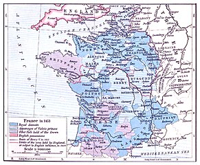
France circa 1453 CE
Summary
[edit]
| Description |
English: Map of France circa 1453 CE Deutsch: Karte von Frankreich circa 1453 u.Z. Español: Mapa de Francia circa 1453 EC Français : Carte de la France environ 1453 EC Italiano: Mappa della Francia circa 1453 EC |
| Date | (Original map c. 1911) |
| Source | Digitally-enhanced derivative of a public domain map by William R. Shepherd (1871-1934), Professor of History at Columbia University in New York and cartographer, published in "Historical Atlas" (Henry Holt & Co., NY 1911), original map available from the Perry-Castañeda Library Map Collection of the University of Texas at Austin. |
| Author | Ty's Commons |
Licensing
[edit]
I, the copyright holder of this work, hereby publish it under the following license:
This file is licensed under the Creative Commons Attribution-Share Alike 4.0 International license.
- You are free:
- to share – to copy, distribute and transmit the work
- to remix – to adapt the work
- Under the following conditions:
- attribution – You must give appropriate credit, provide a link to the license, and indicate if changes were made. You may do so in any reasonable manner, but not in any way that suggests the licensor endorses you or your use.
- share alike – If you remix, transform, or build upon the material, you must distribute your contributions under the same or compatible license as the original.
[[Category:Maps of the history of Lorraine]
File history
Click on a date/time to view the file as it appeared at that time.
| Date/Time | Thumbnail | Dimensions | User | Comment | |
|---|---|---|---|---|---|
| current | 08:57, 10 August 2024 | | 1,458 × 1,202 (1.55 MB) | Ty's Commons (talk | contribs) | Secondary image |
| 09:59, 24 July 2024 |  | 1,410 × 1,154 (1.24 MB) | Ty's Commons (talk | contribs) | Uploaded own work with UploadWizard |
You cannot overwrite this file.
File usage on Commons
There are no pages that use this file.
Metadata
Categories:
- Maps of the kingdom of France
- Maps of the history of France
- Territorial evolution of France
- History of Angoulême
- County of Anjou
- Armagnac (province)
- History of Artois
- History of Aquitaine
- Maps of Aquitaine
- County of Auvergne
- History of Béarn
- Bigorre
- County of Blois
- History of Bourbonnais
- History of Bourgogne
- Maps of the history of Bretagne
- County of Burgundy
- History of Franche-Comté
- Duchy of Burgundy
- History of Cahors
- History of Calais
- County of Champagne
- Maps of the history of Champagne
- History of Dauphiné
- Maps of Dauphiné
- Forez
- Maps of French Flanders
- History of French Flanders
- Maps of the history of Flanders
- Maps of the history of Foix
- Maps of Gascogne
- History of Guyenne
- History of Languedoc
- History of Limoges
- History of Limousin
- Lyon in the 15th century
- Maine (province)
- Marche (province)
- History of Narbonne
- History of Normandy
- Maps of the history of Occitania
- Périgord
- History of Picardie
- History of Poitou
- History of Provence
- History of Rodez
- History of Saintonge
- County of Toulouse
- History of Touraine