File:Syrian, Iraqi, and Lebanese insurgencies.png

Original file (4,509 × 3,449 pixels, file size: 1.74 MB, MIME type: image/png)
Captions
Captions
Summary

|
This file may be updated to reflect new information. If you wish to use a specific version of the file without it being overwritten, please upload the required version as a separate file. |
| Description |
Map of the Syrian Civil War, the Iraq Civil War (2014–present), and the Lebanese insurgency. For previous revisions of the battle map (not including Lebanon) before June 2015, see File:Syria and Iraq 2014-onward War map.png. After updating this map, please also update the date(s) at w:Module:Iraq Syria map date, used to denote the date in articles. Areas under joint SDF-SAA control
In the respective colours: |
||||
| Date | |||||
| Source |
Own work w:en:Template:Syrian, Iraqi, and Lebanese insurgencies detailed map |
||||
| Author | BlueHypercane761 | ||||
| Other versions |
Note: Comments "areas of activity" means that this is not territorial control is shown.
|


|
This historical map image could be re-created using vector graphics as an SVG file. This has several advantages; see Commons:Media for cleanup for more information. If an SVG form of this image is available, please upload it and afterwards replace this template with
{{vector version available|new image name}}.
It is recommended to name the SVG file “Syrian, Iraqi, and Lebanese insurgencies.svg”—then the template Vector version available (or Vva) does not need the new image name parameter. |

|
This image has a useful history, which can be viewed as an animation. |
Licensing
- You are free:
- to share – to copy, distribute and transmit the work
- to remix – to adapt the work
- Under the following conditions:
- attribution – You must give appropriate credit, provide a link to the license, and indicate if changes were made. You may do so in any reasonable manner, but not in any way that suggests the licensor endorses you or your use.
- share alike – If you remix, transform, or build upon the material, you must distribute your contributions under the same or compatible license as the original.
File history
Click on a date/time to view the file as it appeared at that time.
| Date/Time | Thumbnail | Dimensions | User | Comment | |
|---|---|---|---|---|---|
| current | 11:43, 6 September 2020 | | 4,509 × 3,449 (1.74 MB) | LyriaSiders (talk | contribs) | Reports that the SAA have taken over the Doubayat oil and gas field and surrounding area from ISIL elements. Now there is apparently no more hard control by ISIL in the central desert. |
| 15:10, 24 May 2020 |  | 4,509 × 3,449 (2.21 MB) | Wiz9999 (talk | contribs) | Updating Revolutionary Commando Army & US presence colour to teal. | |
| 11:27, 7 March 2020 |  | 4,509 × 3,449 (1.74 MB) | Nate Hooper (talk | contribs) | Update after the Turkish response. Also, see the discussion page for a further update I have planned. | |
| 03:23, 19 February 2020 |  | 4,509 × 3,449 (1.75 MB) | Nate Hooper (talk | contribs) | Update after the Idlib offensive. | |
| 23:45, 7 February 2020 |  | 4,509 × 3,449 (1.75 MB) | The Dolly Parton Challenge - Still more country than Alan Jackson (talk | contribs) | Further SAA advances towards Idlib. | |
| 23:26, 7 February 2020 |  | 4,509 × 3,449 (2.51 MB) | The Dolly Parton Challenge - Still more country than Alan Jackson (talk | contribs) | Reverted to version as of 00:25, 6 February 2020 (UTC) Never mind | |
| 00:32, 6 February 2020 | 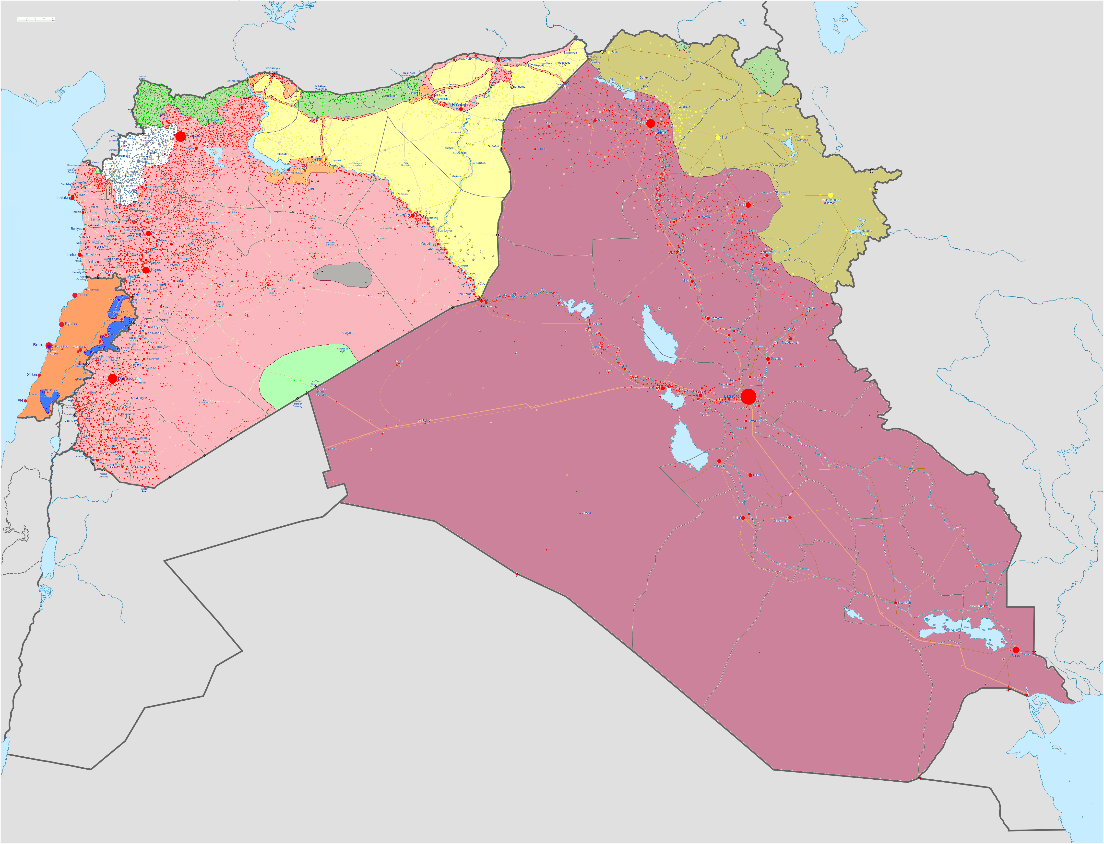 | 4,509 × 3,449 (2.51 MB) | TheHatingNerdino666 (talk | contribs) | Fixed the Manbij area. | |
| 00:25, 6 February 2020 |  | 4,509 × 3,449 (2.51 MB) | TheHatingNerdino666 (talk | contribs) | Big update as the Syrian Army continues the push towards Idlib. | |
| 17:05, 7 January 2020 |  | 4,509 × 3,449 (2.27 MB) | Nate Hooper (talk | contribs) | Wew, it's been a while (I was a way for a bit because I was banned, but I appealed and was successful). Anyway, the SAA have made advances in Idlib. | |
| 17:05, 27 October 2019 |  | 4,509 × 3,449 (2.51 MB) | Mlpwtfisthat Backup 7.0 (talk | contribs) | Remove the date. |
You cannot overwrite this file.
File usage on Commons
More than 100 pages use this file. The following list shows the first 100 pages that use this file only. A full list is available.
- User:Hermes79
- User:Hermes7979
- User:Magog the Ogre/Maps of conflicts/2015 August
- User:Magog the Ogre/Maps of conflicts/2015 December
- User:Magog the Ogre/Maps of conflicts/2015 July
- User:Magog the Ogre/Maps of conflicts/2015 June
- User:Magog the Ogre/Maps of conflicts/2015 November
- User:Magog the Ogre/Maps of conflicts/2015 October
- User:Magog the Ogre/Maps of conflicts/2015 September
- User:Magog the Ogre/Maps of conflicts/2016 April
- User:Magog the Ogre/Maps of conflicts/2016 August
- User:Magog the Ogre/Maps of conflicts/2016 February
- User:Magog the Ogre/Maps of conflicts/2016 January
- User:Magog the Ogre/Maps of conflicts/2016 July
- User:Magog the Ogre/Maps of conflicts/2016 June
- User:Magog the Ogre/Maps of conflicts/2016 March
- User:Magog the Ogre/Maps of conflicts/2016 May
- User:Magog the Ogre/Maps of conflicts/2016 November
- User:Magog the Ogre/Maps of conflicts/2016 October
- User:Magog the Ogre/Maps of conflicts/2016 September
- User:RobiH
- User talk:BlueHypercane761
- File:2013 Hama Offensive.svg
- File:2015 Latakia Frontlines.svg
- File:26032019Syrian, Iraqi, and Lebanese insurgencies.png (file redirect)
- File:Aleppo Offensives 2015.svg
- File:Aleppo offensive (October 2013).svg
- File:Attaques-terroristes-meurtrières-au-21eme-siecle.png
- File:Battle of Daraa City.svg
- File:Battle of Hasakah.svg
- File:Battle of Qamishli.svg
- File:Battle of Raqqa.svg
- File:Battle of Tadmur.svg
- File:Battle of Western Qalamoun.svg
- File:Battlefields in The Global War on Terror.svg
- File:Battlefields in The Global War on Terror - edit03.png
- File:Battlefields in The Global War on Terror - edit04.png
- File:Benghazi Conflict Detailed Map.png
- File:Benghazi Conflict Detailed Map.svg
- File:Boko Haram insurgency map.svg
- File:Countries by soldier count.svg
- File:Deir ez-Zor clashes (2017).svg
- File:Derna Conflict Detailed Map.png
- File:East Congo conflict map.svg
- File:GSPC map.png
- File:ISIS (Grey) Territory Change 2014-2016.gif
- File:Iraqi Civil War map (2014–present).png
- File:Islamist insurgency in Nigeria.svg
- File:Lebanese insurgency.svg
- File:Libyan Civil War.svg
- File:Libyan war final-fr.svg
- File:Map of Ongoing conflicts around the world.png
- File:Map of terror of the Islamic State (ad-Daula al-islāmiyya).png
- File:Mexico states map small war.PNG
- File:Mosul offensive (2015) map.png
- File:Number of Terrorist Incidents.png
- File:Ongoing Conflicts (1).png
- File:Pakistan-Waziristan-Map.png
- File:Political map Afar triangle.png
- File:Rif Damashq.svg
- File:Siege of Homs Map.svg
- File:Sinai insurgency.svg
- File:SituationSyriaIraqLebanon05092020.png (file redirect)
- File:Somali Civil War (2009-present).svg
- File:Syria and Iraq 2014-onward War map.png
- File:Syrian, Iraqi, and Lebanese insurgencies.png
- File:Syrian Civil War map.svg
- File:Syrian civil war.png
- File:Tadmur offensive (2015).jpg
- File:Yemeni Civil War.svg
- Template:City maps of ongoing civil wars
- Category:Aleppo
- Category:Attack
- Category:Battle of Aleppo
- Category:Battles in 2016
- Category:Battles of Syria
- Category:Battles of the Syrian Civil War
- Category:Cities in Syria
- Category:Civil wars
- Category:Conflicts
- Category:Conflicts by continent
- Category:Conflicts by country
- Category:Conflicts by type
- Category:Feuds
- Category:Fights
- Category:Liberation of Palmyra (2016)
- Category:Maps of Aleppo
- Category:Maps of Somali Civil War
- Category:Maps of conflicts
- Category:Maps of disputed territories
- Category:Maps of the Syrian Civil War in 2016
- Category:Military conflicts
- Category:Ongoing armed conflicts
- Category:Quarrels
- Category:Rebellions
- Category:Riots
- Category:Schisms
- Category:Syrian Civil War
- Category:Terrorism
- Category:Uprisings
View more links to this file.
File usage on other wikis
The following other wikis use this file:
- Usage on ar.wikipedia.org
- Usage on arz.wikipedia.org
- Usage on de.wikipedia.org
- Usage on en.wikipedia.org
- Template talk:Lebanese insurgency detailed map
- Module talk:Syrian, Iraqi, and Lebanese insurgencies detailed map
- Module talk:Syrian and Iraqi insurgency detailed map/Archive 1
- Module talk:Iraqi insurgency detailed map/Archive 4
- Talk:Control of cities during the Syrian civil war/Archive 49
- User:AH bharara/sandbox/Islamic State of Iraq and the Levant affiliated Groups
- Talk:Islamic State/Archive 38
- Wikipedia:Graphics Lab/Map workshop/Archive/2016
- Talk:Islamic State/Archive 40
- Talk:Battle of Mosul (2016–2017)/Archive 1
- Talk:Islamic State/Archive 41
- User:KaldeFakta68/sandbox
- User:Edisonabcd/sandbox
- Usage on fa.wikipedia.org
- Usage on id.wikipedia.org
- Usage on ku.wikipedia.org
- Usage on mi.wikipedia.org
- Usage on pt.wikinews.org
- Usage on tr.wikipedia.org
- Usage on www.wikidata.org
- Usage on zh.wikipedia.org
Metadata
- Maps of Islamic State of Iraq and the Levant
- Current civil wars maps
- Maps of the Syrian Civil War
- Maps of the Syrian Civil War in 2018
- Maps of the Syrian Civil War in 2017
- Maps of the Syrian Civil War in 2016
- Maps of the Syrian Civil War in 2015
- Maps of the Iraqi Civil War (2014–2017)
- Maps of Lebanon
- Maps of Iraqi Kurdistan
- Maps of Syrian Kurdistan
- Conflicts in 2018
- Conflicts in 2017
- Conflicts in 2016
- Conflicts in 2015
- 2017 in Iraq
- 2016 in Iraq
- 2015 in Iraq
- 2017 in politics of Lebanon
- 2016 in Lebanon
- 2015 in Lebanon