Bollinger Canyon Creek is an 6.72 mile long (10.8 km) stream in Contra Costa County, California in the San Francisco Bay Area. It is a tributary of San Ramon Creek, which is part of the Walnut Creek watershed.
| Bollinger Canyon Creek Bollinger Creek | |
|---|---|
 Upper Bollinger Canyon Creek shaded by mature California Bay and Coast live oak in Las Trampas Regional Wilderness (December 19th, 2021) | |
| Location | |
| Country | United States |
| State | California |
| Region | Bay Area |
| District | Contra Costa County |
| Physical characteristics | |
| Mouth | San Ramon Creek |
| Length | ~6.76 miles |
| Basin features | |
| River system | Walnut Creek Watershed |
| Cities | San Ramon, CA |
Course
Bollinger Canyon Creek begins as a number of ephemeral streams that emit from steep gulches in the high north–south trending valley formed between Rocky Ridge and Las Trampas Ridge in the Berkeley Hills near the city of San Ramon, California. The highest point in the drainage is around 2,000 feet above sea level. From a low divide which separates it with Las Trampas Creek, it runs southward through Bollinger Canyon gradually descending in altitude until abruptly turning to the east near Crow Canyon Road in San Ramon, California. Shortly after, it is confined to concrete channels and it joins with San Ramon Creek near the city's downtown.

-
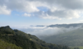 Fog rolling up Bollinger Canyon to the divide between Bollinger Creek and Las Trampas Creek (December 19, 2021)
 -
 A healthy stretch of Bollinger Creek flanked by California mixed evergreen forest (December 19, 2021)
This article has not been added to any content categories. Please help out by adding categories to it so that it can be listed with similar articles. (November 2023) |