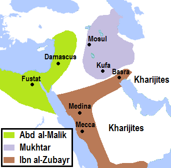
2nd_Fitna_Territorial_control.png (342 × 337 pixels, file size: 25 KB, MIME type: image/png)
File history
Click on a date/time to view the file as it appeared at that time.
| Date/Time | Thumbnail | Dimensions | User | Comment | |
|---|---|---|---|---|---|
| current | 21:03, 28 May 2019 |  | 342 × 337 (25 KB) | AhmadLX | city name correction, borders updated |
| 19:49, 26 May 2019 |  | 342 × 337 (25 KB) | AhmadLX | boundaries based on better sources | |
| 18:56, 25 March 2019 |  | 352 × 324 (36 KB) | AhmadLX | Higher resolution. | |
| 19:51, 12 February 2019 |  | 191 × 156 (15 KB) | AhmadLX | User created page with UploadWizard |
File usage
The following 3 pages use this file:
Global file usage
The following other wikis use this file:
- Usage on af.wikipedia.org
- Usage on id.wikipedia.org
- Pengguna:HaEr48
- Wikipedia:Artikel pilihan/Jadwal/Usulan/2020
- Wikipedia:Artikel pilihan/Jadwal/Usulan/2020/Periode 9
- Wikipedia:Artikel pilihan/Daftar artikel pilihan 2020
- Wikipedia:Artikel Pilihan/35 2020
- Wikipedia:Arsip halaman utama/2020/08/24
- Wikipedia:Arsip halaman utama/2020/08/25
- Wikipedia:Arsip halaman utama/2020/08/26
- Wikipedia:Arsip halaman utama/2020/08/27
- Wikipedia:Arsip halaman utama/2020/08/28
- Wikipedia:Arsip halaman utama/2020/08/29
- Wikipedia:Arsip halaman utama/2020/08/30
