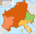
File:Carolingian empire 828.svg

Original file (SVG file, nominally 1,091 × 1,053 pixels, file size: 348 KB)

Summary

Description
Español: Imperio carolingio en 828 antes de las guerras civiles.
Date
Source

Own work

  • [1] Sur l'epoque de la désunion de la Septimanie de Royaume de Aquitaine, & de son érection en Duché, & sur l'acte de partage que fit l'an 817, l'empereur Luis-le-Débonaire de ses Etats entre ses fils.
  • [2] Pepin continued to hold Aquitaine; but the realm sustained various alterations in boundary: only a portion of Septimania, which had hitherto been conjoined with Aquitaine, was retained by him, namely the county of Carcassonne. On the north, the frontier was also somewhat contracted, but the loss was compensated by a dismemberment of Cisjurane Burgundy, three counties -Autun, towering in Roman magnificence: smiling Nevers, and dreary Avalon, where every stone appears stamped with vestiges of once animated nature.
  • [3]: At the Aachen assembly in February 828, Louis the Pious blamed the loss of Lower Pannonia on Balderic of Friuli's "cowardice". Louis the Pious therefore revoked Balderic's honors and divided the match of Friuli into four separate counties: Carantania, Carniola, Istria, and a now greatly reduced Friuli. [...] The province of Carantania at this time passed into the control of the Bavarian king and his eastern prefect. [...] Louis could justify the annexation of Carantania on the basis of the Ordenatio imperii which explicitly included Carantania as part of his Bavarian kingdom. But as the ruler of Italy, Lothar had cotrolled Friuli (including Carantania) since 817. Balderic's downfall in 828 and the resulting Bavarian annexation of Carantania therefore represented Louis's first agressive move against his eldest brother.
  • [4]: Pippin, another son of Lewis, had dominion in Aquitaine and Gascony.
  • [5]: En 817, en Aquisgram, se hizo división entre los hijos de Luis el Piadoso: y Lotario fue asociado al Imperio; Pepino obtuvo la Gascuña y la Aquitania con los territorios de Nevers, Autun, Avallen en la Borgoña.
  • [6]: Pepin continued to hold Aquitaine; but the realm sustained various alterations in boundary : only a portion of Septimania, which had hitherto been conjoined with Aquitaine, was retained by him, namely the county of Carcassonne. On the north, the frontier was also somewhat contracted, but the loss was compensated by a dismemberment of Cisjurane Burgundy, three counties— Autun, towering in Roman magnificence : smiling Nevers, and dreary Avalon, where every stone appears stamped with vestiges of once animated nature.
Author Trasamundo
Other versions

Licensing

I, the copyright holder of this work, hereby publish it under the following licenses:
GNU head Permission is granted to copy, distribute and/or modify this document under the terms of the GNU Free Documentation License, Version 1.2 or any later version published by the Free Software Foundation; with no Invariant Sections, no Front-Cover Texts, and no Back-Cover Texts. A copy of the license is included in the section entitled GNU Free Documentation License.
w:en:Creative Commons
attribution share alike
This file is licensed under the Creative Commons Attribution-Share Alike 3.0 Unported, 2.5 Generic, 2.0 Generic and 1.0 Generic license.
You are free:
  • to share – to copy, distribute and transmit the work
  • to remix – to adapt the work
Under the following conditions:
  • attribution – You must give appropriate credit, provide a link to the license, and indicate if changes were made. You may do so in any reasonable manner, but not in any way that suggests the licensor endorses you or your use.
  • share alike – If you remix, transform, or build upon the material, you must distribute your contributions under the same or compatible license as the original.
You may select the license of your choice.

Captions

Add a one-line explanation of what this file represents

Items portrayed in this file

depicts

13 March 2010

image/svg+xml

6908994735cabc5747629f33d2b509c07bfe85f3

356,703 byte

1,053 pixel

1,091 pixel

File history

Click on a date/time to view the file as it appeared at that time.

Date/TimeThumbnailDimensionsUserComment
current12:09, 28 October 2021Thumbnail for version as of 12:09, 28 October 20211,091 × 1,053 (348 KB)RowanwindwhistlerLighter colours, fake text added for better rendering in articles (real text is now hidden).
08:34, 4 May 2016Thumbnail for version as of 08:34, 4 May 20161,091 × 1,053 (251 KB)RowanwindwhistlerSofter colours form http://colorbrewer2.org/
21:38, 22 April 2016Thumbnail for version as of 21:38, 22 April 20161,091 × 1,053 (251 KB)RowanwindwhistlerClear shapes, some colours from https://en.wikipedia.org/wiki/Wikipedia:WikiProject_Maps/Conventions
18:30, 13 March 2010Thumbnail for version as of 18:30, 13 March 20101,091 × 1,053 (940 KB)Trasamundolegend
18:26, 13 March 2010Thumbnail for version as of 18:26, 13 March 20101,091 × 1,053 (940 KB)Trasamundo{{Information |Description={{es|1=Imperio carolingio en 828 antes de las guerras civiles.}} |Source={{own}} |Author=Trasamundo |Date=13 March 2010 |Permission= |other_versions= }} Category:Maps of the Carolingian Empire

Global file usage

The following other wikis use this file:

Metadata