

Al-Bahah Province: Difference between revisions
No edit summary |
Added fact that 4 of the 9-11 hijackers were recruited from this region. |
||
| (44 intermediate revisions by 32 users not shown) | |||
| Line 1: | Line 1: | ||
| ⚫ | |||
| ⚫ | |||
{{short description|Administrative region of Saudi Arabia}} |
{{short description|Administrative region of Saudi Arabia}} |
||
| ⚫ | |||
| ⚫ | |||
{{Infobox settlement |
{{Infobox settlement |
||
| name |
| name = Al-Bahah |
||
| native_name |
| native_name = Al-Bāḥah <br /> {{lang|ar|ٱلْبَاحَة}} |
||
| native_name_lang |
| native_name_lang = ar |
||
| official_name |
| official_name = |
||
| settlement_type |
| settlement_type = [[Regions of Saudi Arabia|State]] |
||
| image_skyline |
| image_skyline = منظر من بلاد قبيلة حوالة3.jpeg |
||
| imagesize |
| imagesize = |
||
| image_alt |
| image_alt = |
||
| image_caption |
| image_caption = A view from the country of the Hawalah tribe, showing the eastern side of Mount Atherb overlooking the [[Tihamah]] |
||
| image_flag |
| image_flag = |
||
| flag_size |
| flag_size = |
||
| flag_alt |
| flag_alt = |
||
| image_shield |
| image_shield = |
||
| shield_size |
| shield_size = |
||
| shield_alt |
| shield_alt = |
||
| image_map |
| image_map = Al Bahah in Saudi Arabia.svg |
||
| mapsize |
| mapsize = |
||
| map_alt |
| map_alt = |
||
| map_caption |
| map_caption = Map of Saudi Arabia with Al-Bahah highlighted |
||
| coordinates |
| coordinates = {{Coord|20|0|N|41|30|E|display=title}} |
||
| coor_pinpoint |
| coor_pinpoint = |
||
| subdivision_type = Country |
|||
| seat_type = [[Capital (political)|Capital]] |
|||
| |
| subdivision_name = {{flag|Saudi Arabia}} |
||
| |
| seat_type = [[Capital (political)|Capital]] |
||
| |
| seat = [[Al Bahah|Al-Bahah]] |
||
| |
| parts_type = [[Mintaqah|''Manatiq'' (Districts)]] |
||
| |
| parts_style = para |
||
| |
| p1 = 7 |
||
| |
| area_total_km2 = 9921 |
||
| |
| area_footnotes = |
||
| |
| population_as_of = 2017 census |
||
| |
| population_footnotes = |
||
| |
| population_total = 476172 |
||
| |
| population_note = |
||
| population_blank1_title = |
|||
| ⚫ | |||
| |
| population_blank1 = |
||
| ⚫ | |||
| ⚫ | |||
| |
| population_blank2 = |
||
| ⚫ | |||
| ⚫ | |||
| |
| demographics1_name1 = |
||
| |
| demographics1_info1 = |
||
| |
| demographics_type2 = |
||
| |
| demographics2_name1 = |
||
| |
| demographics2_info1 = |
||
| |
| demographics2_name2 = |
||
| |
| demographics2_info2 = |
||
| |
| demographics2_name3 = |
||
| |
| demographics2_info3 = |
||
| |
| blank1_name_sec1 = |
||
| |
| blank1_info_sec1 = |
||
| |
| blank2_name_sec1 = |
||
| |
| blank2_info_sec1 = |
||
| |
| blank_name_sec2 = |
||
| |
| blank_info_sec2 = |
||
| |
| blank1_name_sec2 = |
||
| |
| blank1_info_sec2 = |
||
| |
| blank2_name_sec2 = |
||
| |
| blank2_info_sec2 = |
||
| |
| postal_code_type = [[ISO 3166-2:SA|ISO 3166-2]] |
||
| |
| postal_code = 11 |
||
| area_code = +966 17 |
|||
| leader_name = [[[[Hussam_bin_Saud_bin_Abdulaziz_Al_Saud|Hussam bin Saud|Prince Hussam bin Saud]]]] |
|||
| |
| leader_title = Governor |
||
| |
| leader_name = [[Hussam bin Saud Al Saud]] |
||
| |
| leader_party = |
||
| website = {{URL|https://www.albaha.gov.sa}} |
|||
| ⚫ | |||
}} |
}} |
||
{{Coord|20|0|N|41|30|E|display=title}} |
|||
'''Al-Bahah |
'''Al-Bahah Province''' ({{Lang-ar|ٱلْبَاحَة}} ''{{transl|ar|ALA|al-Bāḥah}}'' {{IPA|ar|alˈbaːħa|pron}}) is a [[provinces of Saudi Arabia|province of Saudi Arabia]]. It is located in the southwestern part of the [[Hejaz]]i region. It has an area of 9,921 km<sup>2</sup>, and a population of 476,172 (2017).<ref>{{Cite web|url=https://www.stats.gov.sa/sites/default/files/population_characteristics_surveysar.pdf|title=Population Characteristics surveys|date=2017|website=The General Authority for Statistics}}</ref> Its capital is [[Al Bahah]].<ref>{{Cite web|url=https://www.stats.gov.sa/ar/photo-album/11|title=معلومات عامة عن مناطق المملكة العربية السعودية|website=General Authority of statistics|date=25 February 2016 }}</ref> The region includes Al-Baḥah City, Al-Mikhwah and Baljorashi. Baljorashi has a famous traditional market known as ''Sūq as-Sabt'' ({{lang|ar|سُوْق ٱلسَّبْت}}), which translates to English as "Saturday market". The Baljorashi market is very old and its exact age is unknown. Other cities in the region include Baljourashi, Al-Mikhwah, Rahwat Albar and Sabt Alalaya. Al-Baḥah region is the home of two [[Azd]] tribes, the [[Ghamid]] and the [[Zahran tribe|Zahran]].<ref>{{cite book |last=Cuddihy |first=Kathy |title=An A to Z of Places and Things Saudi |page=6 |location=[[London]], the [[United Kingdom|U.K.]] |publisher=[[Stacey International]] |year=2001 |isbn=978-1-9009-8840-7}}</ref> |
||
Four of the muscle hijackers - the operatives who would storm the cockpits and control the passengers - involved in the [[September 11 attacks]] were recruited from three towns in the Al-Bahah region.<ref>{{Cite web |title=National Commission on Terrorist Attacks Upon the United States |url=https://govinfo.library.unt.edu/911/report/911Report_Ch7.htm |access-date=2024-09-13 |website=govinfo.library.unt.edu}}</ref> |
|||
==Etymology== |
==Etymology== |
||
The word ''al-Baḥah'' (or ''Baḥah'' without ''al'' which is equivalent to "the" in English) has many meanings; it means water<ref>{{Cite web|url=https://www.almaany.com/ar/dict/ar-ar/%D8%A8%D8%A7%D8%AD%D8%A9/|title=تعريف و معنى باحة بالعربي في معجم المعاني الجامع، المعجم الوسيط ،اللغة العربية المعاصر |
The word ''al-Baḥah'' (or ''Baḥah'' without ''al'' which is equivalent to "the" in English) has many meanings; it means water<ref>{{Cite web |url=https://www.almaany.com/ar/dict/ar-ar/%D8%A8%D8%A7%D8%AD%D8%A9/ |title=تعريف و معنى باحة بالعربي في معجم المعاني الجامع، المعجم الوسيط ،اللغة العربية المعاصر - معجم عربي عربي - صفحة 1 |last=Team |first=Almaany |website=www.almaany.com |language=ar |access-date=2018-11-22}}</ref> and the maximum of it, the courtyard of a house, the high and abundant palm tree. In tales it refers to an extremely deep bottomless well in al-Zafir fortress. It means "open space", "water" and "abundant palm tree" and the "midline of a road". |
||
==Governors== |
==Governors== |
||
* |
* [[Saud bin Abdulrahman bin Turki Al Sudairi]] (1962–1977) |
||
* |
* [[Ibrahim bin Abdulaziz Al Ibrahim]] (1977–1987) |
||
* |
* [[Muhammed bin Saud Al Saud]] (1987–2010) |
||
* [[Mishari bin Saud bin Abdulaziz]] (28 August 2010 – 22 April 2017) |
|||
* [[Hussam bin Saud bin Abdulaziz Al Saud]] (22 April 2017 – present) |
|||
==Geography== |
==Geography== |
||
[[File:Hawalah 6400.png|thumb|Jabal Atherb ({{lang|ar|جَبَل أَثرْب}})]] |
|||
| ⚫ | Al-Baḥah is the name of the province as well its main city, situated in the northwestern part of Ghamed territory. The region is formed of [[Hijaz mountains|mountains]], hills, plains, valleys and desert stretches. This region is situated in the |
||
| ⚫ | Al-Baḥah is the name of the province as well its main city, situated in the northwestern part of Ghamed territory. The region is formed of [[Hijaz mountains|mountains]], [[Shadah Al-asfal|hills]], plains, valleys and desert stretches. This region is situated in the Hejaz, between longitudes 41/42 E and latitudes 19/20 N. The region covers an area about 36,000 km<sup>2</sup>. |
||
===Major cities=== |
===Major cities=== |
||
* [[Al Bahah]] |
* [[Al Bahah]] |
||
* [[Baljurashi]] |
* [[Baljurashi]] |
||
* Al-Mandaq |
|||
* [[Almandaq]] |
|||
* Al-Mikhwah |
|||
* [[Almikhwah]] |
|||
* Al-Aqeeq |
|||
* [[Alaqeeq]] |
|||
==Topography== |
==Topography== |
||
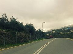
[[File:الباحة - 2.jpeg|thumb|Clouds next to the [[Sarawat Mountains|Sarat Mountains]]]] |
|||
<!-- Unsourced image removed: [[File:Albaha3.jpg|thumb|200px|right|Al-Sarat]] --> |
|||
The region is divided by huge rocky steeps into two main sectors. To the west is a coastal plain, [[Tihamah]]. |
The region is divided by huge rocky steeps into two main sectors. To the west is a coastal plain, the [[Tihamah]]. To the east is the mountain range of al-[[Sarawat Mountains|''As-Sarawat'' or the Sarat]], with an elevation of {{convert|1,500|to|2,450|m|ft|abbr=on}} above sea level. |
||
==Population== |
==Population== |
||
A genealogist{{who|date=December 2010}} has confirmed that the majority of the population of Al-Baḥah are descended from the Azad Shenou`a tribe which emigrated from the south of the Hejaz in the [[Arabian |
A genealogist{{who|date=December 2010}} has confirmed that the majority of the population of Al-Baḥah are descended from the Azad Shenou`a tribe which emigrated from the south of the Hejaz in the [[Arabian Peninsula]], following some historical natural events. |
||
Al-Azad is an Arab tribe which is divided into 24 tribes derived from four stocks: Azad Shenou`a, Azad Al Sarat, Azad Ghassan and Azad Aman. Al-Azad (or al-Assad the [[Arabian lion|Lion]]) was the title given to Darda`e bin al-Ghot bin Nabt bin Malik bin Nassr al-Azad. Kaab bin al-Harith had seven children including Ghamed, who is Amr bin Abdullah bin Kaab. Zahran bin al-Harith had six children, including Abdullah bin Zahran who is the great grandfather of the Zahran tribe. The population of the region now is about 500,000. Many have moved to major metropolitan areas for better living and education. |
Al-Azad is an Arab tribe which is divided into 24 tribes derived from four stocks: Azad Shenou`a, Azad Al Sarat, Azad Ghassan and Azad Aman. Al-Azad (or al-Assad the [[Arabian lion|Lion]]) was the title given to Darda`e bin al-Ghot bin Nabt bin Malik bin Nassr al-Azad. Kaab bin al-Harith had seven children including Ghamed, who is Amr bin Abdullah bin Kaab. Zahran bin al-Harith had six children, including Abdullah bin Zahran who is the great grandfather of the Zahran tribe. The population of the region now is about 500,000. Many have moved to major metropolitan areas for better living and education. |
||
==Climate== |
==Climate== |
||
The variation in topography influences the climate of the region. Al-Sarat area is exposed to the formation of clouds and fog, and this often happens in winter because of air masses coming from the [[Red Sea]], accompanied by thunderstorms. In spring and summer the climate is mild and pleasant. The climate in the area of the Tihamah is different from that in Al-Sarat, although they are separated by no more than {{convert|25|km|mile|abbr=in}}. Tihama is an undulating coastal plain, hot in summer, warm in spring and mild in winter. The climate in general falls in the arid zone. Relative humidity varies between 52% and 67%, with maximum temperatures of {{convert|23|°C|°F|abbr=on}}, and minimum temperatures of {{convert|12|°C|°F|abbr=on}}. |
The variation in topography influences the climate of the region. Al-Sarat area is exposed to the formation of clouds and fog, and this often happens in winter because of air masses coming from the [[Red Sea]], accompanied by thunderstorms. In spring and summer the climate is mild and pleasant. The climate in the area of the Tihamah is different from that in Al-Sarat, although they are separated by no more than {{convert|25|km|mile|abbr=in}}. The Tihama is an undulating coastal plain, hot in summer, warm in spring and mild in winter. The climate in general falls in the arid zone. Relative humidity varies between 52% and 67%, with maximum temperatures of {{convert|23|°C|°F|abbr=on}}, and minimum temperatures of {{convert|12|°C|°F|abbr=on}}. |
||
| ⚫ | |||
| ⚫ | |||
File:Al-Baha City.jpg|Al-Bahah City |
|||
File:Thee Ain 2023.jpg|[[Thee Ain]] historic village |
|||
File:Sarawat Mountains, Baha Region, Saudi Arabia (15).jpg|[[Sarawat Mountains]] in Al-Bahah |
|||
File:Mount Shada.jpg|Mount Shada |
|||
| ⚫ | |||
| ⚫ | |||
File:Al-hoson.jpg|Awirah Village Fort |
|||
| ⚫ | |||
| ⚫ | |||
==Social structure== |
==Social structure== |
||
The social life of the inhabitants of the region is based on [[Sunni]] [[Islam]], in addition to the well established Arab customs and tradition. Each tribe division or subdivision has its own ''[[ |
The social life of the inhabitants of the region is based on [[Sunni]] [[Islam]], in addition to the well established Arab customs and tradition. Each tribe division or subdivision has its own ''[[Sheikh|Shaykh]]'' (head). |
||
{{Geographic location |
{{Geographic location |
||
|Centre = Al Bahah |
|Centre = Al Bahah Province |
||
|North = [[Makkah |
|North = [[Makkah Province]] |
||
|Northeast = |
|Northeast = |
||
|East = [[ |
|East = [[ʽAsir Province]] |
||
|Southeast = |
|Southeast = |
||
|South = [[Makkah |
|South = [[Makkah Province]] |
||
|Southwest = |
|Southwest = |
||
|West = [[Makkah |
|West = [[Makkah Province]] |
||
|Northwest = |
|Northwest = |
||
}} |
}} |
||
| ⚫ | |||
| ⚫ | |||
File:Baha-old-architecture.jpg |
|||
File:منظر من بلاد قبيلة حوالة3.jpeg |
|||
File:الباحة - 2.jpeg |
|||
Hawalah 6400.png| |
|||
File:Shada Chingrir Jhiri.JPG|[[وادي نيرا]] |
|||
| ⚫ | |||
| ⚫ | |||
| ⚫ | |||
| ⚫ | |||
==See also== |
==See also== |
||
* [[Middle East]] |
* [[Middle East]] |
||
** [[Arabian Peninsula]] |
|||
*** [[Sarawat Mountains|Sarat Mountains]] |
|||
*** [[South Arabia]] |
|||
==References== |
==References== |
||
| Line 138: | Line 149: | ||
{{Saudi Arabia topics}} |
{{Saudi Arabia topics}} |
||
{{Authority control}} |
|||
| ⚫ | |||
| ⚫ | |||
[[Category:Provinces of Saudi Arabia]] |
[[Category:Provinces of Saudi Arabia]] |
||
Latest revision as of 19:57, 13 September 2024
This article relies largely or entirely on a single source. (September 2014) |
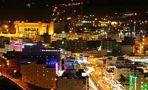
Al-Bahah
Al-Bāḥah ٱلْبَاحَة | |
|---|---|
 A view from the country of the Hawalah tribe, showing the eastern side of Mount Atherb overlooking the Tihamah | |
 Map of Saudi Arabia with Al-Bahah highlighted | |
| Coordinates: 20°0′N 41°30′E / 20.000°N 41.500°E | |
| Country | |
| Capital | Al-Bahah |
| Manatiq (Districts) | 7 |
| Government | |
| • Governor | Hussam bin Saud Al Saud |
| Area | |
| • Total | 9,921 km2 (3,831 sq mi) |
| Population (2017 census) | |
| • Total | 476,172 |
| • Density | 48/km2 (120/sq mi) |
| ISO 3166-2 | 11 |
| Area code | +966 17 |
| Website | www |
Al-Bahah Province (Arabic: ٱلْبَاحَة al-Bāḥah pronounced [alˈbaːħa]) is a province of Saudi Arabia. It is located in the southwestern part of the Hejazi region. It has an area of 9,921 km2, and a population of 476,172 (2017).[1] Its capital is Al Bahah.[2] The region includes Al-Baḥah City, Al-Mikhwah and Baljorashi. Baljorashi has a famous traditional market known as Sūq as-Sabt (سُوْق ٱلسَّبْت), which translates to English as "Saturday market". The Baljorashi market is very old and its exact age is unknown. Other cities in the region include Baljourashi, Al-Mikhwah, Rahwat Albar and Sabt Alalaya. Al-Baḥah region is the home of two Azd tribes, the Ghamid and the Zahran.[3]
Four of the muscle hijackers - the operatives who would storm the cockpits and control the passengers - involved in the September 11 attacks were recruited from three towns in the Al-Bahah region.[4]
Etymology
[edit]The word al-Baḥah (or Baḥah without al which is equivalent to "the" in English) has many meanings; it means water[5] and the maximum of it, the courtyard of a house, the high and abundant palm tree. In tales it refers to an extremely deep bottomless well in al-Zafir fortress. It means "open space", "water" and "abundant palm tree" and the "midline of a road".
Governors
[edit]- Saud bin Abdulrahman bin Turki Al Sudairi (1962–1977)
- Ibrahim bin Abdulaziz Al Ibrahim (1977–1987)
- Muhammed bin Saud Al Saud (1987–2010)
- Mishari bin Saud bin Abdulaziz (28 August 2010 – 22 April 2017)
- Hussam bin Saud bin Abdulaziz Al Saud (22 April 2017 – present)
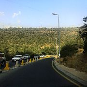
Geography
[edit]
Al-Baḥah is the name of the province as well its main city, situated in the northwestern part of Ghamed territory. The region is formed of mountains, hills, plains, valleys and desert stretches. This region is situated in the Hejaz, between longitudes 41/42 E and latitudes 19/20 N. The region covers an area about 36,000 km2.
Major cities
[edit]- Al Bahah
- Baljurashi
- Al-Mandaq
- Al-Mikhwah
- Al-Aqeeq
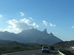
Topography
[edit]
The region is divided by huge rocky steeps into two main sectors. To the west is a coastal plain, the Tihamah. To the east is the mountain range of al-As-Sarawat or the Sarat, with an elevation of 1,500 to 2,450 m (4,920 to 8,040 ft) above sea level.
Population
[edit]A genealogist[who?] has confirmed that the majority of the population of Al-Baḥah are descended from the Azad Shenou`a tribe which emigrated from the south of the Hejaz in the Arabian Peninsula, following some historical natural events.
Al-Azad is an Arab tribe which is divided into 24 tribes derived from four stocks: Azad Shenou`a, Azad Al Sarat, Azad Ghassan and Azad Aman. Al-Azad (or al-Assad the Lion) was the title given to Darda`e bin al-Ghot bin Nabt bin Malik bin Nassr al-Azad. Kaab bin al-Harith had seven children including Ghamed, who is Amr bin Abdullah bin Kaab. Zahran bin al-Harith had six children, including Abdullah bin Zahran who is the great grandfather of the Zahran tribe. The population of the region now is about 500,000. Many have moved to major metropolitan areas for better living and education.
Climate
[edit]The variation in topography influences the climate of the region. Al-Sarat area is exposed to the formation of clouds and fog, and this often happens in winter because of air masses coming from the Red Sea, accompanied by thunderstorms. In spring and summer the climate is mild and pleasant. The climate in the area of the Tihamah is different from that in Al-Sarat, although they are separated by no more than 25 km (16 miles). The Tihama is an undulating coastal plain, hot in summer, warm in spring and mild in winter. The climate in general falls in the arid zone. Relative humidity varies between 52% and 67%, with maximum temperatures of 23 °C (73 °F), and minimum temperatures of 12 °C (54 °F).
Gallery
[edit]-
 Al-Bahah City
 -
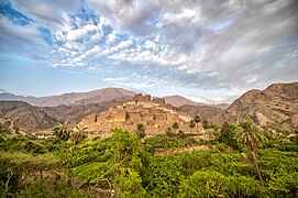 Thee Ain historic village
 -
 Sarawat Mountains in Al-Bahah
 -
 Mount Shada
 -
-
-
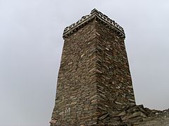 Awirah Village Fort
 -


Social structure
[edit]The social life of the inhabitants of the region is based on Sunni Islam, in addition to the well established Arab customs and tradition. Each tribe division or subdivision has its own Shaykh (head).
Places adjacent to Al-Bahah Province | ||||||||||||||||
|---|---|---|---|---|---|---|---|---|---|---|---|---|---|---|---|---|
| ||||||||||||||||
See also
[edit]References
[edit]- ^ "Population Characteristics surveys" (PDF). The General Authority for Statistics. 2017.
- ^ "معلومات عامة عن مناطق المملكة العربية السعودية". General Authority of statistics. 25 February 2016.
- ^ Cuddihy, Kathy (2001). An A to Z of Places and Things Saudi. London, the U.K.: Stacey International. p. 6. ISBN 978-1-9009-8840-7.
- ^ "National Commission on Terrorist Attacks Upon the United States". govinfo.library.unt.edu. Retrieved 13 September 2024.
- ^ Team, Almaany. "تعريف و معنى باحة بالعربي في معجم المعاني الجامع، المعجم الوسيط ،اللغة العربية المعاصر - معجم عربي عربي - صفحة 1". www.almaany.com (in Arabic). Retrieved 22 November 2018.

| International | |
|---|---|
| National | |