

Dez Dam: Difference between revisions
No edit summary |
Adding short description: "Dam in Khuzestan, Iran", overriding automatically generated description |
||
| (223 intermediate revisions by more than 100 users not shown) | |||
| Line 1: | Line 1: | ||
{{Short description|Dam in Khuzestan, Iran}} |
|||
{{Infobox_Dam |
|||
{{Infobox dam |
|||
|dam_name= Dez Dam |
|||
| name = Dez Dam |
|||
|[[Image:Dez dam.jpg|thumb|]] |
|||
| name_official = Dez<br />({{lang-fa|دز}}) |
|||
|caption= Dez Dam |
|||
| image = |
|||
|official_name= Dez Dam |
|||
| image_size = |
|||
|crosses= [[Dez River]] |
|||
| image_caption = |
|||
|reservoir= |
|||
| image_alt = |
|||
|locale=[[Khuzestan]]-[[Iran]] |
|||
| location_map = Iran |
|||
|City=[[andimeshk]]-[[Iran]] |
|||
| location_map_size = |
|||
|maint= <small>Iran Water & Power Resources Development Co.</small> |
|||
| location_map_caption = |
|||
|length= 212 m |
|||
| coordinates = {{coord|32|36.3|N|48|27.8|E|type:landmark_region:IR|display=inline,title}} |
|||
|height= 203 m |
|||
| country = [[Iran]] |
|||
|width= 27 m |
|||
| location = [[Khuzestan]] |
|||
|began= 1959 |
|||
| status = O |
|||
|open= 1963 |
|||
| construction_began = 1959 |
|||
|closed= |
|||
| opening = 1963 |
|||
|cost= |
|||
| demolished = |
|||
|reservoir_capacity= 3,340 million m<sup>3</sup> |
|||
| cost = |
|||
|reservoir_catchment= |
|||
| owner = Khuzestan Water & Power Authority |
|||
|reservoir_surface= 56 km² |
|||
| dam_type = [[Arch dam]] |
|||
|turbines= 8 <ref>http://www.khpimc.com/sample-project.htm</ref> |
|||
| dam_height = {{convert|203|m|ft|0|abbr=on}} |
|||
|installed_capacity= 520 MW <ref>http://www.khpimc.com/sample-project.htm</ref> |
|||
| dam_length = {{convert|380|m|ft|0|abbr=on}} |
|||
|max_capacity= |
|||
| dam_width_crest = {{convert|27|m|ft|0|abbr=on}} |
|||
|annual_generation= 1,783 GWh <ref>http://www.khpimc.com/sample-project.htm</ref> |
|||
| dam_width_base = |
|||
|bridge_carries= |
|||
| dam_volume = 3460 MCM |
|||
|bridge_width= |
|||
| dam_crosses = [[Dez River]] |
|||
|bridge_clearance= |
|||
| spillway_count = |
|||
|bridge_traffic= |
|||
| spillway_type = |
|||
|bridge_toll= |
|||
| spillway_capacity = {{convert|6000|m3/s|abbr=on}}<ref>{{Cite web|url=https://www.dezdam.co.ir/107/index.aspx|title=Dam and Reservoir Specification|website=Dez Dam Powerplant O&M Company|language=fa}}</ref> |
|||
|bridge_id= |
|||
| res_name = |
|||
|map_cue= |
|||
| res_capacity_total = {{convert|3.34|km3|acre.ft|abbr=on}} |
|||
|map_image= |
|||
| res_catchment = |
|||
|map_text= |
|||
| res_surface = {{convert|64.9|km2|sqmi|abbr=on}}<ref name="first_ref"/> |
|||
|map_width= |
|||
| res_max_depth = |
|||
|coordinates= {{coord|32|36.3|N|48|27.8|E|type:landmark_region:IR|display=inline,title}} |
|||
| res_tidal_range = |
|||
|lat= |
|||
| plant_operator = |
|||
|long= |
|||
| plant_commission = 1962-1970 |
|||
|extra= |
|||
| plant_decommission = |
|||
| plant_type = |
|||
| plant_turbines = 8 x 65 MW<ref name="first_ref">{{cite web |url=http://www.khpimc.com/sample-project.htm |title= New Page 1|website=www.khpimc.com |archive-url=https://web.archive.org/web/20110713145427/http://www.khpimc.com/sample-project.htm |archive-date=July 13, 2011}}</ref> |
|||
| plant_capacity = 520 MW<ref name="first_ref"/> |
|||
| plant_annual_gen = 1,783 GWh<ref name="first_ref"/> |
|||
| website = {{URL|dezdam.co.ir}} |
|||
| extra = |
|||
}} |
}} |
||
The '''Dez Dam''' ({{lang-fa|سد دز}}), formerly known as '''Mohammad-Reza Shah Pahlavi Dam''' (Persian: {{lang|fa|سد محمدرضا شاه پهلوی}}), before [[1979 Revolution]], is an [[arch dam]] on the [[Dez River]] in the southwestern province of [[Khuzestan]], [[Iran]]. It was built between 1959 and 1963 during the rule of [[Mohammad Reza Pahlavi]], the last [[Shah]] of Iran, with contacting an Italian consortium and is owned by the Khuzestan Water & Power Authority.<ref name="Britannica Dez Dam">{{cite web |title=Britannica Dez Dam |url=https://www.britannica.com/topic/Dez-Dam |website=britannica}}</ref> The dam is {{convert|203|m|ft}} high, making it one of the highest in the country, and has a reservoir capacity of {{Convert|3340000000|m3|acre.ft|abbr=on}}. At the time of construction the Dez Dam was [[Iran]]'s biggest development project. The primary purpose of the dam is [[hydroelectric]] power production and [[irrigation]]. It has an associated 520 MW power station and its reservoir helps irrigate up to {{Convert|80500|ha|acre|abbr=on}} of farmland. US$42 million of the cost to construct the dam came from the [[World Bank]].<ref name=indust>{{cite web|title=Hydroelectric Power Plants in Iran|url=http://www.industcards.com/hydro-iran.htm|publisher=IndustCards|access-date=13 January 2015|archive-url=https://archive.today/20120908213617/http://www.industcards.com/hydro-iran.htm|archive-date=8 September 2012|url-status=dead}}</ref><ref name=sanjose>{{cite web|title=The Dez Multipuropose Dam Project in Iran|url=http://www.sjsu.edu/faculty/watkins/irandez.htm|publisher=San Jose State University|access-date=13 January 2015}}</ref> |
|||
The '''Dez Dam''' ({{lang-fa|سد دز}}) is a large [[hydroelectric dam]] built in [[Iran]] in 1963 by an Italian consortium. |
|||
==Background== |
|||
[[Impregilo]] was involved with building the Dez Dam. Plans for the dam were finalized in 1957 and construction began in 1959. In 1962 the first generator was commissioned. In 1963 the dam was complete with two of the eight 65 MW [[Francis turbine]] generators commissioned. The remaining six were commissioned by 1970. In the late 1970s the irrigation of the project had reached {{Convert|80500|ha|acre|abbr=on}} of its {{Convert|110000|ha|acre|abbr=on}} goal.<ref name=indust/><ref name=sanjose/><ref>{{cite thesis|title=The dez multi-purpose dam scheme, Khuzestan a socio-economic analysis|date=1977|url=http://etheses.dur.ac.uk/7972/|access-date=13 January 2015|publisher=Durham University|type=Doctoral |last1=Ghazi |first1=Iran }}</ref> |
|||
The dam's current problem is the annual loss of reservoir capacity due to the erosion of soil in upstream areas. By 2006, the reservoir volume was estimated to be {{Convert|2600000000|m3|acre.ft|abbr=on}}<ref>{{cite journal|last1=Kiani|first1=M.|title=Sedimentation Issues in the Dez Dam Reservoir|journal=The Role of Dams in the 21st Century|date=May 2006|pages=409–411|url=http://ussdams.com/proceedings/2006Proc/409-422.pdf|publisher=an Antonio River Authority|access-date=2015-01-13|archive-url=https://web.archive.org/web/20151005022814/http://ussdams.com/proceedings/2006Proc/409-422.pdf|archive-date=2015-10-05|url-status=dead}}</ref> |
|||
==Gallery== |
|||
<gallery> |
<gallery> |
||
File:DezReservoir-June2016.jpg|Aerial view of the Dez Reservoir |
|||
<!-- Image with unknown copyright status removed: Image:dez dam.jpg|Dez Dam --> |
|||
</gallery> |
</gallery> |
||
==See also== |
|||
The dam is on the [[Dez River]], the closest city being [[Andimeshk]] the only way to access the dam in the Northwestern province of [[Khuzestan]]. It is 203 metres high, making it one of the highest in the world, and has a reservoir capacity of 3,340 million cubic meters. At the time of construction the Dez Dam was [[Iran]]'s biggest development project. From [[Andimeshk]] it is 15 minutes easy drive. |
|||
{{Portal|Iran|Water|Renewable energy}} |
|||
*[[Dams in Iran]] |
|||
It is also possible to visit powerhouse which is located at the left of the dam in the mountains. The powerhouse has eight vertical Francis turbines. |
|||
The dam's current problem is the annual loss of reservoir capacity due to the erosion of soil in upstream areas. It has no educated engineers to remove sludge and clean the lake on regular basis. {{Fact|April 2009|date=April 2009}} |
|||
[[Impregilo]] <ref>[http://www.ilisu.org.uk/impregilo.html Ilisu Dam Campaign]</ref> was involved with building the Dez dam, Iran’s highest. The water from the reservoir went to irrigate 160 square kilometres, only one-fifth of the area that the dam’s designers claimed would be irrigated. The irrigated land was largely for the benefit of foreign agribusiness corporations, including Mitsui, Chase Manhattan, Bank of America, Shell, John Deere and Transworld Agricultural Development Corporation. About 17,000 farmers lost their land to agribusinesses. Years later, many were still landless and jobless. Until the overthrow of the Shah in 1979, all the foreign companies left the area. |
|||
Dez Dam has now an official web page and visitors are advised to visit the page and get more exact information. |
|||
==References== |
==References== |
||
{{reflist}} |
{{reflist}} |
||
==External links== |
|||
[[Category:Dams in Iran]] |
|||
{{stack|}} |
|||
{{Commons category-inline}} |
|||
{{Khuzestan Province}}{{Dams and reservoirs in Iran}} |
|||
[[Category:Hydroelectric power stations in Iran]] |
[[Category:Hydroelectric power stations in Iran]] |
||
[[Category:Reservoirs in Iran]] |
[[Category:Reservoirs in Iran]] |
||
[[Category:Buildings and structures in Khuzestan province]] |
|||
[[Category:Dams in Khuzestan Province]] |
|||
[[de:Dez-Talsperre]] |
|||
[[Category:Dams completed in 1963]] |
|||
[[fa:سد دز]] |
|||
[[Category:Dams in the Tigris–Euphrates river system]] |
|||
[[fr:Barrage de Dez]] |
|||
[[Category:1963 establishments in Iran]] |
|||
[[Category:Energy infrastructure completed in 1963]] |
|||
Latest revision as of 18:55, 9 October 2024
| Dez Dam | |
|---|---|
 | |
 Location of Dez Dam in Iran | |
| Official name | Dez (Persian: دز) |
| Country | Iran |
| Location | Khuzestan |
| Coordinates | 32°36.3′N 48°27.8′E / 32.6050°N 48.4633°E |
| Status | Operational |
| Construction began | 1959 |
| Opening date | 1963 |
| Owner(s) | Khuzestan Water & Power Authority |
| Dam and spillways | |
| Type of dam | Arch dam |
| Impounds | Dez River |
| Height | 203 m (666 ft) |
| Length | 380 m (1,247 ft) |
| Width (crest) | 27 m (89 ft) |
| Dam volume | 3460 MCM |
| Spillway capacity | 6,000 m3/s (210,000 cu ft/s)[1] |
| Reservoir | |
| Total capacity | 3.34 km3 (2,710,000 acre⋅ft) |
| Surface area | 64.9 km2 (25.1 sq mi)[2] |
| Power Station | |
| Commission date | 1962-1970 |
| Turbines | 8 x 65 MW[2] |
| Installed capacity | 520 MW[2] |
| Annual generation | 1,783 GWh[2] |
| Website dezdam | |
The Dez Dam (Persian: سد دز), formerly known as Mohammad-Reza Shah Pahlavi Dam (Persian: سد محمدرضا شاه پهلوی), before 1979 Revolution, is an arch dam on the Dez River in the southwestern province of Khuzestan, Iran. It was built between 1959 and 1963 during the rule of Mohammad Reza Pahlavi, the last Shah of Iran, with contacting an Italian consortium and is owned by the Khuzestan Water & Power Authority.[3] The dam is 203 metres (666 ft) high, making it one of the highest in the country, and has a reservoir capacity of 3,340,000,000 m3 (2,710,000 acre⋅ft). At the time of construction the Dez Dam was Iran's biggest development project. The primary purpose of the dam is hydroelectric power production and irrigation. It has an associated 520 MW power station and its reservoir helps irrigate up to 80,500 ha (199,000 acres) of farmland. US$42 million of the cost to construct the dam came from the World Bank.[4][5]
Background
[edit]Impregilo was involved with building the Dez Dam. Plans for the dam were finalized in 1957 and construction began in 1959. In 1962 the first generator was commissioned. In 1963 the dam was complete with two of the eight 65 MW Francis turbine generators commissioned. The remaining six were commissioned by 1970. In the late 1970s the irrigation of the project had reached 80,500 ha (199,000 acres) of its 110,000 ha (270,000 acres) goal.[4][5][6]
The dam's current problem is the annual loss of reservoir capacity due to the erosion of soil in upstream areas. By 2006, the reservoir volume was estimated to be 2,600,000,000 m3 (2,100,000 acre⋅ft)[7]
Gallery
[edit]-
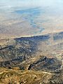 Aerial view of the Dez Reservoir

See also
[edit]References
[edit]- ^ "Dam and Reservoir Specification". Dez Dam Powerplant O&M Company (in Persian).
- ^ a b c d "New Page 1". www.khpimc.com. Archived from the original on July 13, 2011.
- ^ "Britannica Dez Dam". britannica.
- ^ a b "Hydroelectric Power Plants in Iran". IndustCards. Archived from the original on 8 September 2012. Retrieved 13 January 2015.
- ^ a b "The Dez Multipuropose Dam Project in Iran". San Jose State University. Retrieved 13 January 2015.
- ^ Ghazi, Iran (1977). The dez multi-purpose dam scheme, Khuzestan a socio-economic analysis (Doctoral). Durham University. Retrieved 13 January 2015.
- ^ Kiani, M. (May 2006). "Sedimentation Issues in the Dez Dam Reservoir" (PDF). The Role of Dams in the 21st Century. an Antonio River Authority: 409–411. Archived from the original (PDF) on 2015-10-05. Retrieved 2015-01-13.
External links
[edit]![]() Media related to Dez Dam at Wikimedia Commons
Media related to Dez Dam at Wikimedia Commons

| Major reservoirs and dams in Iran |
|  |
|---|---|---|
| Under construction | ||
| Ancient dams | ||
Also See: Dams and reservoirs in Iran | ||