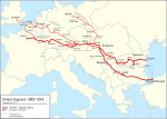
File:Orient-Express 1883-1914-3.png
Appearance

Size of this preview: 800 × 569 pixels. Other resolutions: 320 × 228 pixels | 640 × 455 pixels | 1,024 × 728 pixels | 1,280 × 910 pixels | 2,286 × 1,626 pixels.
Original file (2,286 × 1,626 pixels, file size: 758 KB, MIME type: image/png)
File history
Click on a date/time to view the file as it appeared at that time.
| Date/Time | Thumbnail | Dimensions | User | Comment | |
|---|---|---|---|---|---|
| current | 07:30, 3 January 2018 |  | 2,286 × 1,626 (758 KB) | Pechristener | korr Constanţa |
| 23:59, 8 March 2012 |  | 2,285 × 1,626 (751 KB) | Pechristener | alternative rout for trains to Nisch added | |
| 02:53, 22 February 2012 |  | 2,285 × 1,626 (665 KB) | Alphathon | Fixed Baltic Sea | |
| 02:50, 22 February 2012 |  | 2,285 × 1,626 (665 KB) | Alphathon | Fixed Baltic Sea | |
| 02:01, 22 February 2012 |  | 2,285 × 1,626 (751 KB) | Pechristener | border fix Romania in Dobruja area / color of train rout changed to red to avoid association with water / wrong file uploaded | |
| 02:00, 22 February 2012 |  | 2,285 × 1,626 (751 KB) | Pechristener | border fix Romania in Dobruja area / color of train rout changed to red to avoid association with water | |
| 23:13, 20 February 2012 |  | 2,285 × 1,626 (762 KB) | Pechristener | Borders of Romania fixed, Pitești ohne deutschen Namen, Timișoara -> Temesvár, Schriftgrößen von Mariatheresiopel/Subotica und Pitești grösser. | |
| 01:40, 19 February 2012 |  | 2,285 × 1,626 (761 KB) | Pechristener | unmotivated Zypern reomoved | |
| 18:31, 18 February 2012 |  | 2,285 × 1,626 (765 KB) | Pechristener | Finetuning gemäss Kartenwerkstatt | |
| 08:51, 17 February 2012 |  | 2,289 × 1,628 (719 KB) | Pechristener | grösseres Bild | |
| 08:25, 17 February 2012 |  | 1,337 × 951 (354 KB) | Pechristener | == {{int:filedesc}} == {{Information |Description={{en|Blank map of Europe showing national borders as they stood in 1914.}} *{{en}}Route of the Orient Express from 1883 to 1914 *{{de}}Karte des Orient Expresses von 1883 bis 1914 *{{fr}}Carte des trajets |
File usage
The following 2 pages use this file:
Global file usage
The following other wikis use this file:
- Usage on be-tarask.wikipedia.org
- Usage on be.wikipedia.org
- Usage on ca.wikipedia.org
- Usage on da.wikipedia.org
- Usage on de.wikipedia.org
- Usage on el.wikipedia.org
- Usage on eo.wikipedia.org
- Usage on es.wikipedia.org
- Usage on et.wikipedia.org
- Usage on fi.wikipedia.org
- Usage on fr.wikipedia.org
- Usage on hr.wikipedia.org
- Usage on hu.wikipedia.org
- Usage on id.wikipedia.org
- Usage on it.wikipedia.org
- Usage on ja.wikipedia.org
- Usage on lb.wikipedia.org
- Usage on nl.wikipedia.org
- Usage on nn.wikipedia.org
- Usage on no.wikipedia.org
- Usage on pl.wikipedia.org
- Usage on pms.wikipedia.org
- Usage on pt.wikipedia.org
- Usage on simple.wikipedia.org
- Usage on sv.wikipedia.org
- Usage on tr.wikipedia.org
- Usage on zh-yue.wikipedia.org


