

Halsteren: Difference between revisions
m Oops! |
FIxed typo |
||
| (11 intermediate revisions by 10 users not shown) | |||
| Line 1: | Line 1: | ||
{{Infobox settlement |
{{Infobox settlement |
||
| ⚫ | |||
|settlement_type = Dorp |
|||
| |
| other_name = Altere |
||
| |
| settlement_type = Town |
||
| native_name = <!-- if different from name --> |
|||
|coordinates_display = title,inline |
|||
| native_name_lang = nl |
|||
|coordinates_region = NL |
|||
| ⚫ | |||
| ⚫ | |||
| image_alt = |
|||
| ⚫ | |||
| ⚫ | |||
| ⚫ | |||
| image_flag = |
|||
| ⚫ | |||
| image_shield = |
|||
| ⚫ | |||
| nickname = |
|||
| ⚫ | |||
| |
| motto = |
||
| image_map = |
|||
|aantal woningen= 4.992 |
|||
| map_caption = |
|||
|latNS = N |
|||
| |
| image_map1 = |
||
| |
| map_caption1 = |
||
| |
| pushpin_map = Netherlands North Brabant#Netherlands |
||
| pushpin_label_position = |
|||
| ⚫ | |||
| |
| pushpin_mapsize = 250 |
||
| pushpin_map_caption = Location in the province of North Brabant in the Netherlands |
|||
| ⚫ | |||
| ⚫ | |||
| ⚫ | |||
| ⚫ | |||
| ⚫ | |||
| ⚫ | |||
| ⚫ | |||
| ⚫ | |||
| elevation_footnotes = <ref name="AHN">{{cite web |url = http://www.ahn.nl/postcodetool |title = Postcodetool for 4661AA |language = nl |work = Actueel Hoogtebestand Nederland |publisher = Het Waterschapshuis |access-date = 15 April 2022 }}</ref> |
|||
| elevation_m = 6 |
|||
| elevation_min_m = |
|||
| elevation_max_m = |
|||
| area_footnotes = <ref name="stat"/> |
|||
| area_total_km2 = 16.43 |
|||
| established_title = |
|||
| established_date = |
|||
| population_footnotes = <ref name="stat">{{cite web |url=https://www.cbs.nl/-/media/_excel/2021/48/kwb-2021.xls |title=Kerncijfers wijken en buurten 2021 |website=Central Bureau of Statistics |access-date=15 April 2022}}</ref> |
|||
| population_total = 12,325 |
|||
| population_as_of = 2021 |
|||
| population_demonym = |
|||
| population_note = |
|||
| population_density_km2 = auto |
|||
| timezone = [[Central European Time|CET]] |
|||
| utc_offset = +1 |
|||
| timezone_DST = [[Central European Summer Time|CEST]] |
|||
| utc_offset_DST = +2 |
|||
| postal_code_type = [[List of postal codes in the Netherlands|Postal code]] |
|||
| postal_code = 4661<ref name="stat"/> |
|||
| area_code_type = [[Telephone numbers in the Netherlands|Dialing code]] |
|||
| area_code = 0164 |
|||
| coordinates = {{coord|51|31|N|4|16|E|region:NL|display=inline, title}} |
|||
}} |
}} |
||
| ⚫ | '''Halsteren''' is a town in the [[Netherlands|Dutch]] province of [[North Brabant]]. It is located in the municipality of [[Bergen op Zoom]], about 1 km north of that city. Halsteren has an old church from the 14th century and a new church, built in 1919. A little village called Polder was located between Halsteren and Tholen in the Middle Ages. |
||
== History == |
|||
| ⚫ | '''Halsteren''' is a |
||
The village was first mentioned in 1272 as Halstert, and means "bend in the highland with a tail". It developed on a westward pointing sandy ridge.<ref>{{cite web|url=https://etymologiebank.nl/trefwoord/halsteren |title=Halsteren - (geografische naam) |website=Etymologiebank |access-date=15 April 2022 |language=nl}}</ref> |
|||
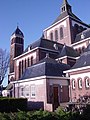
The Dutch Reformed church was built in the 14th century. It was extended in 1457. After a fire in 1607, it was extensively restored. In 1799, it was returned to the Catholic church and restored several times. In 1961, it became a Dutch Reformed church again. The Catholic St. Quirinus Church was built between 1911 and 1912 and has a double tower. The former town hall dates from 1633. It was restored and extended in 1917. It was restored in 1944 after a fire.<ref name="monument">{{cite book|url=https://dbnl.org/tekst/sten009monu02_01/sten009monu02_01_0073.php |title=Halsteren |author=Chris Kolman & Ronald Stenvert| year=1997 |publisher=Waanders |location=Zwolle |isbn=90 400 9945 6 |access-date=15 April 2022 |language=nl}}</ref> |
|||
| ⚫ | |||
| ⚫ | Halsteren was home to 538 people in 1840.<ref name="plaats">{{cite web|url=https://www.plaatsengids.nl/halsteren |title=Halsteren |website=Plaatsengids |access-date=15 April 2022 |language=nl}}</ref> Halsteren was a separate municipality until 1997, when it became a part of [[Bergen op Zoom]].<ref>{{Repertorium Nederlandse Gemeenten}}</ref> |
||
The village of Polder or Polre was located near Halsteren. It disappeared in a flood in 1570 and most of the village is still buried underneath a metre of mud.<ref name="plaats"/> |
|||
== Gallery == |
|||
<gallery> |
|||
File:Halsteren, de Sint Antoniusmolen RM19991 foto3 2015-05-24 11.43.jpg|Windmill: the Sint Antoniusmolen |
|||
File:Boerderij, achtergevel met zesdelige empire schuiframen en luiken - Lepelstraat - 20411835 - RCE.jpg|Farm in Halsteren |
|||
File:Quirinuschurch HalsterenDSC04639kl.jpg|Quirinus Church |
|||
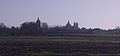
File:Blik op HalsterenDSC04646.jpg|View on Halsteren |
|||
</gallery> |
|||
==References== |
==References== |
||
{{Reflist}} |
|||
<references/> |
|||
==External links== |
==External links== |
||
*{{Commons category-inline}} |
*{{Commons category-inline}} |
||
*{{Kuyper|Halsteren|nb|halsteren}} Map of the former municipality, around 1868. |
|||
*[http://bhic.nl/index.php?id=44 Information about Halsteren on the site of the BHIC (Dutch)] |
*[http://bhic.nl/index.php?id=44 Information about Halsteren on the site of the BHIC (Dutch)] |
||
{{Authority control}} |
|||
{{North Brabant Province}} |
|||
[[Category:Municipalities of the Netherlands disestablished in 1997]] |
|||
[[Category:Populated places in North Brabant]] |
[[Category:Populated places in North Brabant]] |
||
[[Category:Former municipalities of North Brabant]] |
[[Category:Former municipalities of North Brabant]] |
||
[[Category:Bergen op Zoom]] |
|||
{{NorthBrabant-geo-stub}} |
|||
Latest revision as of 22:05, 13 April 2023
Halsteren
Altere | |
|---|---|
Town | |
 Former town hall of Halsteren | |
 Halsteren Location in the province of North Brabant in the Netherlands  Halsteren Halsteren (Netherlands) | |
| Coordinates: 51°31′N 4°16′E / 51.517°N 4.267°E | |
| Country | Netherlands |
| Province | North Brabant |
| Municipality | Bergen op Zoom |
| Area | |
| • Total | 16.43 km2 (6.34 sq mi) |
| Elevation | 6 m (20 ft) |
| Population (2021)[1] | |
| • Total | 12,325 |
| • Density | 750/km2 (1,900/sq mi) |
| Time zone | UTC+1 (CET) |
| • Summer (DST) | UTC+2 (CEST) |
| Postal code | 4661[1] |
| Dialing code | 0164 |
Halsteren is a town in the Dutch province of North Brabant. It is located in the municipality of Bergen op Zoom, about 1 km north of that city. Halsteren has an old church from the 14th century and a new church, built in 1919. A little village called Polder was located between Halsteren and Tholen in the Middle Ages.
History
[edit]The village was first mentioned in 1272 as Halstert, and means "bend in the highland with a tail". It developed on a westward pointing sandy ridge.[3]
The Dutch Reformed church was built in the 14th century. It was extended in 1457. After a fire in 1607, it was extensively restored. In 1799, it was returned to the Catholic church and restored several times. In 1961, it became a Dutch Reformed church again. The Catholic St. Quirinus Church was built between 1911 and 1912 and has a double tower. The former town hall dates from 1633. It was restored and extended in 1917. It was restored in 1944 after a fire.[4]
Halsteren was home to 538 people in 1840.[5] Halsteren was a separate municipality until 1997, when it became a part of Bergen op Zoom.[6]
The village of Polder or Polre was located near Halsteren. It disappeared in a flood in 1570 and most of the village is still buried underneath a metre of mud.[5]
Gallery
[edit]-
 Windmill: the Sint Antoniusmolen
 -
 Farm in Halsteren
 -
 Quirinus Church
 -
 View on Halsteren


References
[edit]- ^ a b c "Kerncijfers wijken en buurten 2021". Central Bureau of Statistics. Retrieved 15 April 2022.
- ^ "Postcodetool for 4661AA". Actueel Hoogtebestand Nederland (in Dutch). Het Waterschapshuis. Retrieved 15 April 2022.
- ^ "Halsteren - (geografische naam)". Etymologiebank (in Dutch). Retrieved 15 April 2022.
- ^ Chris Kolman & Ronald Stenvert (1997). Halsteren (in Dutch). Zwolle: Waanders. ISBN 90 400 9945 6. Retrieved 15 April 2022.
- ^ a b "Halsteren". Plaatsengids (in Dutch). Retrieved 15 April 2022.
- ^ Ad van der Meer and Onno Boonstra, Repertorium van Nederlandse gemeenten, KNAW, 2011.
External links
[edit] Media related to Halsteren at Wikimedia Commons
- Information about Halsteren on the site of the BHIC (Dutch)
| Authority control databases: Geographic |
|---|