

Likoma Island: Difference between revisions
Rif Winfield (talk | contribs) No edit summary |
|||
| (14 intermediate revisions by 10 users not shown) | |||
| Line 1: | Line 1: | ||
{{Short description|Island in Lake Malawi}} |
|||
{{Infobox islands |
{{Infobox islands |
||
| name = Likoma Island |
| name = Likoma Island |
||
| image_name = |
| image_name = File:Likoma sentinel2.jpg |
||
| image_caption = |
| image_caption = [[Sentinel-2]] satellite image of the island. |
||
| image_size = |
| image_size = |
||
| map = Malawi |
| map = Malawi |
||
| map_caption = |
| map_caption = |
||
| Line 28: | Line 29: | ||
| ethnic_groups = |
| ethnic_groups = |
||
| additional_info = |
| additional_info = |
||
| map_image={{maplink|frame=yes|plain=yes|type=shape}} |
|||
}} |
|||
|waterbody=Lake Malawi}} |
|||
'''Likoma Island''' is the larger of two |
'''Likoma Island''' is the larger of two islands in [[Lake Malawi]], in [[East Africa]], the smaller being the nearby [[Chizumulu]]. Likoma and Chizumulu both belong to Malawi, and together they make up the [[Likoma District]]. Although both islands lie just a few kilometres from [[Mozambique]], and are entirely surrounded by Mozambican [[territorial waters]], they are both [[exclave]]s of [[Malawi]]. |
||
==Geography== |
==Geography== |
||
| ⚫ | |||
[[File:Likoma (satellite).jpg|thumb|Satellite image of Chizumulu and Likoma islands]] |
|||
| ⚫ | |||
==History== |
==History== |
||
In 1880 missionaries from the [[Universities' Mission to Central Africa]], founded in response to a plea by [[David Livingstone]], established their headquarters on Likoma Island. |
In 1880 missionaries from the [[Universities' Mission to Central Africa]], founded in response to a plea by [[David Livingstone]], established their headquarters on Likoma Island. Due to the presence of British missionaries, the island was assigned to Malawi rather than Mozambique when national borders in East Africa were established after [[World War II]]. |
||
==Natural environment== |
==Natural environment== |
||
Despite a high population density, the natural environment of Likoma island is largely unspoiled. The coast is varied, with rocky slopes, sandy bays and swamps. |
Despite a high population density, the natural environment of Likoma island is largely unspoiled. The coast is varied, with rocky slopes, sandy bays and swamps. The interior of the island is mostly covered by [[grassland]], with a large number of baobab trees (of the ''[[Adansonia digitata]]'' species) and [[Mangifera indica|mango trees]]. Fauna is mostly composed of small [[reptile|reptilians]], [[amphibian]]s, [[bird]]s and a number of [[invertebrate]]s, including [[Platyoides|scorpion spider]]s. On the coast, [[crocodile]]s are occasionally seen. The waters around Likoma, as is usual in Lake Malawi, host a number of [[cichlids]]; some species, such as ''[[Labidochromis caeruleus|Labidochromis caeruleus likomae]]'', are [[endemism|endemic]] of the Likoma area. |
||
==Population== |
==Population== |
||
Likoma is densely populated, with about 10,500 inhabitants dispersed in a dozen settlements, the main being the eponymous town of [[Likoma, Malawi|Likoma]]; the nearby island of Chizumulu has a further 4,000 inhabitants. The most represented ethnic groups are the [[Chewa people|Nyanja]] people (60%) and the [[Tonga people of Malawi|Tonga people]] (25%), followed by smaller groups of [[Tumbuka people|Tumbuka]], [[Yao people (East Africa)|Yao]], and [[Chewa people|Chewa]]. Their main economic activity is [[fishing]], although agriculture (mainly [[Oryza sativa|rice]] and [[cassava]]) is also represented. The town of Mbamba hosts a busy market. It is also the site of the [[Anglicanism|Anglican]] cathedral of St Peter, one of the largest churches in Africa.{{ |
Likoma is densely populated, with about 10,500 inhabitants dispersed in a dozen settlements, the main being the eponymous town of [[Likoma, Malawi|Likoma]]; the nearby island of Chizumulu has a further 4,000 inhabitants. The most represented ethnic groups are the [[Chewa people|Nyanja]] people (60%) and the [[Tonga people of Malawi|Tonga people]] (25%), followed by smaller groups of [[Tumbuka people|Tumbuka]], [[Yao people (East Africa)|Yao]], and [[Chewa people|Chewa]]. Their main economic activity is [[fishing]], although agriculture (mainly [[Oryza sativa|rice]] and [[cassava]]) is also represented. The town of Mbamba hosts a busy market. It is also the site of the [[Anglicanism|Anglican]] cathedral of St Peter, one of the largest churches in Africa.<ref>{{Cite web|title=Malawi Tours and Safaris {{!}} View Rates and Prices (2020) : MoAfrika Tours|url=https://www.moafrikatours.com/malawi-safaris|website=MoAfrika|language=en|access-date=2020-05-27}}</ref> |
||
As a consequence of [[poverty]] and insufficient hospitals, the situation of [[public health]] on the island is critical, although [[malaria]] (which is widespread in Malawi) has not been reported. |
As a consequence of [[poverty]] and insufficient hospitals, the situation of [[public health]] on the island is critical, although [[malaria]] (which is widespread in Malawi) has not been reported. Recently{{when|date=January 2023}}, Likoma has been the subject of a scientific study on the [[epidemiology]] of [[HIV]] and other sexually transmitted diseases.<ref>Stephane Helleringer ''et al.'', [http://www.ssc.upenn.edu/~hpkohler/working-papers/hell06likdoc.pdf The Likoma Network Study]{{dead link|date=December 2017 |bot=InternetArchiveBot |fix-attempted=yes }}</ref> Despite the minimal economic development of Likoma, there are several schools serving all settlements, and [[literacy]] is thus widespread. |
||
==Infrastructures and transportation== |
==Infrastructures and transportation== |
||
Likoma has no paved roads, and there are very few [[motor vehicle]]s. |
Likoma has no paved roads, and there are very few [[motor vehicle]]s. [[Electricity]] is provided by a generator and a solar bank. This affords the island 24 hour electricity, with the exception of 1-5 minutes at around 10 pm, while they switch the power source. There is a small [[telephone network]] on the island, although telephones themselves are quite rare.<ref>{{Cite web|title=The islands of the lake|url=http://sianandsteve.weebly.com/the-islands-of-the-lake.html|website=Kaya Papaya|access-date=2020-05-27}}</ref> Likoma has a tarred airstrip and can be reached by plane from [[Lilongwe]].<ref>{{Cite web|title=The islands of the lake|url=http://sianandsteve.weebly.com/the-islands-of-the-lake.html|website=Kaya Papaya|access-date=2020-05-27}}</ref> |
||
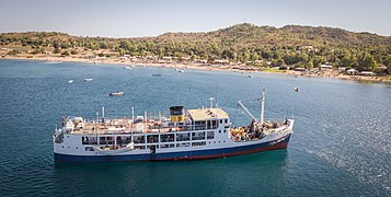
The island's main mode of transportation is provided by the [[MV Ilala]] [[Steamboat|steamer]] boat that circumnavigates Lake Malawi, stopping over at all the main settlements on the coast and the islands. In addition, The MV Chambo links the island with the town of Nkhata Bay on the west side of the lake once a week. Smaller boats (including [[dhow]]s) cross the [[strait]] between Likoma and Chizumulu, and also between Likoma and [[Cobue]] in Mozambique. Both goods and people are transported through these routes. |
The island's main mode of transportation is provided by the [[MV Ilala]] [[Steamboat|steamer]] boat that circumnavigates Lake Malawi, stopping over at all the main settlements on the coast and the islands. In addition, The MV Chambo links the island with the town of Nkhata Bay on the west side of the lake once a week. Smaller boats (including [[dhow]]s) cross the [[strait]] between Likoma and Chizumulu, and also between Likoma and [[Cobue]] in Mozambique. Both goods and people are transported through these routes. |
||
As Likoma is a relevant tourist destination in Malawi, there are a few hotels and backpacker hostels, usually based on [[ecotourism|ecotouristic]] principles. |
As Likoma is a relevant tourist destination in Malawi, there are a few hotels and backpacker hostels, usually based on [[ecotourism|ecotouristic]] principles. The waters around Likoma are appreciated for [[snorkelling]] and [[Underwater diving|diving]]. |
||
== Gallery == |
|||
<gallery mode="packed"> |
|||
File:Baobab trees likoma island.jpg|Baobab trees |
|||
File:Ilala in Likoma Island.jpg|[[MV Ilala]] |
|||
File:Chiponde.jpg|alt= |
|||
</gallery> |
|||
==References== |
==References== |
||
Latest revision as of 23:03, 30 December 2023
 Sentinel-2 satellite image of the island. | |
 | |
 Likoma Island | |
| Geography | |
|---|---|
| Location | Lake Malawi |
| Archipelago | Likoma Islands |
| Adjacent to | Lake Malawi |
| Total islands | 2 |
| Major islands | Likoma, Chizumulu Island |
| Area | 18 km2 (6.9 sq mi) |
| Administration | |
Malawi | |
| Region | Northern Region |
| District | Likoma |
| Capital and largest city | Likoma |
| Demographics | |
| Population | 9,000 |
| Pop. density | 500/km2 (1300/sq mi) |
Likoma Island is the larger of two islands in Lake Malawi, in East Africa, the smaller being the nearby Chizumulu. Likoma and Chizumulu both belong to Malawi, and together they make up the Likoma District. Although both islands lie just a few kilometres from Mozambique, and are entirely surrounded by Mozambican territorial waters, they are both exclaves of Malawi.
Geography
[edit]The island has an overall area of 18 km2, and is located in the north-eastern part of Lake Malawi, 7 km north-west of Cobue, Mozambique. The closest town on the Malawian coast is Chintheche.
History
[edit]In 1880 missionaries from the Universities' Mission to Central Africa, founded in response to a plea by David Livingstone, established their headquarters on Likoma Island. Due to the presence of British missionaries, the island was assigned to Malawi rather than Mozambique when national borders in East Africa were established after World War II.
Natural environment
[edit]Despite a high population density, the natural environment of Likoma island is largely unspoiled. The coast is varied, with rocky slopes, sandy bays and swamps. The interior of the island is mostly covered by grassland, with a large number of baobab trees (of the Adansonia digitata species) and mango trees. Fauna is mostly composed of small reptilians, amphibians, birds and a number of invertebrates, including scorpion spiders. On the coast, crocodiles are occasionally seen. The waters around Likoma, as is usual in Lake Malawi, host a number of cichlids; some species, such as Labidochromis caeruleus likomae, are endemic of the Likoma area.
Population
[edit]Likoma is densely populated, with about 10,500 inhabitants dispersed in a dozen settlements, the main being the eponymous town of Likoma; the nearby island of Chizumulu has a further 4,000 inhabitants. The most represented ethnic groups are the Nyanja people (60%) and the Tonga people (25%), followed by smaller groups of Tumbuka, Yao, and Chewa. Their main economic activity is fishing, although agriculture (mainly rice and cassava) is also represented. The town of Mbamba hosts a busy market. It is also the site of the Anglican cathedral of St Peter, one of the largest churches in Africa.[1]
As a consequence of poverty and insufficient hospitals, the situation of public health on the island is critical, although malaria (which is widespread in Malawi) has not been reported. Recently[when?], Likoma has been the subject of a scientific study on the epidemiology of HIV and other sexually transmitted diseases.[2] Despite the minimal economic development of Likoma, there are several schools serving all settlements, and literacy is thus widespread.
Infrastructures and transportation
[edit]Likoma has no paved roads, and there are very few motor vehicles. Electricity is provided by a generator and a solar bank. This affords the island 24 hour electricity, with the exception of 1-5 minutes at around 10 pm, while they switch the power source. There is a small telephone network on the island, although telephones themselves are quite rare.[3] Likoma has a tarred airstrip and can be reached by plane from Lilongwe.[4]
The island's main mode of transportation is provided by the MV Ilala steamer boat that circumnavigates Lake Malawi, stopping over at all the main settlements on the coast and the islands. In addition, The MV Chambo links the island with the town of Nkhata Bay on the west side of the lake once a week. Smaller boats (including dhows) cross the strait between Likoma and Chizumulu, and also between Likoma and Cobue in Mozambique. Both goods and people are transported through these routes.
As Likoma is a relevant tourist destination in Malawi, there are a few hotels and backpacker hostels, usually based on ecotouristic principles. The waters around Likoma are appreciated for snorkelling and diving.
Gallery
[edit]-
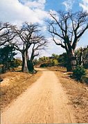 Baobab trees
 -
-


References
[edit]- ^ "Malawi Tours and Safaris | View Rates and Prices (2020) : MoAfrika Tours". MoAfrika. Retrieved 2020-05-27.
- ^ Stephane Helleringer et al., The Likoma Network Study[permanent dead link]
- ^ "The islands of the lake". Kaya Papaya. Retrieved 2020-05-27.
- ^ "The islands of the lake". Kaya Papaya. Retrieved 2020-05-27.