Makena, Hawaii: Difference between revisions
Appearance
Content deleted Content added
m clean up, replaced: Political divisions of the United States|State → U.S. state|State, List of countries| → List of sovereign states|, United States → United States (2) using AWB |
m Preparing Template:Round for merging by adding precision parameter per discussion at TFD (Task 2: BRFA *in trial*) |
||
| Line 166: | Line 166: | ||
|Oct mean F = {{round|{{#expr:(86.6 +68 )/2}}|1}} |
|Oct mean F = {{round|{{#expr:(86.6 +68 )/2}}|1}} |
||
|Nov mean F = {{round|{{#expr:(84.1 +66.7 )/2}}|1}} |
|Nov mean F = {{round|{{#expr:(84.1 +66.7 )/2}}|1}} |
||
|Dec mean F = {{ |
|Dec mean F = {{Rnd|{{#expr:(81.8 |
||
+64.2 |
+64.2 |
||
)/2}}|1}} |
)/2|3}}|1}} |
||
|Jan rain inch = 2.6 |
|Jan rain inch = 2.6 |
||
|Feb rain inch = 1.24 |
|Feb rain inch = 1.24 |
||
Revision as of 18:40, 16 March 2019
Makena, Hawaii | |
|---|---|
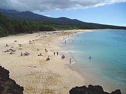
 Makena State Park, "Big Beach" side. | |
 | |
| Coordinates: 20°39′14″N 156°26′25″W / 20.65389°N 156.44028°W | |
| Country | United States |
| State | Hawaii |
| County | Maui |
| Area | |
| • Total | 11.5 sq mi (29.9 km2) |
| • Land | 9.5 sq mi (24.5 km2) |
| • Water | 2.1 sq mi (5.4 km2) |
| Population (2010) | |
| • Total | 99 |
| • Density | 8.6/sq mi (3.3/km2) |
| Time zone | UTC-10 (Hawaii-Aleutian) |
| Area code | 808 |
Makena is a census-designated place (CDP) in Maui County, Hawaiʻi, United States. As of the 2010 census, it had a population of 99.[1] Prior to 2010, the area was part of the Wailea-Makena census-designated place.
Geography
Makena is located at 20°39′14″N 156°26′25″W / 20.65389°N 156.44028°W (20.6539, -156.4403).[2]
According to the United States Census Bureau, the CDP has a total area of 11.5 square miles (29.9 km2), of which 9.5 square miles (24.5 km2) is land and 2.1 square miles (5.4 km2), or 17.93%, is water.[3]
| Climate data for Makena | |||||||||||||
|---|---|---|---|---|---|---|---|---|---|---|---|---|---|
| Month | Jan | Feb | Mar | Apr | May | Jun | Jul | Aug | Sep | Oct | Nov | Dec | Year |
| Record high °F (°C) | 90 (32) |
87 (31) |
89 (32) |
89 (32) |
90 (32) |
91 (33) |
93 (34) |
94 (34) |
94 (34) |
92 (33) |
90 (32) |
89 (32) |
94 (34) |
| Mean daily maximum °F (°C) | 80.4 (26.9) |
80.5 (26.9) |
81.8 (27.7) |
83.2 (28.4) |
84.1 (28.9) |
86.3 (30.2) |
87.3 (30.7) |
87.8 (31.0) |
87.3 (30.7) |
86.6 (30.3) |
84.1 (28.9) |
81.8 (27.7) |
84.3 (29.0) |
| Daily mean °F (°C) | 71.8 (22.1) |
71.6 (22.0) |
72.6 (22.6) |
73.7 (23.2) |
74.9 (23.8) |
76.8 (24.9) |
77.9 (25.5) |
78.3 (25.7) |
78.0 (25.6) |
77.3 (25.2) |
75.4 (24.1) |
73.0 (22.8) |
75.1 (24.0) |
| Mean daily minimum °F (°C) | 63.2 (17.3) |
62.7 (17.1) |
63.4 (17.4) |
64.1 (17.8) |
65.6 (18.7) |
67.3 (19.6) |
68.4 (20.2) |
68.8 (20.4) |
68.7 (20.4) |
68 (20) |
66.7 (19.3) |
64.2 (17.9) |
65.9 (18.8) |
| Record low °F (°C) | 54 (12) |
54 (12) |
54 (12) |
58 (14) |
54 (12) |
62 (17) |
62 (17) |
62 (17) |
61 (16) |
61 (16) |
56 (13) |
57 (14) |
54 (12) |
| Average rainfall inches (mm) | 2.6 (66) |
1.24 (31) |
1.5 (38) |
0.85 (22) |
0.83 (21) |
0.41 (10) |
0.62 (16) |
0.55 (14) |
0.9 (23) |
1.7 (43) |
1.73 (44) |
2.74 (70) |
15.67 (398) |
| Average precipitation days | 6 | 5 | 4 | 4 | 4 | 2 | 3 | 2 | 4 | 4 | 5 | 5 | 48 |
| Source: WRCC | |||||||||||||
See also
- List of beaches in Hawaii#Maui
- Makena Beach & Golf Resort - A hotel/ resort in the Makena area.
References
- ^ "Profile of General Population and Housing Characteristics: 2010 Demographic Profile Data (DP-1): Makena CDP, Hawaii". U.S. Census Bureau, American Factfinder. Retrieved December 29, 2011.
- ^ "US Gazetteer files: 2010, 2000, and 1990". United States Census Bureau. 2011-02-12. Retrieved 2011-04-23.
- ^ "Geographic Identifiers: 2010 Demographic Profile Data (G001): Makena CDP, Hawaii". U.S. Census Bureau, American Factfinder. Retrieved December 29, 2011.
External links
 Media related to Makena, Hawaii at Wikimedia Commons
- Daily newspaper
