Osiedle Dziesięciny II, Białystok: Difference between revisions
Appearance
Content deleted Content added
Adding geodata: {{coord missing|Poland}} |
→top: Replaced {{unreferenced}} with {{more citations needed}} and other General fixes |
||
| (14 intermediate revisions by 11 users not shown) | |||
| Line 1: | Line 1: | ||
{{More citations needed|date=January 2024}} |
|||
{| class="toccolours" border="1" cellpadding="4" style="float: right; margin: 0 0 1em 1em; width:250px; border-collapse: collapse; font-size: 95%; clear: right" |
|||
|+ style="margin-left: inherit; font-size: medium;" | '''Osiedle Dziesięciny II''' |
|||
{{Infobox settlement |
|||
|- align=center |
|||
<!-- See Template:Infobox settlement for additional fields and descriptions --> |
|||
| colspan="2" style="background:#ffffff;" | [[Image:Dziesieciny II.png|180px|Location of Osiedle Dziesięciny II]] |
|||
| name = [[File:POL Białystok COA.svg|20px]] Dziesięciny II |
|||
|- style="vertical-align: top;" |
|||
| native_name = |
|||
| '''Area''' |
|||
| native_name_lang = |
|||
| - |
|||
| settlement_type = District (''[[osiedle]]'') of [[Białystok]] |
|||
|- style="vertical-align: top;" |
|||
| image_skyline = 20200712 145649 Białystok.jpg |
|||
| '''Population''' |
|||
| image_alt = |
|||
| - |
|||
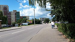
| image_caption = Gajowa Street in the district, July 2020 |
|||
|- style="vertical-align: top;" |
|||
| image_flag = |
|||
| '''Population density''' |
|||
| flag_alt = |
|||
| - |
|||
| image_seal = |
|||
|- style="vertical-align: top;" |
|||
| seal_alt = |
|||
| colspan=2 |<center><font size="-1">'''Website'''</font></center> |
|||
| image_shield = |
|||
| ⚫ | |||
| shield_alt = |
|||
| nickname = |
|||
| motto = |
|||
| mottoeng = |
|||
| image_map = Podział administracyjny Białegostoku 2021 osiedle Dziesięciny II.svg |
|||
| map_alt = |
|||
| map_caption = Location of Dziesięciny II District within [[Białystok]] |
|||
| pushpin_map = |
|||
| pushpin_label_position = |
|||
| pushpin_map_alt = |
|||
| pushpin_map_caption = |
|||
| coordinates = {{coord|53.155276|23.118389|format=dms|display=inline,title|type:landmark}} |
|||
| coor_pinpoint = |
|||
| coordinates_footnotes = |
|||
| subdivision_type = Country |
|||
| subdivision_name = {{flag|Poland}} |
|||
| subdivision_type1 = [[Voivodeships of Poland|Voivodeship]] |
|||
| subdivision_name1 = [[Podlaskie Voivodeship|Podlaskie]] |
|||
| subdivision_type2 = City |
|||
| subdivision_name2 = [[Białystok]] |
|||
| established_title = |
|||
| established_date = |
|||
| founder = |
|||
| seat_type = |
|||
| seat = |
|||
| government_footnotes = |
|||
| leader_party = |
|||
| leader_title = |
|||
| leader_name = |
|||
| unit_pref = Metric<!-- or US or UK --> |
|||
| area_footnotes = <ref>{{cite web |title = Program rewitalizacji miasta Białegostoku na lata 2017-2023 |url = https://docplayer.pl/52160552-Uchwala-nr-xxxiv-559-17-rady-miasta-bialystok-z-dnia-24-kwietnia-2017-r-w-sprawie-programu-rewitalizacji-miasta-bialegostoku-na-lata.html |language=pl}}</ref> |
|||
| area_total_km2 = 1.619 |
|||
| area_land_km2 = |
|||
| area_water_km2 = |
|||
| area_water_percent = |
|||
| area_note = |
|||
| elevation_footnotes = |
|||
| elevation_m = |
|||
| population_footnotes = |
|||
| population_total = |
|||
| population_as_of = |
|||
| population_density_km2 = auto |
|||
| population_demonym = |
|||
| population_note = |
|||
| timezone1 = |
|||
| utc_offset1 = |
|||
| timezone1_DST = |
|||
| utc_offset1_DST = |
|||
| postal_code_type = |
|||
| postal_code = |
|||
| area_code_type = |
|||
| area_code = |
|||
| iso_code = |
|||
| website = <!-- {{URL|example.com}} --> |
|||
| footnotes = |
|||
| ⚫ | |||
'''Dziesięciny II''' is one of the districts of the [[Poland|Polish]] city of [[Białystok]]. |
'''Dziesięciny II''' is one of the districts of the [[Poland|Polish]] city of [[Białystok]]. |
||
==References== |
|||
| ⚫ | |||
{{Reflist}} |
|||
== External links == |
|||
| ⚫ | |||
{{commons category|Dziesięciny II (district of Białystok)}} |
|||
| ⚫ | |||
{{coord missing|Poland}} |
|||
{{DEFAULTSORT:Dziesieciny Ii}} |
|||
[[Category:Districts of Białystok]] |
[[Category:Districts of Białystok]] |
||
[[pl:Dziesięciny II]] |
|||
| ⚫ | |||
Latest revision as of 05:27, 25 January 2024
This article needs additional citations for verification. (January 2024) |
 Gajowa Street in the district, July 2020 | |
 Location of Dziesięciny II District within Białystok | |
| Coordinates: 53°09′19″N 23°07′06″E / 53.155276°N 23.118389°E | |
| Country | |
| Voivodeship | Podlaskie |
| City | Białystok |
| Area | |
• Total | 1.619 km2 (0.625 sq mi) |
Dziesięciny II is one of the districts of the Polish city of Białystok.
References
[edit]External links
[edit]Wikimedia Commons has media related to Dziesięciny II (district of Białystok).