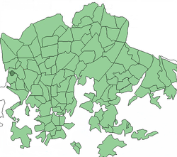
Pajamäki
Appearance
You can help expand this article with text translated from the corresponding article in Finnish. (December 2009) Click [show] for important translation instructions.
|
Pajamäki
Smedjebacka | |
|---|---|
 Position of Pajamäki within Helsinki | |
| Country | |
| Region | Uusimaa |
| Sub-region | Greater Helsinki |
| Municipality | Helsinki |
| District | Western |
Area | 0.27 km2 (0.10 sq mi) |
| Population | 1,802 |
| • Density | 6,750/km2 (17,500/sq mi) |
| Postal codes | 00360 |
| Subdivision number | 462 |
| Neighbouring subdivisions | Pitäjänmäen teollisuusalue, Tali, Espoo |
Pajamäki (Swedish: Smedjebacka) is a neighborhood of Helsinki, Finland. It is located in Pitäjänmäki district.
As of 2008[update], Pajamäki has 1,802 inhabitants living in an area of 0.27 km2.[1]
References
- ^ http://www.hel2.fi/tietokeskus/julkaisut/pdf/08_10_24_Tilasto_Vuori_hki_alueittain.pdf Information about districts of Helsinki. Pitäjänmäki on pages 72–75.
60°13′10″N 24°51′20″E / 60.21944°N 24.85556°E
