Salima District: Difference between revisions
mNo edit summary |
Nonononoono (talk | contribs) No edit summary |
||
| (47 intermediate revisions by 40 users not shown) | |||
| Line 1: | Line 1: | ||
{{short description|District of Malawi}} |
|||
'''Salima''' is a [[Districts of Malawi|district]] in the [[Central Region, Malawi|Central Region]] of [[Malawi]]. The capital is [[Salima]]. The district covers an area of 2,196 km.² and has a population of 248,214. |
|||
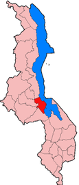
[[Image:MW-Salima.png|right|115px|Location of Salima District in Malawi]] |
|||
'''Salima''' is a [[Districts of Malawi|district]] in the [[Central Region, Malawi|Central Region]] of [[Malawi]]. The city of [[Salima, Malawi|Salima]] is the district's capital. The district covers an area of 2,196 km.² and has a population of 478,346.<ref name="Census2018">{{cite web|url=http://www.nsomalawi.mw/images/stories/data_on_line/demography/census_2018/2018%20Malawi%20Population%20and%20Housing%20Census%20Main%20Report.pdf|title=2018 Population and Housing Census Main Report |publisher=Malawi National Statistical Office |accessdate=25 December 2019}}</ref> The beach at Senga Bay is the weekend retreat of many from the capital, Lilongwe, and has hosted the annual Lake of Stars festival since 2008, when it was moved from [[Chintheche]] in order to be less remote. There is a range of accommodation options in the area, though most are a few kilometers off the main road. |
|||
==Demographics== |
|||
At the [[2018 Census of Malawi]], the distribution of the population of Salima district by [[ethnic group]] was as follows:<ref>[http://www.nsomalawi.mw/images/stories/data_on_line/demography/census_2018/2018%20Malawi%20Population%20and%20Housing%20Census%20Main%20Report.pdf 2018 Malawi Population and Housing Census Main Report]</ref> |
|||
* 72.9% [[Chewa people|Chewa]] |
|||
* 19.0% [[Yao people (East Africa)|Yao]] |
|||
* 2.9% [[Ngoni people|Ngoni]] |
|||
* 2.0% [[Lomwe people|Lomwe]] |
|||
* 1.0% [[Tumbuka people|Tumbuka]] |
|||
* 0.7% [[Nyanja people|Nyanja]] |
|||
* 0.5% [[Tonga people (Malawi)|Tonga]] |
|||
* 0.4% [[Sena people|Sena]] |
|||
* 0.3% [[Mang'anja]] |
|||
* 0.1% [[Nyakyusa people|Nkhonde]] |
|||
* 0.0% [[Lambya people|Lambya]] |
|||
* 0.0% [[Sukwa people|Sukwa]] |
|||
* 0.1% Others |
|||
==Government and administrative divisions== |
|||
There are five [[National Assembly of Malawi|National Assembly]] constituencies in Salima: |
|||
* Salima - Central |
|||
* Salima - North |
|||
* Salima - South |
|||
* Salima - South East |
|||
* Salima - North West |
|||
Since the [[Malawian general election, 2009|2009 election]] most of these constituencies (except Salima South, which has been held by members of the [[Democratic Progressive Party]]), have been held by members of the [[Malawi Congress Party]].<ref>[http://www.parliament.gov.mw/mps.php?mode=wd&dis=Salima Parliament of Malawi - Members of Parliament - Salima District]</ref> |
|||
[[Image:Senga Bay sunrise.JPG|200px|right|thumb|Senga Bay beach]] |
|||
==Villages== |
|||
<!---♦♦♦ Only add a location to this list if they already have their own article on the English Wikipedia ♦♦♦---> |
|||
<!---♦♦♦ Please keep the list in alphabetical order ♦♦♦---> |
|||
*[[Mbaluko]] |
|||
==References== |
|||
{{reflist}} |
|||
{{Regions and districts of Malawi}} |
|||
{{Coord|13|45|S|34|30|E|region:MW_type:adm1st|display=title}} |
|||
{{Authority control}} |
|||
| ⚫ | |||
[[Category:Districts of Malawi]] |
[[Category:Districts of Malawi]] |
||
[[Category:Districts in Central Region, Malawi]] |
|||
| ⚫ | |||
Latest revision as of 18:29, 24 March 2024

Salima is a district in the Central Region of Malawi. The city of Salima is the district's capital. The district covers an area of 2,196 km.² and has a population of 478,346.[1] The beach at Senga Bay is the weekend retreat of many from the capital, Lilongwe, and has hosted the annual Lake of Stars festival since 2008, when it was moved from Chintheche in order to be less remote. There is a range of accommodation options in the area, though most are a few kilometers off the main road.
Demographics
[edit]At the 2018 Census of Malawi, the distribution of the population of Salima district by ethnic group was as follows:[2]
- 72.9% Chewa
- 19.0% Yao
- 2.9% Ngoni
- 2.0% Lomwe
- 1.0% Tumbuka
- 0.7% Nyanja
- 0.5% Tonga
- 0.4% Sena
- 0.3% Mang'anja
- 0.1% Nkhonde
- 0.0% Lambya
- 0.0% Sukwa
- 0.1% Others
Government and administrative divisions
[edit]There are five National Assembly constituencies in Salima:
- Salima - Central
- Salima - North
- Salima - South
- Salima - South East
- Salima - North West
Since the 2009 election most of these constituencies (except Salima South, which has been held by members of the Democratic Progressive Party), have been held by members of the Malawi Congress Party.[3]
Villages
[edit]References
[edit]- ^ "2018 Population and Housing Census Main Report" (PDF). Malawi National Statistical Office. Retrieved 25 December 2019.
- ^ 2018 Malawi Population and Housing Census Main Report
- ^ Parliament of Malawi - Members of Parliament - Salima District
13°45′S 34°30′E / 13.750°S 34.500°E