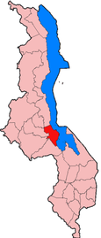
Salima District: Difference between revisions
Appearance
Content deleted Content added
m r2.7.1) (Robot: Adding ru:Салима (округ) |
m Bot: Migrating 19 interwiki links, now provided by Wikidata on d:q195353 (Report Errors) |
||
| Line 11: | Line 11: | ||
[[Category:Districts of Malawi]] |
[[Category:Districts of Malawi]] |
||
[[Category:Central Region, Malawi]] |
[[Category:Central Region, Malawi]] |
||
{{Malawi-geo-stub}} |
{{Malawi-geo-stub}} |
||
[[bg:Салима]] |
|||
[[br:Salima (distrig)]] |
|||
[[es:Distrito de Salima]] |
|||
[[fr:District de Salima]] |
|||
[[gl:Distrito de Salima]] |
|||
[[ko:살리마 현]] |
|||
[[id:Distrik Salima]] |
|||
[[it:Distretto di Salima]] |
|||
[[ka:სალიმის რაიონი]] |
|||
[[ms:Daerah Salima]] |
|||
[[nl:Salima (district)]] |
|||
[[ja:サリマ]] |
|||
[[no:Salima (distrikt)]] |
|||
[[pl:Dystrykt Salima]] |
|||
[[pt:Salima]] |
|||
[[ro:Districtul Salima]] |
|||
[[ru:Салима (округ)]] |
|||
[[sv:Salima]] |
|||
[[zh:薩利馬縣]] |
|||
Revision as of 00:07, 23 February 2013

Salima is a district in the Central Region of Malawi. The capital is Salima. The district covers an area of 2,196 km.² and has a population of 248,214. The beach at Senga Bay is the weekend retreat of many from the capital, Lilongwe, and has hosted the annual Lake of Stars festival since 2008, when it was moved from Chintheche in order to be less remote. There is a range of accommodation options in the area, though most are a few km off the main road.