Tel Mond: Difference between revisions
| Line 35: | Line 35: | ||
Before the 20th century, the area of Tel Mond formed part of the Forest of Sharon, a hallmark of the region's historical landscape. It was an open [[woodland]] dominated by Mount Tabor Oak ([[Quercus ithaburensis]]), which extended from [[Kfar Yona]] in the north to [[Ra'anana|Ra’ananna]] in the south. The local inhabitants traditionally used the area for [[pasture]], [[firewood]] and intermittent [[Agriculture|cultivation]]. The intensification of settlement and agriculture in the [[Israeli coastal plain|coastal plain]] during the 19th century under the [[Ottoman Empire]] rule led to [[deforestation]] and subsequent [[environmental degradation]].<ref>{{Cite journal |last=Marom |first=Roy |date=2022-12-01 |title=יער השרון (אל-ע'אבה) בתקופה העות'מאנית: בתקופה מהמחקר חדשות תובנות הגיאוגרפי-היסטורי The Oak Forest of the Sharon (al-Ghaba) in the Ottoman Period: New Insights from Historical- Geographical Studies |url=https://www.academia.edu/93207554 |journal=Muse |volume=5 |pages=90–107}}</ref> |
Before the 20th century, the area of Tel Mond formed part of the Forest of Sharon, a hallmark of the region's historical landscape. It was an open [[woodland]] dominated by Mount Tabor Oak ([[Quercus ithaburensis]]), which extended from [[Kfar Yona]] in the north to [[Ra'anana|Ra’ananna]] in the south. The local inhabitants traditionally used the area for [[pasture]], [[firewood]] and intermittent [[Agriculture|cultivation]]. The intensification of settlement and agriculture in the [[Israeli coastal plain|coastal plain]] during the 19th century under the [[Ottoman Empire]] rule led to [[deforestation]] and subsequent [[environmental degradation]].<ref>{{Cite journal |last=Marom |first=Roy |date=2022-12-01 |title=יער השרון (אל-ע'אבה) בתקופה העות'מאנית: בתקופה מהמחקר חדשות תובנות הגיאוגרפי-היסטורי The Oak Forest of the Sharon (al-Ghaba) in the Ottoman Period: New Insights from Historical- Geographical Studies |url=https://www.academia.edu/93207554 |journal=Muse |volume=5 |pages=90–107}}</ref> |
||
Tel Mond was founded on 16 June 1929 by [[Alfred Mond, 1st Baron Melchett]]. Lord Melchett was a British industrialist, a former cabinet minister and president of the British Zionist Foundation. The Palestine Plantations Company, headed by Mond, purchased land in the region and planted citrus orchards to provide employment for Jewish laborers.<ref name="crwflags">{{cite web |url=http://www.crwflags.com/fotw/flags/il-lctmn.html |title=Tel Mond (Israel) |publisher = CRW Flags |accessdate=24 January 2014}}</ref><ref>{{cite book | chapter = Tel Mond | title = Encyclopaedia Judaica | publisher = Thomson Gale | year = 2007 | edition = 2 | volume = 19 | page = 597}}</ref> In 1933, a group of farmers purchased land from the company and established [[moshav]] Tel Mond. In 1936, another group established moshav '''Kfar Ziv''', named after [[Baron Sieff]] who followed Lord Melchett and settled in Tel Mond with his wife. In 1943, new immigrants from [[Yemen]] established Shechunat Ya'akov. The surrounding moshavim, [[Kfar Hess]], [[Herut, Israel|Herut]] and [[Ein Vered]], were also founded by the pioneers of Tel Mond.<ref name="Haaretz Day in the Country">{{Cite web |url=http://www.haaretz.com/hasen/pages/ShArtStEngPE.jhtml?itemNo=996637&contrassID=2&subContrassID=14&title=%27A%20day%20in%20the%20country%20%27&dyn_server=172.20.5.5 |title=A day in the country – Haaretz – Israel News<!--Bot-generated title--> |access-date=2022-07-22 |archive-date=2017-10-20 |archive-url=https://web.archive.org/web/20171020163955/https://www.haaretz.com/hasen/pages/ShArtStEngPE.jhtml?itemNo=996637&contrassID=2&subContrassID=14&title=%27A%20day%20in%20the%20country%20%27&dyn_server=172.20.5.5 |url-status=dead }}</ref> |
Tel Mond was founded on 16 June 1929 by [[Alfred Mond, 1st Baron Melchett]]. Lord Melchett was a British industrialist, a former cabinet minister and president of the British Zionist Foundation. The [[Palestine Plantations Company]], headed by Mond, purchased land in the region and planted citrus orchards to provide employment for Jewish laborers.<ref name="crwflags">{{cite web |url=http://www.crwflags.com/fotw/flags/il-lctmn.html |title=Tel Mond (Israel) |publisher = CRW Flags |accessdate=24 January 2014}}</ref><ref>{{cite book | chapter = Tel Mond | title = Encyclopaedia Judaica | publisher = Thomson Gale | year = 2007 | edition = 2 | volume = 19 | page = 597}}</ref> In 1933, a group of farmers purchased land from the company and established [[moshav]] Tel Mond. In 1936, another group established moshav '''Kfar Ziv''', named after [[Baron Sieff]] who followed Lord Melchett and settled in Tel Mond with his wife. In 1943, new immigrants from [[Yemen]] established Shechunat Ya'akov. The surrounding moshavim, [[Kfar Hess]], [[Herut, Israel|Herut]] and [[Ein Vered]], were also founded by the pioneers of Tel Mond.<ref name="Haaretz Day in the Country">{{Cite web |url=http://www.haaretz.com/hasen/pages/ShArtStEngPE.jhtml?itemNo=996637&contrassID=2&subContrassID=14&title=%27A%20day%20in%20the%20country%20%27&dyn_server=172.20.5.5 |title=A day in the country – Haaretz – Israel News<!--Bot-generated title--> |access-date=2022-07-22 |archive-date=2017-10-20 |archive-url=https://web.archive.org/web/20171020163955/https://www.haaretz.com/hasen/pages/ShArtStEngPE.jhtml?itemNo=996637&contrassID=2&subContrassID=14&title=%27A%20day%20in%20the%20country%20%27&dyn_server=172.20.5.5 |url-status=dead }}</ref> |
||
Between 11 December 1949 and 10 June 1954, Tel Mond was a [[regional council (Israel)|regional council]], encompassing the villages of Herut, Kfar Hess, Ein Vered, [[Kfar Yavetz]], Kfar Ziv, Shechunat Ya'akov, [[Bnei Dror]], [[Mishmeret]], as well as Tel Mond proper.<ref>{{cite book|year=1991|title=האנציקלופדיה לשלטון המקומי בישראל|volume=מועצות מקומיות ב'|editor=אבי-הר שגיא|publisher=הר-שגיא|location=Beersheba}}</ref> In the 1950s, Neve Oved and Hadar Hayim were built to accommodate the large wave of immigration (mainly from Yemen) after the founding of the state. In 1954, these communities were merged to form the Local Council of Tel Mond.<ref name=crwflags/> |
Between 11 December 1949 and 10 June 1954, Tel Mond was a [[regional council (Israel)|regional council]], encompassing the villages of Herut, Kfar Hess, Ein Vered, [[Kfar Yavetz]], Kfar Ziv, Shechunat Ya'akov, [[Bnei Dror]], [[Mishmeret]], as well as Tel Mond proper.<ref>{{cite book|year=1991|title=האנציקלופדיה לשלטון המקומי בישראל|volume=מועצות מקומיות ב'|editor=אבי-הר שגיא|publisher=הר-שגיא|location=Beersheba}}</ref> In the 1950s, Neve Oved and Hadar Hayim were built to accommodate the large wave of immigration (mainly from Yemen) after the founding of the state. In 1954, these communities were merged to form the Local Council of Tel Mond.<ref name=crwflags/> |
||
Revision as of 10:19, 7 September 2024
Tel Mond
תֵּל מוֹנְד | |
|---|---|
| Hebrew transcription(s) | |
| • ISO 259 | Tel Mond |
 | |
| Coordinates: 32°15′12″N 34°55′5″E / 32.25333°N 34.91806°E | |
| Country | |
| District | Central |
| Founded | 1929 |
| Government | |
| • Head of Municipality | Lynn Kaplan (Elected December 2020) |
| Area | |
| • Total | 8,000 dunams (8 km2 or 3 sq mi) |
| Population (2022)[1] | |
| • Total | 14,477 |
| • Density | 1,800/km2 (4,700/sq mi) |
| Website | tel-mond.muni.il |
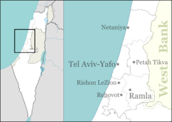
Tel Mond (Template:Lang-he) is a town in the Sharon region of Israel, located east of Netanya and north of Kfar Saba. In 2022 it had a population of 14,477.[1].
History
Before the 20th century, the area of Tel Mond formed part of the Forest of Sharon, a hallmark of the region's historical landscape. It was an open woodland dominated by Mount Tabor Oak (Quercus ithaburensis), which extended from Kfar Yona in the north to Ra’ananna in the south. The local inhabitants traditionally used the area for pasture, firewood and intermittent cultivation. The intensification of settlement and agriculture in the coastal plain during the 19th century under the Ottoman Empire rule led to deforestation and subsequent environmental degradation.[2]
Tel Mond was founded on 16 June 1929 by Alfred Mond, 1st Baron Melchett. Lord Melchett was a British industrialist, a former cabinet minister and president of the British Zionist Foundation. The Palestine Plantations Company, headed by Mond, purchased land in the region and planted citrus orchards to provide employment for Jewish laborers.[3][4] In 1933, a group of farmers purchased land from the company and established moshav Tel Mond. In 1936, another group established moshav Kfar Ziv, named after Baron Sieff who followed Lord Melchett and settled in Tel Mond with his wife. In 1943, new immigrants from Yemen established Shechunat Ya'akov. The surrounding moshavim, Kfar Hess, Herut and Ein Vered, were also founded by the pioneers of Tel Mond.[5]
Between 11 December 1949 and 10 June 1954, Tel Mond was a regional council, encompassing the villages of Herut, Kfar Hess, Ein Vered, Kfar Yavetz, Kfar Ziv, Shechunat Ya'akov, Bnei Dror, Mishmeret, as well as Tel Mond proper.[6] In the 1950s, Neve Oved and Hadar Hayim were built to accommodate the large wave of immigration (mainly from Yemen) after the founding of the state. In 1954, these communities were merged to form the Local Council of Tel Mond.[3]
Over the 2010s, the community has grown from a small town to a self-sufficient mini-city that provides services for other regional communities. It is growing rapidly, and is expected to have a population exceeding 25,000 in 2030.[7]
In June 2013, Kehillat Mevaser Zion, a Modern Orthodox Community in Tel Mond, held an inauguration ceremony for the newly built Synagogue, attended by Naftali Bennett, the Minister for the Economy.
-
Tel Mond 1935
-
Tel Mond 1942 1:20,000
-
Tel Mond 1945 1:250,000
-
Members of Eitanim building defences Tel Mond, 1947
-
Eitanim workers Tel Mond 1947
Landmarks
The home of Lord Melchett has been turned into a museum, named House of the Lord. The museum documents the history of Tel Mond.[5] The museum has a statue of Lord Melchett, designed by Batya Lishansky, located outside the house.[5]
Notable residents
- Bart Berman, pianist and composer
- Avraham Hirschson, former Finance Minister
- Imanuel Rosen, journalist and television personality
- Yehoshua Sobol, playwright and theater director
- Maya Tahan (born 1999), tennis player
- Udi Segal, news anchor
Twin towns
References
- ^ a b "Regional Statistics". Israel Central Bureau of Statistics. Retrieved 21 March 2024.
- ^ Marom, Roy (2022-12-01). "יער השרון (אל-ע'אבה) בתקופה העות'מאנית: בתקופה מהמחקר חדשות תובנות הגיאוגרפי-היסטורי The Oak Forest of the Sharon (al-Ghaba) in the Ottoman Period: New Insights from Historical- Geographical Studies". Muse. 5: 90–107.
- ^ a b "Tel Mond (Israel)". CRW Flags. Retrieved 24 January 2014.
- ^ "Tel Mond". Encyclopaedia Judaica. Vol. 19 (2 ed.). Thomson Gale. 2007. p. 597.
- ^ a b c "A day in the country – Haaretz – Israel News". Archived from the original on 2017-10-20. Retrieved 2022-07-22.
- ^ אבי-הר שגיא, ed. (1991). האנציקלופדיה לשלטון המקומי בישראל. Vol. מועצות מקומיות ב'. Beersheba: הר-שגיא.
- ^ "Part 2 – Central Israel's fastest growing communities".
- ^ "Tel Mond, Israel". Sarasota Sister Cities Association. Archived from the original on 2019-05-03. Retrieved 2014-01-24.


