Vágar Municipality: Difference between revisions
Appearance
Content deleted Content added
m →top: WP:CHECKWIKI error fixes using AWB (12016) |
m [[replace {lang-??} templates with {langx|??} [[Wikipedia:Templates_for_discussion/Log/2024_September_27#Replace_and_delete_lang-??_templates|‹See Tfd›]] (Replaced 1); |
||
| (19 intermediate revisions by 11 users not shown) | |||
| Line 1: | Line 1: | ||
{{Expand Danish|date=January 2022|topic=geo}} |
|||
{{Infobox settlement |
{{Infobox settlement |
||
|name= Vágar Municipality |
|name = Vágar Municipality |
||
|native_name = Vága kommuna |
|native_name = {{native name|fo|Vága kommuna}} |
||
|image_map = Map-position-vaga-kommuna-2009.png |
|image_map = Map-position-vaga-kommuna-2009.png |
||
|image_blank_emblem = Logo of Vága Kommuna, Faroe Islands.svg |
|||
| ⚫ | |||
|blank_emblem_size = 200px |
|||
|mapsize = 250px |
|mapsize = 250px |
||
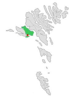
|map_caption = Location of Sandavágar within Vágar Municipality in the Faroe Islands |
|map_caption = Location of Sandavágar within Vágar Municipality in the Faroe Islands |
||
|seat_type = Administrative centre |
|seat_type = Administrative centre |
||
|seat = [[Sandavágur]] |
|seat = [[Sandavágur]] |
||
|area_total_km2 = 102 |
|area_total_km2 = 102.8 |
||
|population_total = |
|population_total = 2198 |
||
|population_footnotes = <ref>[https://hagstova.fo/en/population/population/population Population, municipalities and villages] Statistics Faroe Islands</ref> |
|||
| ⚫ | |||
| |
|population_as_of = January 2024 |
||
|population_density_km2 = auto |
|||
|website = {{URL|http://www.vaga.fo}} |
|||
}} |
}} |
||
'''Vágar Municipality''' (Vága kommuna) is a municipality in the [[Faroese Islands]]. |
'''Vágar Municipality''' ({{langx|fo|Vága kommuna}}) is a municipality in the [[Faroese Islands]]. |
||
It covers the eastern part of the island of [[Vágar]] (while [[Sørvágur Municipality]] covers the western part of the island). |
It covers the eastern part of the island of [[Vágar]] (while [[Sørvágur Municipality]] covers the western part of the island). |
||
| Line 22: | Line 28: | ||
{{coord|62|03|04|N|7|11|38|W|type:city(15000)_source:kolossus-eswiki|display=title}} |
{{coord|62|03|04|N|7|11|38|W|type:city(15000)_source:kolossus-eswiki|display=title}} |
||
==References== |
|||
{{Reflist}} |
|||
{{DEFAULTSORT:Vagar Municipality}} |
{{DEFAULTSORT:Vagar Municipality}} |
||
Latest revision as of 16:23, 6 November 2024
You can help expand this article with text translated from the corresponding article in Danish. (January 2022) Click [show] for important translation instructions.
|
Vágar Municipality
Vága kommuna (Faroese) | |
|---|---|
 Location of Sandavágar within Vágar Municipality in the Faroe Islands | |
| Administrative centre | Sandavágur |
| Area | |
• Total | 102.8 km2 (39.7 sq mi) |
| Population (January 2024)[1] | |
• Total | 2,198 |
| • Density | 21/km2 (55/sq mi) |
| Website | www |
Vágar Municipality (Faroese: Vága kommuna) is a municipality in the Faroese Islands.
It covers the eastern part of the island of Vágar (while Sørvágur Municipality covers the western part of the island).
It was created on 1 January 2009 by fusing the two municipalities of Miðvágur (including the towns of Miðvágur and Vatnsoyrar) and Sandavágur (including the town of Sandavágur).
62°03′04″N 7°11′38″W / 62.05111°N 7.19389°W
References
[edit]- ^ Population, municipalities and villages Statistics Faroe Islands
