

Washington Crossing, Pennsylvania: Difference between revisions
47thPennVols (talk | contribs) Imroved lede, added new section headers in preparation for article expansion, began populating with existing content |
Keystone18 (talk | contribs) copyedits to intro |
||
| Line 72: | Line 72: | ||
<!-- Area/postal codes & others --> |
<!-- Area/postal codes & others --> |
||
|postal_code_type = [[ZIP |
|postal_code_type = [[ZIP Code]] |
||
|postal_code = 18977 |
|postal_code = 18977 |
||
|area_code = [[Area codes 215, 267, and 445|215, 267, and 445]] |
|area_code = [[Area codes 215, 267, and 445|215, 267, and 445]] |
||
| Line 82: | Line 82: | ||
|footnotes = |
|footnotes = |
||
}} |
}} |
||
'''Washington Crossing''' is an [[Unincorporated area|unincorporated]] village located in [[Upper Makefield Township, Bucks County, Pennsylvania |
'''Washington Crossing''' is an [[Unincorporated area|unincorporated]] village located in [[Upper Makefield Township, Bucks County, Pennsylvania|Upper Makefield Township, Pennsylvania]]. Formerly known as "Taylorsville," it is most famous for [[George Washington's crossing of the Delaware River]] on the night of December 25–26, 1776, during the [[American Revolutionary War|American Revolution]]. |
||
The headquarters of [[Washington Crossing Historic Park]] is also located in Washington Crossing, Pennsylvania. The village is connected by [[Washington Crossing Bridge]] with [[Washington Crossing, New Jersey]], which is located on the eastern side of the [[Delaware River]]. |
|||
==Geography== |
==Geography== |
||
Revision as of 16:10, 18 March 2023
Washington Crossing, Pennsylvania | |
|---|---|
Unincorporated community | |
 McConkey's Ferry Inn in 2014 | |
 Washington Crossing  Washington Crossing | |
| Coordinates: 40°17′36″N 74°52′14″W / 40.29333°N 74.87056°W | |
| Country | United States |
| State | Pennsylvania |
| County | Bucks |
| Township | Upper Makefield |
| Elevation | 56 ft (17 m) |
| Time zone | UTC-5 (Eastern (EST)) |
| • Summer (DST) | UTC-4 (EDT) |
| ZIP Code | 18977 |
| Area code(s) | 215, 267, and 445 |
| GNIS feature ID | 1190624[1] |
Washington Crossing is an unincorporated village located in Upper Makefield Township, Pennsylvania. Formerly known as "Taylorsville," it is most famous for George Washington's crossing of the Delaware River on the night of December 25–26, 1776, during the American Revolution.
The headquarters of Washington Crossing Historic Park is also located in Washington Crossing, Pennsylvania. The village is connected by Washington Crossing Bridge with Washington Crossing, New Jersey, which is located on the eastern side of the Delaware River.
Geography
The Delaware Canal, a 60-mile (97 km) long towpath from Easton to Bristol, runs through Washington Crossing Historic Park.
Special events
The town also participates in special events, such as a reenactment of Washington's nighttime crossing each year.[2] Its ZIP Code is 18977.
Points of interest
Gallery
-
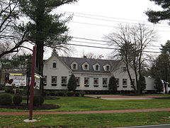 Washington Crossing Inn
 -
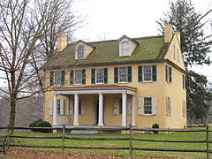 Mahlon K. Taylor house
 -


References
- ^ "Washington Crossing". Geographic Names Information System. United States Geological Survey, United States Department of the Interior.
- ^ "Cross With Us". Washington Crossing Historic Park.
External links

| International | |
|---|---|
| National | |