Passani
Appearance
This article needs additional citations for verification. (August 2013) |
Passani
پاسنى | |
|---|---|
| Coordinates: 33°45′48.61″N 71°35′30.81″E / 33.7635028°N 71.5918917°E | |
| Country | |
| Province | Khyber Pakhtunkhwa |
| District | Peshawar District |
| Tehsil | Peshawar Tehsil |
| Union council | Maryam Zai |
| Area | |
• Total | 3.0 km2 (1.2 sq mi) |
| Population (1998) | |
• Total | 3,000 |
• Estimate (2015) | 6,000 |
| Time zone | UTC+5 (PST) |
| Calling code | 091 |
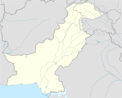
Passani (Urdu: پاسنى) is a village located 33 km south of Peshawar, Khyber Pakhtunkhwa, Pakistan.[1][2]
Education
[edit]The village has three primary schools: one for boys and two for girls, a middle school for boys, and a high school for girls. The literacy rate is 80% for men and 50% for women.
Economy
[edit]The main professions of the people are farming, government jobs and small businesses. Likewise, Passani is a business hub for the surrounding areas of Adezai, Sherkera, Kandao, Hasankhel, Janakod, Bora, Pastawone, Aratbaba, Yarankhel, and Miaghadi.
References
[edit]- ^ "Government of Pakistan Official Webpage". Library of Congress, Washington, D.C. 20540 USA. Retrieved 2022-10-27.
- ^ "The Official Web Gateway to Pakistan". pakistan.gov.pk. Retrieved 2022-10-27.

