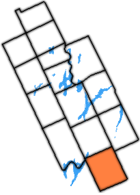
File:Victoria county with manvers highlighted.png
From Infogalactic: the planetary knowledge core
Victoria_county_with_manvers_highlighted.png (205 × 285 pixels, file size: 28 KB, MIME type: image/png)
Summary
| Description |
Map of Victoria County (Now city of Kawartha Lakes), with former township of Manvers highlighted in orange. |
|---|---|
| Source |
I created this work entirely by myself with gimp. |
| Date |
08:01, 17 July 2009 (UTC) |
| Author | |
| Permission (Reusing this file) |
See below. |
| Other versions | *File:Victoria_county_with_bexley_highlighted.png
|
Lua error in package.lua at line 80: module 'strict' not found.
Licensing:
|
I, the copyright holder of this work, hereby publish it under the following licenses:
Lua error in package.lua at line 80: module 'strict' not found. Lua error in package.lua at line 80: module 'strict' not found.
You may select the license of your choice.
|
File history
Click on a date/time to view the file as it appeared at that time.
| Date/Time | Thumbnail | Dimensions | User | Comment | |
|---|---|---|---|---|---|
| current | 22:34, 16 January 2017 |  | 205 × 285 (28 KB) | 127.0.0.1 (talk) | Map of Victoria County (Now city of <a href="https://en.wikipedia.org/wiki/Kawartha_Lakes" class="extiw" title="en:Kawartha Lakes">Kawartha Lakes</a>), with former township of Manvers highlighted in orange. |
- You cannot overwrite this file.
File usage
The following page links to this file:
