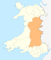
File:Wales Powys locator map.svg
From Infogalactic: the planetary knowledge core

Size of this PNG preview of this SVG file: 502 × 600 pixels. Other resolution: 201 × 240 pixels.
Original file (SVG file, nominally 1,047 × 1,251 pixels, file size: 153 KB)
Summary
Locator map of Powys in Wales
Licensing
Lua error in package.lua at line 80: module 'strict' not found.
File history
Click on a date/time to view the file as it appeared at that time.
| Date/Time | Thumbnail | Dimensions | User | Comment | |
|---|---|---|---|---|---|
| current | 08:12, 3 January 2017 |  | 1,047 × 1,251 (153 KB) | 127.0.0.1 (talk) | Locator map of Powys in Wales |
- You cannot overwrite this file.
File usage
More than 100 pages link to this file. The following list shows the first 100 page links to this file only. A full list is available.
- A40 road
- A44 road
- A470 road
- A483 road
- A487 road
- Abbeycwmhir
- Aber Clydach
- Abercegir
- Abercraf
- Aberedw
- Abergwesyn
- Abergwydol
- Aberhafesp
- Aberhosan
- Aberyscir
- Adfa, Powys
- Afon Crai
- Afon Cynrig
- Afon Tanat
- Afon Twrch
- B4574 road
- Berriew
- Bettws Cedewain
- Boughrood
- Brecon
- Builth Road railway station
- Builth Wells
- Burgedin
- Buttington
- Caersws
- Capel-y-ffin
- Carno
- Cefnllys
- Church Stoke
- Cilmeri
- Cilmeri railway station
- Clatter
- Crickhowell
- Crug Hywel
- Dolau railway station
- Dolfach
- Dylife
- Elan Valley Reservoirs
- Epynt Way
- Fan y Big
- Ffrwd Fawr Waterfall
- Forge, Powys
- Four Crosses, Powys
- Garreg Lwyd (Rhayader)
- Gladestry
- Glyndŵr's Way
- Gyrn Moelfre
- Hay-on-Wye
- Heol Senni
- Knighton, Powys
- Llan, Powys
- Llandrindod Wells
- Llandrindod railway station
- Llandrinio
- Llangammarch
- Llangammarch Wells
- Llangurig
- Llanidloes
- Llanrhaeadr-ym-Mochnant
- Llansantffraed
- Llanwrtyd
- Llanwrtyd Wells
- Llanyre
- Machynlleth
- Montgomery, Powys
- Nant Gwys
- New Radnor
- Offa's Dyke Path
- Pegwn Mawr
- Pen-y-Bont railway station
- Penegoes
- Penybont
- Pipton
- Pistyll y Llyn
- Pontdolgoch
- Pontrobert
- Powis Castle
- Powys
- Presteigne
- Radnor Forest
- Rhayader
- Rhos Fawr
- River Carno
- River Haffes
- River Vyrnwy
- Sarn Helen
- St Harmon
- Sycharth
- Talerddig
- Talgarth
- Three Cocks
- Welshpool
- Welshpool and Llanfair Light Railway
- Wye Valley Walk
- Ystradfellte