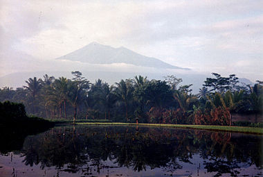
Mount Merbabu
| Mount Merbabu | |
|---|---|

Mt Merbabu viewed from Salatiga
|
|
| Highest point | |
| Elevation | Lua error in Module:Convert at line 1851: attempt to index local 'en_value' (a nil value). [1] |
| Prominence | Lua error in Module:Convert at line 1851: attempt to index local 'en_value' (a nil value). [1] |
| Listing | Ultra Ribu |
| Coordinates | Lua error in package.lua at line 80: module 'strict' not found. [1] |
| Naming | |
| Translation | Mountain of ash (Indonesian) |
| Geography | |
| Geology | |
| Mountain type | Dormant stratovolcano |
| Last eruption | 1797 |
| Climbing | |
| Easiest route | Hike starting near Kopeng |
Mount Merbabu (Indonesian: Gunung Merbabu) is a dormant stratovolcano in Central Java province on the Indonesian island of Java. The name Merbabu could be loosely translated as 'Mountain of Ash' from the Javanese combined words; Meru means "mountain" and awu or abu means "ash".
The active volcano Mount Merapi is directly adjacent on its south-east side, while the city of Salatiga is located on its northern foothills. A 1,500m high broad saddle lies between Merbabu and Merapi,[2] the site of the village of Selo and highly fertile[citation needed] farming land.
There are two peaks; Syarif (3,119 m) and Kenteng Songo (3,145 m). Three U-shaped radial valleys extend from the Kenteng Songo summit in northwesterly, northeastly and southeastly directions.
Two known moderate eruptions occurred in 1560 and 1797. The 1797 event was rated 2: Explosive, on the Volcanic Explosivity Index.[3] An unconfirmed eruption may have occurred in 1570.[4]
Geologically recent eruptions originated from a North Northwest-South Southeast fissure system that cut across the summit and fed the large-volume lava flows from Kopeng and Kajor craters on the northern and southern flanks, respectively.[2]
Merbabu can be climbed from several routes originating from the town of Kopeng on the north east sideside, and also from Selo on the southern side. A climb from Kopeng to Kenteng Songo takes between 8 and 10 hours.[citation needed]
An area of 57 km² at the mountain has been declared a national park in 2004.[5]
See also
References
- ↑ 1.0 1.1 1.2 "Mountains of the Indonesian Archipelago" Peaklist.org. Retrieved 2012-06-23.
- ↑ 2.0 2.1 Global Volcanism Program | Merbabu | Summary. Volcano.si.edu. Retrieved on 2010-11-05.
- ↑ Global Volcanism Program | Merbabu | Eruptive History. Volcano.si.edu. Retrieved on 2010-11-05.
- ↑ Simkin, T., and Siebert, L., 1994, Volcanoes of the World: Geoscience Press, Tucson, Arizona, 349 p.
- ↑ Lestari Hutan Indonesia. Retrieved 26 February 2010.
External links
- Articles containing Indonesian-language text
- Articles with unsourced statements from June 2009
- Pages with broken file links
- Mountains of Java
- Stratovolcanoes of Indonesia
- Subduction volcanoes
- Volcanoes of Java
- Landforms of Central Java
- National parks of Indonesia
- Mount Merapi
- Visitor attractions in Central Java
