Bloubergstrand
Appearance
| Bloubergstrand | |
|---|---|
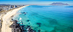
 An aerial view of Bloubergstand with Table Mountain on the far side of Table Bay. | |
|
Location within Cape Town Lua error in Module:Location_map at line 417: Unable to find the specified location map definition. Neither "Module:Location map/data/Cape Town" nor "Template:Location map Cape Town" exists. | |
| Coordinates: 33°47′50″S 18°27′43″E / 33.7972°S 18.4620°E | |
| Naga | Afrika Borwa |
| Porofense | Kapa Bodikela |
| Mmušôselegae | City of Cape Town Metropolitan Municipality|City of Cape Town |
| Sekgôba[1] | |
| • Total | 1.39 km2 (0.54 sq mi) |
| Setšhaba (2011)[1] | |
| • Total | 2,133 |
| • Phitlaganyo | 1,500/km2 (4,000/sq mi) |
| Nomoro ya poso (Setarata) | 7441 |
| Nomoro ya poso (Lepokisi) | 7436 |
| Khoutu ya lefelo | 021 |
Bloubergstrand ke motsesetoropo leboa la Cape Town.
Ditšhupetšo
[lokiša | edit source]- ↑ 1.0 1.1 1.2 1.3 "Sub Place Bloubergstrand". Census 2011.

