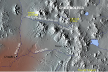
Toconce River (Q738039): Difference between revisions
Jump to navigation
Jump to search
Added reference to claim: image (P18): Río-loa-(origen).svg |
Quesotiotyo (talk | contribs) Created claim: GNS Unique Feature ID (P2326): -902874, batch #227537 |
||||||||||
| (31 intermediate revisions by 22 users not shown) | |||||||||||
| label / sv | label / sv | ||||||||||
Río Toconce | |||||||||||
| label / ceb | label / ceb | ||||||||||
Río Toconce | |||||||||||
| label / cy | label / cy | ||||||||||
Afon Toconce | |||||||||||
| label / ga | label / ga | ||||||||||
Abhainn Toconce | |||||||||||
| label / vec | label / vec | ||||||||||
Fiume Toconce | |||||||||||
| label / ast | label / ast | ||||||||||
Ríu Toconce | |||||||||||
| aliases / es / 0 | aliases / es / 0 | ||||||||||
Rio Toconce | |||||||||||
| description / en | description / en | ||||||||||
river in Chile | |||||||||||
| description / nl | description / nl | ||||||||||
rivier in Chili | |||||||||||
| description / he | description / he | ||||||||||
נהר | |||||||||||
| description / ar | description / ar | ||||||||||
نهر | |||||||||||
| description / bn | description / bn | ||||||||||
চিলির নদী | |||||||||||
| description / de | description / de | ||||||||||
Fluss in Chile | |||||||||||
| description / uk | description / uk | ||||||||||
річка в Чилі | |||||||||||
| description / ga | description / ga | ||||||||||
abhainn sa tSile | |||||||||||
| Property / instance of: river / reference | |||||||||||
| Property / country | |||||||||||
| Property / country: Chile / rank | |||||||||||
Normal rank | |||||||||||
| Property / country: Chile / reference | |||||||||||
| Property / GeoNames ID | |||||||||||
| Property / GeoNames ID: 3869720 / rank | |||||||||||
Normal rank | |||||||||||
| Property / GeoNames ID: 3869720 / reference | |||||||||||
| Property / mouth of the watercourse | |||||||||||
| Property / mouth of the watercourse: Salado River (Loa) / rank | |||||||||||
Normal rank | |||||||||||
| Property / mouth of the watercourse: Salado River (Loa) / reference | |||||||||||
| Property / coordinate location | |||||||||||
-22° 16' 45.95", -68° 12' 46.12"
| |||||||||||
| Property / coordinate location: 22°16'45.95"S, 68°12'46.12"W / rank | |||||||||||
Normal rank | |||||||||||
| Property / coordinate location: 22°16'45.95"S, 68°12'46.12"W / reference | |||||||||||
| Property / OpenStreetMap relation ID | |||||||||||
| Property / OpenStreetMap relation ID: 9821949 / rank | |||||||||||
Normal rank | |||||||||||
| Property / drainage basin | |||||||||||
| Property / drainage basin: Loa Basin / rank | |||||||||||
Normal rank | |||||||||||
| Property / Commons category | |||||||||||
Toconce River | |||||||||||
| Property / Commons category: Toconce River / rank | |||||||||||
Normal rank | |||||||||||
| Property / located in the administrative territorial entity | |||||||||||
| Property / located in the administrative territorial entity: Antofagasta Region / rank | |||||||||||
Normal rank | |||||||||||
| Property / origin of the watercourse | |||||||||||
| Property / origin of the watercourse: Cerro Toconce / rank | |||||||||||
Normal rank | |||||||||||
| Property / Freebase ID | |||||||||||
| Property / Freebase ID: /m/06w6y2m / rank | |||||||||||
Normal rank | |||||||||||
| Property / GNS Unique Feature ID | |||||||||||
| Property / GNS Unique Feature ID: -902874 / rank | |||||||||||
Normal rank | |||||||||||
| links / svwiki / name | links / svwiki / name | ||||||||||
| links / cebwiki / name | links / cebwiki / name | ||||||||||
| links / commonswiki / name | links / commonswiki / name | ||||||||||
Latest revision as of 09:06, 7 April 2024
river in Chile
| Language | Label | Description | Also known as |
|---|---|---|---|
| English | Toconce River |
river in Chile |
Statements
Identifiers
Sitelinks
Wikipedia(5 entries)
- cebwiki Río Toconce
- enwiki Toconce River
- eswiki Río Toconce
- kawiki ტოკონსე
- svwiki Río Toconce
Wikibooks(0 entries)
Wikinews(0 entries)
Wikiquote(0 entries)
Wikisource(0 entries)
Wikiversity(0 entries)
Wikivoyage(0 entries)
Wiktionary(0 entries)
Multilingual sites(1 entry)
- commonswiki Category:Toconce River

