费尔南多·迪诺罗尼亚群岛:修订间差异
外观
删除的内容 添加的内容
补救2个来源,并将0个来源标记为失效。 #IABot (v1.4.2) |
// Edit via Wikiplus 标签:Wikiplus |
||
| (未显示8个用户的14个中间版本) | |||
| 第1行: | 第1行: | ||
{{NoteTA |
|||
|1=zh-cn:费尔南多; zh-hk:費南度; zh-tw:費南多; |
|||
|2=zh-cn:伯南布哥; zh-tw:伯南布科; |
|||
}} |
|||
{{Infobox islands |
{{Infobox islands |
||
| name = 费尔南多·迪诺罗尼亚群岛<br><small>{{lang|pt|Fernando de Noronha Archipelago}}</small> |
| name = 费尔南多·迪诺罗尼亚群岛<br><small>{{lang|pt|Fernando de Noronha Archipelago}}</small> |
||
| 第69行: | 第73行: | ||
| ethnic groups = |
| ethnic groups = |
||
| additional info = |
| additional info = |
||
| website = |
| website = {{URL|https://www.Noronha.pe.gov.br}} |
||
}} |
}} |
||
| 第83行: | 第87行: | ||
|site_img_width = |
|site_img_width = |
||
|country = {{BRA}} |
|country = {{BRA}} |
||
| |
|Region = 拉丁美洲和加勒比地区 |
||
|area = |
|area = |
||
|criterion_n = (ix)(x) |
|criterion_n = (ix)(x) |
||
| 第100行: | 第104行: | ||
|locmapin = Brazil |
|locmapin = Brazil |
||
|relief = |
|relief = |
||
|latitude = -3.85794444 |
|||
|longitude = -32.42511111 |
|||
|map_caption = 巴西國立费尔南多·迪诺罗尼亚海洋公園在[[巴西]]的位置 |
|map_caption = 巴西國立费尔南多·迪诺罗尼亚海洋公園在[[巴西]]的位置 |
||
}} |
}} |
||
[[大西洋|南大西洋]]露出海面的[[海底山脈]]形成了費爾南多·迪諾羅尼亞群島,以及隣近的[[羅卡斯環礁]],這裡代表了南大西洋大部分島嶼,富饒的海域,對[[鮪魚]]、[[鯊]]、[[海龜]]和其他[[海洋哺乳動物]]的生長和繁衍都極為重要,而島嶼則是西大西洋熱帶[[海鳥]]的最大[[棲息地]]。在拜亞海域({{lang|pt|Baía dos Golfinhos}})有大量的[[海豚]]在活動,在[[潮汐|退潮]]時,羅卡斯環礁組成一幅海岸美景,散布著蓄有豐富魚類的[[ |
[[大西洋|南大西洋]]露出海面的[[海底山脈]]形成了費爾南多·迪諾羅尼亞群島,以及隣近的[[羅卡斯環礁]],這裡代表了南大西洋大部分島嶼,富饒的海域,對[[鮪魚]]、[[鯊]]、[[海龜]]和其他[[海洋哺乳動物]]的生長和繁衍都極為重要,而島嶼則是西大西洋熱帶[[海鳥]]的最大[[棲息地]]。在拜亞海域({{lang|pt|Baía dos Golfinhos}})有大量的[[海豚]]在活動,在[[潮汐|退潮]]時,羅卡斯環礁組成一幅海岸美景,散布著蓄有豐富魚類的[[潟湖]]和潮水潭<ref name=UNESCO/>。 |
||
=== 登録基準 === |
=== 登録基準 === |
||
| 第113行: | 第115行: | ||
{{reflist|1|refs= |
{{reflist|1|refs= |
||
<ref name='IBGE2012'> |
<ref name='IBGE2012'>{{cite web |url=http://cidades.ibge.gov.br/xtras/temas.php?codmun=260545&idtema=75 |title=IBGE - Cidades - Pernambuco - Fernando de Noronha - Estimativa da População - 2012 |accessdate=2013-10-20 |author=IBGE (Brazilian Institute of Geography and Statistics) |authorlink=http://www.ibge.gov.br |date=2012 |language=pt |deadurl=yes |archiveurl=https://web.archive.org/web/20131022125910/http://cidades.ibge.gov.br/xtras/temas.php?codmun=260545&idtema=75 |archivedate=2013-10-22 }}</ref> |
||
<ref name=UNESCO>{{cite web |url=http://whc.unesco.org/en/list/1000/ |title=Brazilian Atlantic Islands: Fernando de Noronha and Atol das Rocas Reserves |publisher=UNESCO |language=en |accessdate=2013-12-03}}</ref> |
<ref name=UNESCO>{{cite web |url=http://whc.unesco.org/en/list/1000/ |title=Brazilian Atlantic Islands: Fernando de Noronha and Atol das Rocas Reserves |publisher=UNESCO |language=en |accessdate=2013-12-03 |archive-date=2021-05-02 |archive-url=https://web.archive.org/web/20210502043024/https://whc.unesco.org/en/list/1000 |dead-url=no }}</ref> |
||
}} |
}} |
||
* http://www.noronha.info/ |
* http://www.noronha.info/ {{Wayback|url=http://www.noronha.info/ |date=20100926220534 }} |
||
* http://www.airtrip.com.br/ |
* http://www.airtrip.com.br/{{Wayback|url=http://www.airtrip.com.br/ |date=20080511194719 }} |
||
* https://web.archive.org/web/20050523235951/http://www.noronha.pe.gov.br/ |
* https://web.archive.org/web/20050523235951/http://www.noronha.pe.gov.br/ |
||
* http://www.ilhadenoronha.com.br/ |
* http://www.ilhadenoronha.com.br/ {{Wayback|url=http://www.ilhadenoronha.com.br/ |date=20210503144144 }} |
||
== 外部链接 == |
== 外部链接 == |
||
{{Commons category}} |
|||
{{sisterlinks|Fernando de Noronha}} |
|||
* {{en icon}} [http://www.pvv.org/~bct/brasil2/noronha.html A photo tour of the island] |
* {{en icon}} [http://www.pvv.org/~bct/brasil2/noronha.html A photo tour of the island] {{Wayback|url=http://www.pvv.org/~bct/brasil2/noronha.html |date=20210415194747 }} |
||
* {{en icon}} [http://islandsbrazil.blogspot.com Site about islands in Brazil] |
* {{en icon}} [http://islandsbrazil.blogspot.com Site about islands in Brazil] {{Wayback|url=http://islandsbrazil.blogspot.com/ |date=20210505002154 }} |
||
* {{en icon}} [http://www.fernando-de-noronha.org Information in English about Noronha] |
* {{en icon}} [https://web.archive.org/web/20200509132902/http://www.fernando-de-noronha.org/ Information in English about Noronha] |
||
* {{en icon}}/{{de icon}} [http://www.fernando-de-noronha.info Tourist information provided by a local resident] |
* {{en icon}}/{{de icon}} [https://web.archive.org/web/20120310013913/http://www.fernando-de-noronha.info/ Tourist information provided by a local resident] |
||
* {{en icon}} [http://www.worldwildlife.org/wildworld/profiles/terrestrial/nt/nt0123_full.html Fernando de Noronha-Atol das Rocas moist forests (WWF)] |
* {{en icon}} [http://www.worldwildlife.org/wildworld/profiles/terrestrial/nt/nt0123_full.html Fernando de Noronha-Atol das Rocas moist forests (WWF)] {{Wayback|url=http://www.worldwildlife.org/wildworld/profiles/terrestrial/nt/nt0123_full.html |date=20111121141457 }} |
||
* {{en icon}} [http://www.ulivewhere.com/low/downloads/download-fernandodenoronha.html Audio interview with Fernando de Noronha resident about life on Fernando de Noronha] |
* {{en icon}} [https://web.archive.org/web/20070928025158/http://www.ulivewhere.com/low/downloads/download-fernandodenoronha.html Audio interview with Fernando de Noronha resident about life on Fernando de Noronha] |
||
{{巴西世界遗产}} |
{{巴西世界遗产}} |
||
| 第142行: | 第144行: | ||
[[Category:前法國殖民地]] |
[[Category:前法國殖民地]] |
||
[[Category:海洋國家公園]] |
[[Category:海洋國家公園]] |
||
[[Category:巴西生態區域]] |
|||
[[Category:陸地生態區域]] |
|||
[[Category:海洋生態區域]] |
|||
[[Category:淡水生態區域]] |
|||
[[Category:新熱帶界生態區域]] |
|||
2024年10月9日 (三) 10:24的最新版本
| 费尔南多·迪诺罗尼亚群岛 Fernando de Noronha Archipelago | |
|---|---|
Arquipélago de Fernando de Noronha | |
 群島的最高點摩羅峰與週邊海灘 | |
 | |
| 地理 | |
 | |
| 位置 | 大西洋 |
| 坐标 | 3°51′13.71″S 32°25′25.63″W / 3.8538083°S 32.4237861°W |
| 群岛 | 费尔南多·迪诺罗尼亚群岛 |
| 总岛屿 | 21 |
| 主要島嶼 | Fernando de Noronha; Ilha Rata; Ilha do Meio; Ilha Sela Gineta; Ilha Rasa |
| 面積 | 26平方公里(10平方英里) |
| 长度 | 10千米(6英里) |
| 宽度 | 3.5千米(2.17英里) |
| 最高海拔 | 323米(1060英尺) |
| 最高點 | 摩羅峰(Morro do Pico) |
| 管轄 | |
| 地區 | 東北部 |
| 州 | 伯南布哥 |
| 最大 | 雷梅迪奧斯村(Vila dos Remédios) |
| 人口统计 | |
| 人口 | 2,718[1](2012) |
| 其他资料 | |
| 官方網站 | www |
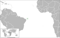
费尔南多·迪诺罗尼亚群岛(葡萄牙語:Fernando de Noronha),是巴西伯南布哥州辖下的一个群岛,位于伯南布哥州海岸外354公里的大西洋中。该群岛由21个岛屿组成,主岛面积18.4平方公里,人口3012人(2010年)。2001年被列入世界自然遗产。
世界遺產
[编辑]| 世界遗产 | |
|---|---|
 兩兄弟島(Dois Irmãos) | |
| 官方名稱 | Brazilian Atlantic Islands: Fernando de Noronha and Atol das Rocas Reserves(英文) Îles atlantiques brésiliennes : les Réserves de Fernando de Noronha et de l'atol das Rocas(法文) |
| 位置 | |
| 標準 | 自然:(ix)(x) |
| 参考编码 | 1000 |
| 登录年份 | 2001年(第25屆會議) |
| 坐标 | 3°51′28.6″S 32°25′30.40″W / 3.857944°S 32.4251111°W |
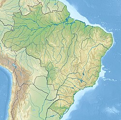
巴西國立费尔南多·迪诺罗尼亚海洋公園在巴西的位置 | |
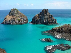
南大西洋露出海面的海底山脈形成了費爾南多·迪諾羅尼亞群島,以及隣近的羅卡斯環礁,這裡代表了南大西洋大部分島嶼,富饒的海域,對鮪魚、鯊、海龜和其他海洋哺乳動物的生長和繁衍都極為重要,而島嶼則是西大西洋熱帶海鳥的最大棲息地。在拜亞海域(Baía dos Golfinhos)有大量的海豚在活動,在退潮時,羅卡斯環礁組成一幅海岸美景,散布著蓄有豐富魚類的潟湖和潮水潭[2]。
登録基準
[编辑]该世界遗产被认为满足世界遺產登錄基準中的以下基準而予以登錄:
- (ix)在陆上、淡水、沿海及海洋生态系统及动植物群的演化与发展上,代表持续进行中的生态学及生物学过程的显著例子。
- (x)拥有最重要及显著的多元性生物自然生态栖息地,包含从保育或科学的角度来看,符合普世价值的濒临绝种动物种。
參考資料
[编辑]- ^ [(Brazilian Institute of Geography and Statistics)]. IBGE - Cidades - Pernambuco - Fernando de Noronha - Estimativa da População - 2012. 2012 [2013-10-20]. (原始内容存档于2013-10-22) (葡萄牙语). 请检查
|author-link1=值 (帮助) - ^ Brazilian Atlantic Islands: Fernando de Noronha and Atol das Rocas Reserves. UNESCO. [2013-12-03]. (原始内容存档于2021-05-02) (英语).
- http://www.noronha.info/ (页面存档备份,存于互联网档案馆)
- http://www.airtrip.com.br/(页面存档备份,存于互联网档案馆)
- https://web.archive.org/web/20050523235951/http://www.noronha.pe.gov.br/
- http://www.ilhadenoronha.com.br/ (页面存档备份,存于互联网档案馆)
外部链接
[编辑]维基共享资源上的相关多媒体资源:费尔南多·迪诺罗尼亚群岛
- (英文) A photo tour of the island (页面存档备份,存于互联网档案馆)
- (英文) Site about islands in Brazil (页面存档备份,存于互联网档案馆)
- (英文) Information in English about Noronha
- (英文)/(德文) Tourist information provided by a local resident
- (英文) Fernando de Noronha-Atol das Rocas moist forests (WWF) (页面存档备份,存于互联网档案馆)
- (英文) Audio interview with Fernando de Noronha resident about life on Fernando de Noronha

