Category:Quercus distribution maps
Jump to navigation
Jump to search
Subcategories
This category has the following 63 subcategories, out of 63 total.
- Quercus alba range maps (7 F)
A
B
C
D
F
G
I
K
L
M
N
- Quercus nigra range maps (6 F)
P
R
- Quercus robur range maps (2 F)
- Quercus rubra range maps (8 F)
S
- Quercus suber range maps (3 F)
T
V
W
Pages in category "Quercus distribution maps"
This category contains only the following page.
Media in category "Quercus distribution maps"
The following 17 files are in this category, out of 17 total.
-
 NA-savanna-map.gif 579 × 555; 225 KB
-
 Annual report (1909) (14565068358).jpg 2,800 × 2,144; 1.26 MB
-
 Cyclobalanopsis &Quercus range map.png 1,400 × 900; 299 KB
-
 Quercus cerris range.svg 1,512 × 945; 813 KB
-
 Quercus coccifera range.svg 1,418 × 709; 439 KB
-
 Quercus fagineaMap.png 1,357 × 628; 39 KB
-
 Quercus frainetto range.svg 1,418 × 886; 382 KB
-
 Quercus ilex range.svg 1,276 × 886; 804 KB
-
 Quercus inopina range map.png 640 × 640; 89 KB
-
 Quercus petraea - range in Europe by Boratynski.png 1,879 × 1,290; 1,020 KB
-
 Quercus petraea range.svg 1,418 × 850; 921 KB
-
 Quercus pubescens range.svg 1,418 × 850; 826 KB
-
 Quercus pyrenaica range.svg 992 × 886; 158 KB
-
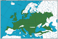
 Quercus robur range.svg 1,418 × 850; 985 KB
-
 Quercus similis.PNG 600 × 600; 90 KB
-
 Quercus trojana range.svg 1,418 × 886; 318 KB
-
 QuercusRobur ZasiegGatunku01.png 1,879 × 1,290; 949 KB


