Halebidu (IAST: Haḷēbīḍ, literally "old capital, city, encampment"[1] or "ruined city"[2]) is a town located in Hassan District, Karnataka, India. Historically known as Dorasamudra or Dwarasamudra, Halebidu was the regal capital of the Hoysala Empire in the 12th century CE. In the modern era literature it is sometimes referred to as Halebeedu or Halebid as the phonetic equivalent, a local name after it was damaged and deserted after being ransacked and looted twice by the forces of the Delhi Sultanate in the 14th century.[3][4][5]
Halebidu
Dorasamudra or Dwarasamudra | |
|---|---|
town | |
 | |
 Halebidu Karnataka, India  Halebidu Halebidu (India) | |
| Coordinates: 13°12′57″N 75°59′29″E / 13.2157°N 75.9914°E | |
| Country | India |
| State | Karnataka |
| District | Hassan district |
| Elevation | 880 m (2,890 ft) |
| Population (2001) | |
| • Total | 8,962 |
| Ethnicity | |
| Time zone | UTC+5:30 (IST) |
| Telephone code | 08172 |
| Website | karnataka |
Halebidu is home to some of the best examples of Hindu and Jain temples with Hoysala architecture. These show the breadth of Hindu artwork traditions – Shiva, Vishnu, Devi and Vedic deities – fused into the same temple complex, depicted with a diversity of regional heritages, along with inscriptions in scripts from South and North India. The Hindu temples include Jaina reliefs in its panel. Similarly, the Jaina artwork includes the different Tirthankara as well as a Saraswati within its mantapa. Most notable among the Halebidu monuments are the ornate Hoysalesvara, Kedareshwara, Jaina Basadi temples, as well as the Hulikere step well (kalyani). These sites are within a kilometer of each other.[6][7][8]
Location
Halebidu is connected by road and rail to Hassan (30 km), Mysore (150 km) and Mangalore (184 km). It is about 15 kilometers from Belur, another site known for its intricately carved Hoysala era temples.
History
Halebidu is in the midst of a valley east of the Western Ghats. It is surrounded by low-lying mountains, boulders and seasonal rivers. This valley is well connected to northern Karnataka, western Andhra Pradesh and northern Tamil Nadu.[9] Around this region, between the 10th and 14th-century, the Hoysaḷa dynasty came to power, whose history is unclear. By their own 11th and 12th-century inscriptions, they were descendants of the Krishna-Baladeva-roots and the Yadavas of eastern Maharashtra. These inscriptions have been questioned as potential mythistory by some historians, who propose that the Hoysalas were a local Hindu family who seized power in the 10th-century.[10]
Halebidu was built anew near a large reservoir by Hoysala kings, with support from their governors, merchants, and artisans. Major and spectacularly carved Hindu and Jain temples were already complete by the 12th-century. Around the city were fort walls, generally tracing a rounded square-like area with an average span of 2.25 kilometers. Inside were four major water reservoirs and many smaller public water tanks. The city life, it major temples and the roads were centered near the Dorasamudra water reservoir. The city several dozen temples, of which only a small set has survived. Three set of temples – Hoysaleswara (twin temple), Jain Basadi (three temples) and Kedareshvara (one temple) – were the largest, more sophisticated in their architecture and artwork, while the rest were simpler.[9]
To the immediate west of the major Hindu and Jain temples was the Hoysala Palace. This palace stretched south up to the Benne Gudda (lit., butter hill). The palace is completely ruined and gone, with section lost in mounds and fragments found near the Benne Gudda. To the west of the palace was another group of Hindu and Jain temples – the Nagaresvara site, also destroyed whose ruins have been found in mounds. To the north of the original Hoysala city was a Saraswati temple and a Krishna temple, both also ruined and mostly lost. Towards the center and south of the old city were Hucesvara temple and a Rudresvara temple, evidenced by inscriptions and ruins that have been discovered. Four temples in northeastern section have survived – Gudlesvara, Virabhadra, Kumbalesvara and Ranganatha. The western part of the fortified section and beyond the fort were the historic farms that fed the population of the Dorasamudra capital. Roads connected the Hoysala capital to other major towns and pilgrimage sites such as Belur and Pushpagiri.[9]
Gallery
-
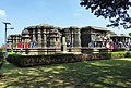 Hoysaleshwara temple, Halebid – the most studied temple in the town
 -
 Hoysaleshwara temple
 -
 One of the three major Jain temples, Halebid
 -
 Kedareshvara temple
 -
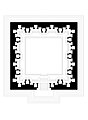
 Floor plan of the Hoysaleshwar temple – a twin temple
 -
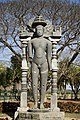 Bahubali monolith at Halebidu
 -
 Ganesha relief in the park
 -
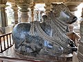 One of the two major Nandis
 -
 Inscriptions in diverse Indian scripts
 -
 Floor plan of the Hulikere water tank built in the 12th-century


See also
References
- ^ JF Fleet, Nele-Vidu: Appayana-Vidu, The Journal of the Royal Asiatic Society of Great Britain and Ireland, Cambridge University Press, pp. 117-119, JSTOR 25189510
- ^ Duraiswamy, S. (2004). The Creative Touches of the Chisel. p. 107. ISBN 978-955-8095-49-2.
- ^ Robert Bradnock; Roma Bradnock (2000). India Handbook. McGraw-Hill. p. 959. ISBN 978-0-658-01151-1.
- ^ Catherine B. Asher (1995). India 2001: Reference Encyclopedia. South Asia. pp. 29–30. ISBN 978-0-945921-42-4.
- ^ Joan-Pau Rubiés (2002). Travel and Ethnology in the Renaissance: South India Through European Eyes, 1250-1625. Cambridge University Press. pp. 13–15. ISBN 978-0-521-52613-5.
- ^ V Bharne; K Krusche (2014). Rediscovering the Hindu Temple: The Sacred Architecture and Urbanism of India. Cambridge Scholars Publishing. pp. 1–17. ISBN 978-1-4438-6734-4.
- ^ "Adinatha Basti, Halebid | ASI Bengaluru Circle".
- ^ Gopal, Madan (1990). K.S. Gautam (ed.). India through the ages. Publication Division, Ministry of Information and Broadcasting, Government of India. p. 178.
- ^ a b c Katherine E. Kasdorf (2013), Forming Dōrasamudra: Temples of the Hoysaḷa Capital in Context, Columbia University Press
- ^ Fischel, F.R.S. (2020). Local States in an Imperial World: Identity, Society and Politics in the Early Modern Deccan. Edinburgh University Press. pp. 34–39. ISBN 978-1-4744-3609-0.
External links
- Sacred Ensembles of the Hoysala – Belur and Halebid, UNESCO World Heritage Sites Pending Application Package
- Hoysalesvara Temple, Halebid, Archaeological Survey of India, Bengaluru Circle
- Parsvanatha Basadi, Halebid, Archaeological Survey of India, Bengaluru Circle
- Kedaresvara Temple, Halebid, Archaeological Survey of India, Bengaluru Circle
- Shantinatha Basadi, Halebid, Archaeological Survey of India, Bengaluru Circle
- Step well, Hulikere Halebid, Archaeological Survey of India, Bengaluru Circle