Białystok-Krywlany Airfield
This article may require copy editing for grammar, style, cohesion, tone, or spelling. (May 2017) |
Białystok-Krywlany Airport | |||||||||||||||||||||||
|---|---|---|---|---|---|---|---|---|---|---|---|---|---|---|---|---|---|---|---|---|---|---|---|
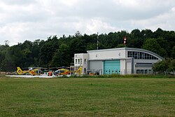
 Podlaskie headquarters of the Air Rescue Service at the airfield | |||||||||||||||||||||||
| Summary | |||||||||||||||||||||||
| Airport type | Public | ||||||||||||||||||||||
| Operator | Aeroklub Polski (Aeroklub Bialystok) | ||||||||||||||||||||||
| Serves | Białystok | ||||||||||||||||||||||
| Location | Białystok, Poland | ||||||||||||||||||||||
| Elevation AMSL | 502 ft / 153 m | ||||||||||||||||||||||
| Coordinates | 53°06′8.1678″N 23°10′13.7388″E / 53.102268833°N 23.170483000°E | ||||||||||||||||||||||
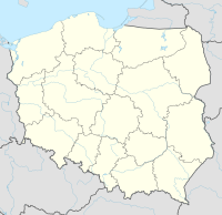
| Map | |||||||||||||||||||||||
| Runways | |||||||||||||||||||||||
| |||||||||||||||||||||||
Białystok-Krywlany Airport (ICAO: EPBK) is an airport in Białystok, Poland.
Białystok-Krywlany Airport history
The origins of the Białystok-Krywlany Airport began in 1910, when Earl Michael Scipio del Campo piloted the first plane over Bialystok in 1910, saying, 'I flew over the city the German Zeppelins'.[citation needed] By the summer of 1915, the Z12 had dropped around 9 tons of bombs on the trunk railway line between Warsaw and Petrograd, as well as the stations at Malkina and Bialystok; one flight carried a load of 3 tons. At the time, the airport was limited to a primitive airstrip. The selection of the area for a new airport occurred on February 19, 1930, on the premises of the Provincial Committee L0PP on Warsaw Street. A representative of the Department of Aerospace, Engineer Hennenberg, presented four alternatives for the location of the airport, calling it a professional "field of ups", indicating the area is situated between the property Dojlidy and forest west of the farm Krywlany. After three years of negotiations, a decision was made. In 1935, the first hangar facilities and buildings were built. Miroslaw Mikiciuk and Jan Tadeusz Puśko (Opposite the storms and clouds), served as a backup landing base for the fifth Aviation Regiment in Lida. Shortly before the outbreak of World War II, lighting was installed for night flights and construction started on a concrete runway. During World War II, the airport benefited from its use by the German Air Force.
Post-war activity 1945-onwards
Shortly after the war, the Bialystok Branch of the LOT Polish Airlines was created. On 30 April 1945, airlines began flying routes every week on Mondays, Wednesdays, and Fridays using Douglas DC-3 aircraft. The flight from Bialystok to Warsaw lasted 50 minutes and tickets cost $400. This service was quickly discontinued. Since that time the airport has not seen regular service, with only gliders utilizing the airport. During the mid-'80s border guards stationed helicopters and light aircraft at the airport, in addition to a helicopter ambulance.
Passenger airport extension
Currently, Białystok is the largest EU city without an operating passenger airport. New plans have been announced to extend and modernize the airport, including the addition of a new runway to offer a passenger airline service. These led to a referendum in 2017.
Passenger Airport Referendum
A referendum was held January 15th, 2017, with 98% of the voters showing support for a new regional airport. Turnout was just 12.96%, not enough for the results to be considered binding. The majority of voters were inhabitants of Białystok.[1]
Airlines and destinations
| Airlines | Destinations |
|---|---|
| None | None |
| Airport | City | IATA | ICAO | Purpose | El.(m) | Direct. | Surface | Runway (m) | Coordinates |
|---|---|---|---|---|---|---|---|---|---|
| Białystok-Krywlany
(only grass used) |
Białystok | QYY | EPBK | Sport, Border guard, EMT | 153 | 14/32 | Concrete | 08/26 950 x 200, 01/19 880 x 200, 14R/32L 830 x 100, 14L/32R 830 x 40 - all grass
(1420 x 50 concrete not used) |
53°06′05″N 23°10′14″E / 53.10139°N 23.17056°E |
| Białystok-Krywlany
(has also unusable paved rwy) |
Białystok | QYY | EPBK | Sport | 153 | 08/26 | Grass | 950 x 200 | 53°06′14″N 23°10′41″E / 53.10389°N 23.17806°E |
References
- ^ "Wynik referendum Oficial NIE nieważny. Frekwencja nie przekroczyła 13%". BiałystokOnline.pl (in Polish). Retrieved 13 May 2017.
Bibliography
- Lehmann, Ernst A.; Mingos, Howard. 1927. [The Zeppelins. The Development of the Airship, with the Story of the Zepplins Air Raids in the World War.] Error: {{Lang}}: text has italic markup (help) Published by I. H. SEARS & COMPANY, Inc. New York International Clearinghouse for Hydrogen Based Commerce - Zepplins (online chapters I to VII)
