

Cape Arkona: Difference between revisions
Miracle Pen (talk | contribs) rm superfluous dab per WP:D#Usage guidelines |
|||
| (47 intermediate revisions by 35 users not shown) | |||
| Line 1: | Line 1: | ||
{{Short description|Cape on the island of Rügen in Mecklenburg-Vorpommern, Germany}} |
|||
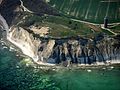
[[Image:Kap Arkona2.jpg|thumb|250px|View of Cape Arkona]] |
[[Image:Kap Arkona2.jpg|thumb|250px|View of Cape Arkona]] |
||
[[File:Putgarten, Kap Arkona (2011-05-21) 3.JPG|thumb|250px|Slavic cult site [[Jaromarsburg]] at [[Cape Arkona]], island of [[Rügen]].]] |
|||
'''Cape Arkona''' ({{ |
'''Cape Arkona''' ({{Langx|de|Kap Arkona}}) is a 45-metre (150-foot) high [[Cape (geography)|cape]] on the island of [[Rügen]] in [[Mecklenburg-Vorpommern]], [[Germany]]. It forms the tip of the [[Wittow]] peninsula, just a few kilometres north of the [[Jasmund National Park]]. The [[protected landscape]] of Cape Arkona, together with the fishing village of [[Vitt]], belongs to the municipality of [[Putgarten]] and is one of the most popular tourist destinations on Rügen, receiving about 800,000 visitors annually. |
||
On the cape there are two [[lighthouses]], a navigation tower, two military bunker complexes, the [[Slavic peoples|Slavic]] temple fortress of ''[[Jaromarsburg]]'' and several tourist buildings (restaurants, pubs and souvenir shops). |
On the cape there are two [[lighthouses]], a navigation tower, two military bunker complexes, the [[Slavic peoples|Slavic]] temple fortress of ''[[Jaromarsburg]]'' and several tourist buildings (restaurants, pubs and souvenir shops). |
||
Because of its geology and the weathering that occurs here, there are frequent coastal collapses especially in winter. |
Because of its geology and the weathering that occurs here, there are frequent coastal collapses, especially in winter. |
||
Cape Arkona is often referred to as "the northernmost point of Rügen", which is not true. Approximately one kilometre to the north-west, there is a point on the [[steep coast]], known as the ''Gellort'', which is a little further north. Directly at the foot of the Gellort is a 165-ton [[glacial erratic]] boulder known as the ''[[Siebenschneiderstein]]'' ([[Low German]]: ''Söbenschniedersteen''). The cape offers |
Cape Arkona is often referred to as "the northernmost point of Rügen", which is not true. Approximately one kilometre to the north-west, there is a point on the [[steep coast]], known as the ''Gellort'', which is a little further north. Directly at the foot of the Gellort is a 165-ton [[glacial erratic]] boulder known as the ''[[Siebenschneiderstein]]'' ([[Low German]]: ''Söbenschniedersteen''). The cape offers a view of the island, both from land or sea. |
||
== Lighthouses and navigation tower == |
== Lighthouses and navigation tower == |
||
{{main|Cape Arkona Lighthouse}} |
{{main|Cape Arkona Lighthouse}} |
||
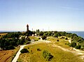
[[File:LeuchttürmeArkona.jpg|thumb|left|upright|Lighthouses]] |
|||
The smaller of the two lighthouses was built of brick in 1826/27 based on plans by [[Karl Friedrich Schinkel]] and taken into service in 1828. It is 19.3 metres high and has a focal height of {{Höhe|60|DE-NN|link=true}}. The rooms of the three-storey tower are used as operating and storage rooms. It is also called the ''Schinkelturm'' ("Schinkel Tower"). On 31 March 1905 it was taken out of service. It is the second oldest lighthouse on the German [[Baltic Sea]] coast after the [[Travemünde Lighthouse]]. |
The smaller of the two lighthouses was built of brick in 1826/27 based on plans by [[Karl Friedrich Schinkel]] and taken into service in 1828. It is 19.3 metres high and has a focal height of {{Höhe|60|DE-NN|link=true}}. The rooms of the three-storey tower are used as operating and storage rooms. It is also called the ''Schinkelturm'' ("Schinkel Tower"). On 31 March 1905 it was taken out of service. It is the second oldest lighthouse on the German [[Baltic Sea]] coast after the [[Travemünde Lighthouse]]. |
||
| Line 18: | Line 17: | ||
The largest tower was built in 1901/02 right next to the old tower and entered service on 1 April 1905. It is 35 metres high and has a focal height of {{Höhe|75|DE-NN}}. It is made of brick and stands on an octagonal granite base. For 90 years its light source was two [[arc lamp]]s, but they were replaced in 1995 by a [[Metal-halide lamp]]. This, combined with the rotating triple optics, emits 3 flashes every 17 seconds. |
The largest tower was built in 1901/02 right next to the old tower and entered service on 1 April 1905. It is 35 metres high and has a focal height of {{Höhe|75|DE-NN}}. It is made of brick and stands on an octagonal granite base. For 90 years its light source was two [[arc lamp]]s, but they were replaced in 1995 by a [[Metal-halide lamp]]. This, combined with the rotating triple optics, emits 3 flashes every 17 seconds. |
||
The old naval navigation tower (German: ''Peilturm'') was built in 1927 of brick and acted as |
The old naval navigation tower (German: ''Peilturm'') was built in 1927 of brick and acted as a [[electric beacon|marine navigation beacon]]. From 1911 to 1925, attempts were made - which were ground-breaking for that time - to improve navigation for the [[Kings Line|Sassnitz-Trelleborg]] railway ferry, established in 1909, using the emission of radio waves. The foundations of the associated radio operating facility inside the ramparts have survived to this day. The technical facilities of the navigation tower were destroyed, however, in 1945 |
||
All three towers were renovated in the early 1990s and are open to visitors. In the old lighthouse, there is now a museum and a branch of the registry office. Marriages may be commemorated here on a small plaque in the ground in front of the tower. The navigation tower is used as an art museum and studio. On each tower there is a viewing platform from which there are unobstructed views of Rügen and especially the peninsula of Wittow. In clear weather you can even see as far as the [[Denmark|Danish]] island of [[Møn]]. |
All three towers were renovated in the early 1990s and are open to visitors. In the old lighthouse, there is now a museum and a branch of the registry office. Marriages may be commemorated here on a small plaque in the ground in front of the tower. The navigation tower is used as an art museum and studio. On each tower there is a viewing platform from which there are unobstructed views of Rügen and especially the peninsula of Wittow. In clear weather you can even see as far as the [[Denmark|Danish]] island of [[Møn]]. |
||
| Line 25: | Line 24: | ||
== Jaromarsburg == |
== Jaromarsburg == |
||
{{main|Jaromarsburg}} |
{{main|Jaromarsburg|Siege of Arkona}} |
||
[[File:Kap Arkona - Peilturm und Burgwall.jpg|thumb|left|The navigation tower with the [[Slavic burgwall|Slavic fortification]] of the Jaromarsburg behind it]] |
|||
[[Image:Bishop Absalon topples the god Svantevit at Arkona.PNG|thumb|right|Bishop Absalon topples the god [[Svantevit]] at Arkona in 1169]] |
[[Image:Bishop Absalon topples the god Svantevit at Arkona.PNG|thumb|right|Bishop Absalon topples the god [[Svantevit]] at Arkona in 1169]] |
||
From the |
From the 9th<ref>Torsten Kempke: Skandinavisch-slawische Kontakte an der südlichen Ostseeküste im 7. bis 9. Jahrhundert, in Ole Harck, Christian Lübke (Hrsgg.): Zwischen Reric und Bornhöved. Die Beziehungen zwischen den Dänen und ihren slawischen Nachbarn vom 9. bis ins 13. Jahrhundert (Forschungen zur Geschichte und Kultur des Östlichen Mitteleuropa, vol. 11), Stuttgart 2000, pp. 9-22, esp. p. 14; Heike Reimann, Fred Ruchhöft, Cornelia Willich: Rügen im Mittelalter. Eine interdisziplinäre Studie zur mittelalterlichen Besiedlung auf Rügen (Forschungen zur Geschichte und Kultur des Östlichen Mitteleuropa, vol. 36), Stuttgart 2011, pp. 42 ff.</ref> to the 12th centuries, the Jaromarsburg was a [[cult (religious practice)|cult]] site for the [[Rani (Slavic tribe)|Rani]], a Slavic tribe, which was dedicated to their god [[Svantevit]]. Located at the tip of the cape, it was protected on three sides by cliffs and from the land side by a 25-metre-high [[Gord (archaeology)|burgwall]]. The [[temple]] located within the ramparts grew in importance as a religious centre for the Slavs of [[Mecklenburg]] after the destruction of [[Rethra]] in 1068. In 1168, the Danish king [[Valdemar I of Denmark|Valdemar I]] conquered Rügen which then became [[Christianity|Christian]]. Churches were established and the castle and its temple destroyed. |
||
At the tip of Arkona in recent centuries, the cliffs have repeatedly collapsed into the sea, with the result that only the ramparts of the Jaromarsburg are still visible today. |
At the tip of Arkona in recent centuries, the cliffs have repeatedly collapsed into the sea, with the result that only the ramparts of the Jaromarsburg are still visible today. |
||
| Line 37: | Line 35: | ||
== Steps to the beach: ''Königstreppe'' and ''Veilchentreppe'' == |
== Steps to the beach: ''Königstreppe'' and ''Veilchentreppe'' == |
||
[[File:Königstreppe.jpg|thumb|left|upright|The ''Königstreppe'' steps]] |
|||
[[File:Veilchentreppe.jpg|thumb|upright|The ''Veilchentreppe'' steps]] |
[[File:Veilchentreppe.jpg|thumb|upright|The ''Veilchentreppe'' steps]] |
||
Several metres west of Cape Arkona is the ''Königstreppe'' ("King's Staircase"), whose 230 steps climb up the 42-metre-high cliff 230. |
Several metres west of Cape Arkona is the ''Königstreppe'' ("King's Staircase"), whose 230 steps climb up the 42-metre-high cliff 230. |
||
The [[Sweden|Swedish]] king, [[Frederick of Sweden|Frederick I]] – Rügen then belonged to Sweden – had a [[daymark]] erected near the present-day steps during the [[Russo-Swedish War (1741–1743)]] in order to warn the population. Hence the spot was known as the ''Königssteig'' or "King's Climb". |
The [[Sweden|Swedish]] king, [[Frederick of Sweden|Frederick I]] – Rügen then belonged to Sweden – had a [[daymark]] erected near the present-day steps during the [[Russo-Swedish War (1741–1743)]] in order to warn the population. Hence the spot was known as the ''Königssteig'' or "King's Climb". |
||
In 1833, for the arrival of the steamboat ''Hercules'' during its Imperial Russian [[chronometer]] expedition, the [[Prussia]]n king, [[Frederick William III of Prussia|Frederick William III]] - Rügen was now Prussian - had a landing stage and flight of steps built.<ref>[http://articles.adsabs.harvard.edu/full/1846AN.....24...87. Die Kaiserlich-russische Chronometer-Expedition in der Ostsee zwischen Pulkowa, Moskau und Warschau im Jahre 1833]</ref> From this point in 1865, the first [[telegraphy|telegraph cable]] was laid under the Baltic Sea to Sweden. With the rise of the island's coastal resorts, tourism at Cape Arkona grew. Many travelers came by excursion boats that moored at the pier at the foot of the steps. The landing stage was, however, completely destroyed by the [[storm flood]] of 1953. The new ''Königstreppe'' steps were completed in 1995 at the same historic spot, taking a year to build. |
In 1833, for the arrival of the steamboat ''Hercules'' during its Imperial Russian [[Marine chronometer|chronometer]] expedition, the [[Prussia]]n king, [[Frederick William III of Prussia|Frederick William III]] - Rügen was now Prussian - had a landing stage and flight of steps built.<ref>[http://articles.adsabs.harvard.edu/full/1846AN.....24...87. Die Kaiserlich-russische Chronometer-Expedition in der Ostsee zwischen Pulkowa, Moskau und Warschau im Jahre 1833]</ref> From this point in 1865, the first [[telegraphy|telegraph cable]] was laid under the Baltic Sea to Sweden. With the rise of the island's coastal resorts, tourism at Cape Arkona grew. Many travelers came by excursion boats that moored at the pier at the foot of the steps. The landing stage was, however, completely destroyed by the [[storm flood]] of 1953. The new ''Königstreppe'' steps were completed in 1995 at the same historic spot, taking a year to build. |
||
South of the remnants of the ramparts at Jaromarsburg are the ''Veilchentreppe'' ("Violet Staircase"), a descent to the beach that runs from Arkona to Vitt. The name comes from the violets that grow around the staircase in spring. |
South of the remnants of the ramparts at Jaromarsburg are the ''Veilchentreppe'' ("Violet Staircase"), a descent to the beach that runs from Arkona to Vitt. The name comes from the violets that grow around the staircase in spring. |
||
| Line 50: | Line 46: | ||
== Bunkers == |
== Bunkers == |
||
[[File:Kap Arkona - Leuchtturm-Aussicht - Arkona-Bunker 2.jpg|thumb|View of the Wehrmacht bunker of ''Schinkelturm'']] |
[[File:Kap Arkona - Leuchtturm-Aussicht - Arkona-Bunker 2.jpg|thumb|View of the Wehrmacht bunker of ''Schinkelturm'']] |
||
There are |
There are two [[bunker]]s in the immediate neighbourhood of the two lighthouses. The smaller, older bunker dates from ''[[Wehrmacht]]'' times and, in GDR days, housed an outpost of the [[Border Troops of the German Democratic Republic|6th (Coastal) Border Brigade]]. It is generally called the ''Arkona Bunker''. |
||
[[File:Kap Arkona - |
[[File:Kap Arkona - Leuchtturm-Aussicht - NVA-Bunker 1.jpg|thumb|View of the [[National People's Army|NVA]] bunker from the new lighthouse]] |
||
[[File:Kap Arkona - Leuchtturm-Aussicht - NVA-Bunker 1.jpg|thumb|View from the new lighthouse on the [[National People's Army|NVA]] bunker]] |
|||
The larger, newer bunker was built from 1979 to 1986 and acted as a command post for the [[Sixth Flotilla (Volksmarine)|Sixth Flotilla]], stationed on [[Bug (Rügen)|Bug]], and the [[Baltic Fleet]] (VOF). Starting from a main central tunnel with two entrances, there are several [[autonomous]] individual bunkers with a total area of 2,000 square metres. They comprise three large bunkers (type FB-75) and nine small ones (type FB-3), made of prefabricated concrete elements (FB = prefabricated bunker). The FB-75 type bunker had an intermediate floor level, where the sleeping areas were located, and an emergency exit. Each individual shelter has a main corridor and two [[airlock]]s. Over the top is a 3 |
The larger, newer bunker was built from 1979 to 1986 and acted as a command post for the [[Sixth Flotilla (Volksmarine)|Sixth Flotilla]], stationed on [[Bug (Rügen)|Bug]], and the [[Baltic Fleet]] (VOF). Starting from a main central tunnel with two entrances, there are several [[autonomous]] individual bunkers with a total area of 2,000 square metres. They comprise three large bunkers (type FB-75) and nine small ones (type FB-3), made of prefabricated concrete elements (FB = prefabricated bunker). The FB-75 type bunker had an intermediate floor level, where the sleeping areas were located, and an emergency exit. Each individual shelter has a main corridor and two [[airlock]]s. Over the top is a {{convert|3|to|5|m|ft|adj=mid|-high}} earth covering, from which protrude dozens of ventilation tubes. |
||
In 1985, on the 30th anniversary of the [[National People's Army|National People's Army (NVA)]], an aerial photograph of Cape Arkona, with the bunker complex in the background, was publicised in the picture book ''Soldaten des Volkes'' ("Soldiers of the People"). The bunkers were uncamouflaged. How the photograph was allowed to appear in this book is not clear, but it was withdrawn from circulation again just three days after its publication. A later edition of the illustrated book was published with the aerial image omitted. Today, the original picture book is a collector's piece. |
In 1985, on the 30th anniversary of the [[National People's Army|National People's Army (NVA)]], an aerial photograph of Cape Arkona, with the bunker complex in the background, was publicised in the picture book ''Soldaten des Volkes'' ("Soldiers of the People"). The bunkers were uncamouflaged. How the photograph was allowed to appear in this book is not clear, but it was withdrawn from circulation again just three days after its publication. A later edition of the illustrated book was published with the aerial image omitted. Today, the original picture book is a collector's piece. |
||
From 1986, |
From 1986, 50–70 soldiers of the ''[[Volksmarine]]'' ("People's Navy") were on duty here for two to three days, three to four times a year, as part of naval exercises. The standard complement was four men. On 3 October 1990, the day of [[German reunification]], the site was closed. |
||
The bunkers were purchased and successively renovated by the municipality of Putgarten. The Arkona Bunker now houses an art gallery and the NVA Bunker an exhibition of GDR fittings and equipment as well as a series of photographs on the ''Volksmarine''. |
The bunkers were purchased and successively renovated by the municipality of Putgarten. The Arkona Bunker now houses an art gallery and the NVA Bunker an exhibition of GDR fittings and equipment as well as a series of photographs on the ''Volksmarine''. |
||
== Access == |
== Access == |
||
[[File:Schiff Cap Arkona.jpg|thumb|left|Ship at Cape Arkona]] |
|||
[[File:Putgarten Touristenstation.JPG|thumb|The Arkona road train in Putgarten]] |
[[File:Putgarten Touristenstation.JPG|thumb|The Arkona road train in Putgarten]] |
||
Just outside Putgarten is a large car park where all visitors to the cape have to park their cars or tour buses. From there the cape may be accessed on foot (1.8 km), by horse and carriage or on the Cape Arkona [[trackless train|road train]] (''Kap-Arkona-Bahn''). The various sights may also be visited by bicycle. |
Just outside Putgarten is a large car park where all visitors to the cape have to park their cars or tour buses. From there the cape may be accessed on foot (1.8 km), by horse and carriage or on the Cape Arkona [[trackless train|road train]] (''Kap-Arkona-Bahn''). The various sights may also be visited by bicycle. |
||
Since 1993 the Cape Arkona Train has provided services from Putgarten to Cape Arkona and the fishing village of Vitt. It does not run on rails as the name suggests, but is a [[Trackless train|road train]] that runs on wheels on normal roads. The train is hauled by a tractor designed to look like a [[steam locomotive]] but since 1996 has actually been powered by |
Since 1993 the Cape Arkona Train has provided services from Putgarten to Cape Arkona and the fishing village of Vitt. It does not run on rails as the name suggests, but is a [[Trackless train|road train]] that runs on wheels on normal roads. The train is hauled by a tractor designed to look like a [[steam locomotive]] but since 1996 has actually been powered by a more environmentally-friendly [[gas engine]]. |
||
Ships operated by the ''Reederei Ostsee-Tour'' also run daily from [[Binz]] and [[Sassnitz]] to Cape Arkona. |
Ships operated by the ''Reederei Ostsee-Tour'' also run daily from [[Binz]] and [[Sassnitz]] to Cape Arkona. |
||
| Line 76: | Line 69: | ||
== Climate == |
== Climate == |
||
[[File:Klimadiagramm-deutsch-Kap Arkona (MV)-Deutschland.png|thumb|Climatic diagram]] |
[[File:Klimadiagramm-deutsch-Kap Arkona (MV)-Deutschland.png|thumb|Climatic diagram]] |
||
The climate at Cape Arkona is typical of the North |
The climate at Cape Arkona is typical of the North Vorpommern coast. The average annual temperature is 7.9 °C. Precipitation amounts to 521 mm per year. Because of its proximity to the sea, its humidity is very high. |
||
{{Weather box|width=auto |
|||
== Accident == |
|||
|location = Cape Arkona (1991−2020 normals, extremes 1951–2000) |
|||
|metric first = yes |
|||
|single line = yes |
|||
|Jan record high C = 11.1 |
|||
|Feb record high C = 15.6 |
|||
|Mar record high C = 18.4 |
|||
|Apr record high C = 24.6 |
|||
|May record high C = 26.4 |
|||
|Jun record high C = 30.6 |
|||
|Jul record high C = 30.2 |
|||
|Aug record high C = 31.3 |
|||
|Sep record high C = 25.9 |
|||
|Oct record high C = 25.0 |
|||
|Nov record high C = 17.8 |
|||
|Dec record high C = 13.1 |
|||
|year record high C = 31.3 |
|||
|Jan record low C = -17.0 |
|||
|Feb record low C = -18.9 |
|||
|Mar record low C = -12.8 |
|||
|Apr record low C = -2.8 |
|||
|May record low C = -0.7 |
|||
|Jun record low C = 3.2 |
|||
|Jul record low C = 7.8 |
|||
|Aug record low C = 7.8 |
|||
|Sep record low C = 3.4 |
|||
|Oct record low C = -1.3 |
|||
|Nov record low C = -8.7 |
|||
|Dec record low C = -13.7 |
|||
|year record low C = -18.9 |
|||
|Jan high C = 3.2 |
|||
|Feb high C = 3.3 |
|||
|Mar high C = 5.6 |
|||
|Apr high C = 9.5 |
|||
|May high C = 13.7 |
|||
|Jun high C = 17.7 |
|||
|Jul high C = 20.4 |
|||
|Aug high C = 20.7 |
|||
|Sep high C = 17.1 |
|||
|Oct high C = 12.3 |
|||
|Nov high C = 7.6 |
|||
|Dec high C = 4.5 |
|||
| year high C = 11.3 |
|||
|Jan mean C = 1.5 |
|||
|Feb mean C = 1.6 |
|||
|Mar mean C = 3.3 |
|||
|Apr mean C = 6.6 |
|||
|May mean C = 10.8 |
|||
|Jun mean C = 14.6 |
|||
|Jul mean C = 17.4 |
|||
|Aug mean C = 17.8 |
|||
|Sep mean C = 14.7 |
|||
|Oct mean C = 10.2 |
|||
|Nov mean C = 5.9 |
|||
|Dec mean C = 2.8 |
|||
|year mean C = 8.9 |
|||
|Jan low C = -0.3 |
|||
|Feb low C = -0.2 |
|||
|Mar low C = 1.2 |
|||
|Apr low C = 4.3 |
|||
|May low C = 8.2 |
|||
|Jun low C = 12.0 |
|||
|Jul low C = 14.8 |
|||
|Aug low C = 15.2 |
|||
|Sep low C = 12.4 |
|||
|Oct low C = 8.2 |
|||
|Nov low C = 4.1 |
|||
|Dec low C = 1.0 |
|||
| year low C =6.7 |
|||
| precipitation colour = green |
|||
|Jan precipitation mm = 39.9 |
|||
|Feb precipitation mm = 29.2 |
|||
|Mar precipitation mm = 30.4 |
|||
|Apr precipitation mm = 28.3 |
|||
|May precipitation mm = 41.5 |
|||
|Jun precipitation mm = 56.9 |
|||
|Jul precipitation mm = 56.6 |
|||
|Aug precipitation mm = 67.8 |
|||
|Sep precipitation mm = 52.9 |
|||
|Oct precipitation mm = 53.8 |
|||
|Nov precipitation mm = 45.6 |
|||
|Dec precipitation mm = 44.9 |
|||
| year precipitation mm =547.8 |
|||
| unit precipitation days = 0.1 mm |
|||
|Jan precipitation days = 16.3 |
|||
|Feb precipitation days = 14.7 |
|||
|Mar precipitation days = 12.9 |
|||
|Apr precipitation days = 10.3 |
|||
|May precipitation days = 11.2 |
|||
|Jun precipitation days = 12.2 |
|||
|Jul precipitation days = 12.3 |
|||
|Aug precipitation days = 13.5 |
|||
|Sep precipitation days = 13.2 |
|||
|Oct precipitation days = 15.7 |
|||
|Nov precipitation days = 16.2 |
|||
|Dec precipitation days = 17.8 |
|||
|year precipitation days = 166.4 |
|||
|Jan sun = 48.4 |
|||
|Feb sun = 69.0 |
|||
|Mar sun = 143.6 |
|||
|Apr sun = 225.8 |
|||
|May sun = 277.3 |
|||
|Jun sun = 274.5 |
|||
|Jul sun = 277.3 |
|||
|Aug sun = 247.4 |
|||
|Sep sun = 179.0 |
|||
|Oct sun = 115.3 |
|||
|Nov sun = 52.8 |
|||
|Dec sun = 37.3 |
|||
|year sun = 1948.4 |
|||
|Jan humidity = 87.4 |
|||
|Feb humidity = 86.1 |
|||
|Mar humidity = 83.9 |
|||
|Apr humidity = 81.2 |
|||
|May humidity = 80.5 |
|||
|Jun humidity = 80.0 |
|||
|Jul humidity = 79.8 |
|||
|Aug humidity = 79.7 |
|||
|Sep humidity = 80.3 |
|||
|Oct humidity = 82.8 |
|||
|Nov humidity = 86.7 |
|||
|Dec humidity = 88.0 |
|||
| year humidity =83.0 |
|||
|unit snow days = 1.0 cm |
|||
|Jan snow days = 6.4 |
|||
|Feb snow days = 7.6 |
|||
|Mar snow days = 3.9 |
|||
|Apr snow days = 0.2 |
|||
|May snow days = 0 |
|||
|Jun snow days = 0 |
|||
|Jul snow days = 0 |
|||
|Aug snow days = 0 |
|||
|Sep snow days = 0 |
|||
|Oct snow days = 0 |
|||
|Nov snow days = 0.6 |
|||
|Dec snow days = 3.6 |
|||
|year snow days = 22.9 |
|||
| source 1 = [[NOAA]]<ref name=NOAA>{{cite web |
|||
| archive-url = https://web.archive.org/web/20230914161643/https://www.nodc.noaa.gov/archive/arc0216/0253808/1.1/data/0-data/Region-6-WMO-Normals-9120/Germany/CSV/Arkona_10091.csv |
|||
| archive-date = 14 September 2023 |
|||
| url = https://www.nodc.noaa.gov/archive/arc0216/0253808/1.1/data/0-data/Region-6-WMO-Normals-9120/Germany/CSV/Arkona_10091.csv |
|||
| title = Arkona Climate Normals 1991–2020 |
|||
| publisher = [[National Oceanic and Atmospheric Administration]] |
|||
| access-date = 15 September 2023}}</ref> |
|||
|source 2 = [[Deutscher Wetterdienst]]<ref name = DWD> |
|||
{{cite web |
|||
| url = https://www.dwd.de/DWD/klima/beratung/ak/ak_100910_kt.pdf |
|||
| title = Klimatafel von Arkona / Rügen, Mecklenburg-Vorpommern / Deutschland |
|||
| work = Baseline climate means (1961–1990) from stations all over the world |
|||
| publisher = Deutscher Wetterdienst |
|||
| language = de |
|||
| access-date = 9 November 2018}}</ref> |
|||
}} |
|||
== Accident == |
|||
On Boxing Day in 2011, there was a major rock slide at Cape Arkona, which buried a ten year old girl and seriously injured her mother. A weeklong search for the child was given up on 8 January 2012 and it was not until 31 January 2012 that the child's body was found at the foot of the cliff. |
|||
On 26 December 2011, there was a major rock slide at Cape Arkona, which buried a ten-year-old girl and seriously injured her mother. A weeklong search for the child was given up on 8 January 2012 and it was not until 31 January 2012 that the child's body was found at the foot of the cliff. |
|||
== |
== Maritime == |
||
;Ships |
|||
[[File:Schiff Cap Arkona.jpg|thumb|right|Ship named ''Cap Arkona'']] |
|||
The following ships have been named after Cape Arkona: |
The following ships have been named after Cape Arkona: |
||
| Line 88: | Line 236: | ||
*The cargo ship, ''[[Cape Arkona (ship)|Kap Arkona]]'', owned by ''Deutsche Seereederei'' (DSR). |
*The cargo ship, ''[[Cape Arkona (ship)|Kap Arkona]]'', owned by ''Deutsche Seereederei'' (DSR). |
||
*The rescue cruiser, ''[[Arkona (1992)|Arkona]]'', of the [[German Maritime Search and Rescue Service]]. |
*The rescue cruiser, ''[[Arkona (1992)|Arkona]]'', of the [[German Maritime Search and Rescue Service]]. |
||
;Other |
|||
An [[offshore wind farm]] called Arkona<ref>[http://www.tu.no/artikler/statoils-gjor-sin-storste-fornybar-investering-noensinne/346695 Statoil gjør sin største fornybar-investering noensinne]</ref> is in development 35 km north-east of the point, designed with 60 [[Siemens Wind Power]] 6 MW gearless turbines.<ref>{{cite web|url=http://cleantechnica.com/2016/04/26/siemens-awarded-385-mw-offshore-wind-order-arkona-wind-farm/ |title=Siemens Awarded 385 MW Offshore Wind Order For Arkona Wind Farm|work=[[CleanTechnica]]|access-date=27 April 2016}}</ref> |
|||
{{clear}} |
|||
== Gallery == |
== Gallery == |
||
| Line 107: | Line 259: | ||
== Literature == |
== Literature == |
||
* Stefan Best: ''Geheime Bunkeranlagen der DDR'', Motorbuchverlag, Stuttgart, ISBN |
* Stefan Best: ''Geheime Bunkeranlagen der DDR'', Motorbuchverlag, Stuttgart, {{ISBN|3-613-02332-6}} |
||
* Peter Feist: ''Der Burgwall am Kap Arkona'', Kai Homilius Verlag, Berlin, 1995, ISBN |
* Peter Feist: ''Der Burgwall am Kap Arkona'', Kai Homilius Verlag, Berlin, 1995, {{ISBN|3-931121-00-3}} |
||
== External links == |
== External links == |
||
{{Commons category|Cape Arkona}} |
{{Commons category|Cape Arkona}} |
||
* {{wikivoyage-inline|Cape Arkona}} |
|||
* [http://www.kap-arkona.de/ kap-arkona.de] Cape Arkona page of the municipality of Putgarten |
* [http://www.kap-arkona.de/ kap-arkona.de] Cape Arkona page of the municipality of Putgarten |
||
* {{LBMV SWW|kap+arkona}} |
* {{LBMV SWW|kap+arkona}} |
||
* [http://www.wizlaw.de/html/1__gardvogteien.html Die Gardvogteien Wîtov/Wittow und Jâsmund/Jasmund] Website with information about Arkona |
* [http://www.wizlaw.de/html/1__gardvogteien.html Die Gardvogteien Wîtov/Wittow und Jâsmund/Jasmund] Website with information about Arkona |
||
* {{ |
* {{cite web|author=Holger Vonberg |url=http://www.ostsee-zeitung.de/archiv.phtml?Param=DB-Artikel&ID=1986024 |title=Unterirdisches Jubiläum am Kap |work=Ostsee-Zeitung |date=4 October 2005 |access-date=8 October 2006 |url-status=dead |archive-url=https://web.archive.org/web/20070927235628/http://www.ostsee-zeitung.de/archiv.phtml?Param=DB-Artikel&ID=1986024 |archive-date=27 September 2007 }} |
||
{{Baltic emporia}} |
{{Baltic emporia}} |
||
| Line 121: | Line 274: | ||
{{Coord|54|40|35|N|13|26|16|E|region:DE-MV_type:landmark|display=title}} |
{{Coord|54|40|35|N|13|26|16|E|region:DE-MV_type:landmark|display=title}} |
||
{{Authority control}} |
|||
[[Category:Headlands of Germany|Arkona]] |
[[Category:Headlands of Germany|Arkona]] |
||
[[Category:Geography of Rügen]] |
[[Category:Geography of Rügen]] |
||
[[Category:Putgarten]] |
[[Category:Putgarten]] |
||
[[Category:Landforms of Mecklenburg-Western Pomerania]] |
|||
{{Link GA|de}} |
|||
[[af:Kaap Arkona]] |
|||
[[bg:Аркона]] |
|||
[[cs:Arkona]] |
|||
[[de:Kap Arkona]] |
|||
[[es:Cabo Arkona]] |
|||
[[fr:Kap Arkona]] |
|||
[[ko:케이프 아르코나]] |
|||
[[id:Tanjung Arkona]] |
|||
[[it:Capo Arkona]] |
|||
[[lt:Arkonos kyšulys]] |
|||
[[mk:Аркона]] |
|||
[[nl:Kaap Arkona]] |
|||
[[nn:Kapp Arkona]] |
|||
[[pl:Arkona]] |
|||
[[ro:Capul Arkona]] |
|||
[[ru:Аркона (мыс)]] |
|||
[[sco:Cape Arkona]] |
|||
[[sk:Arkona (Nemecko)]] |
|||
[[szl:Arkona]] |
|||
[[sr:Рт Аркона]] |
|||
[[sv:Kap Arkona]] |
|||
[[uk:Мис Аркона]] |
|||
[[vi:Mũi Arkona]] |
|||
Latest revision as of 15:56, 21 October 2024

Cape Arkona (German: Kap Arkona) is a 45-metre (150-foot) high cape on the island of Rügen in Mecklenburg-Vorpommern, Germany. It forms the tip of the Wittow peninsula, just a few kilometres north of the Jasmund National Park. The protected landscape of Cape Arkona, together with the fishing village of Vitt, belongs to the municipality of Putgarten and is one of the most popular tourist destinations on Rügen, receiving about 800,000 visitors annually.
On the cape there are two lighthouses, a navigation tower, two military bunker complexes, the Slavic temple fortress of Jaromarsburg and several tourist buildings (restaurants, pubs and souvenir shops).
Because of its geology and the weathering that occurs here, there are frequent coastal collapses, especially in winter.
Cape Arkona is often referred to as "the northernmost point of Rügen", which is not true. Approximately one kilometre to the north-west, there is a point on the steep coast, known as the Gellort, which is a little further north. Directly at the foot of the Gellort is a 165-ton glacial erratic boulder known as the Siebenschneiderstein (Low German: Söbenschniedersteen). The cape offers a view of the island, both from land or sea.
Lighthouses and navigation tower
[edit]The smaller of the two lighthouses was built of brick in 1826/27 based on plans by Karl Friedrich Schinkel and taken into service in 1828. It is 19.3 metres high and has a focal height of 60 m above sea level (NN). The rooms of the three-storey tower are used as operating and storage rooms. It is also called the Schinkelturm ("Schinkel Tower"). On 31 March 1905 it was taken out of service. It is the second oldest lighthouse on the German Baltic Sea coast after the Travemünde Lighthouse.

The largest tower was built in 1901/02 right next to the old tower and entered service on 1 April 1905. It is 35 metres high and has a focal height of 75 m above NN. It is made of brick and stands on an octagonal granite base. For 90 years its light source was two arc lamps, but they were replaced in 1995 by a Metal-halide lamp. This, combined with the rotating triple optics, emits 3 flashes every 17 seconds.
The old naval navigation tower (German: Peilturm) was built in 1927 of brick and acted as a marine navigation beacon. From 1911 to 1925, attempts were made - which were ground-breaking for that time - to improve navigation for the Sassnitz-Trelleborg railway ferry, established in 1909, using the emission of radio waves. The foundations of the associated radio operating facility inside the ramparts have survived to this day. The technical facilities of the navigation tower were destroyed, however, in 1945
All three towers were renovated in the early 1990s and are open to visitors. In the old lighthouse, there is now a museum and a branch of the registry office. Marriages may be commemorated here on a small plaque in the ground in front of the tower. The navigation tower is used as an art museum and studio. On each tower there is a viewing platform from which there are unobstructed views of Rügen and especially the peninsula of Wittow. In clear weather you can even see as far as the Danish island of Møn.
Jaromarsburg
[edit]
From the 9th[1] to the 12th centuries, the Jaromarsburg was a cult site for the Rani, a Slavic tribe, which was dedicated to their god Svantevit. Located at the tip of the cape, it was protected on three sides by cliffs and from the land side by a 25-metre-high burgwall. The temple located within the ramparts grew in importance as a religious centre for the Slavs of Mecklenburg after the destruction of Rethra in 1068. In 1168, the Danish king Valdemar I conquered Rügen which then became Christian. Churches were established and the castle and its temple destroyed.
At the tip of Arkona in recent centuries, the cliffs have repeatedly collapsed into the sea, with the result that only the ramparts of the Jaromarsburg are still visible today.
Steps to the beach: Königstreppe and Veilchentreppe
[edit]
Several metres west of Cape Arkona is the Königstreppe ("King's Staircase"), whose 230 steps climb up the 42-metre-high cliff 230. The Swedish king, Frederick I – Rügen then belonged to Sweden – had a daymark erected near the present-day steps during the Russo-Swedish War (1741–1743) in order to warn the population. Hence the spot was known as the Königssteig or "King's Climb".
In 1833, for the arrival of the steamboat Hercules during its Imperial Russian chronometer expedition, the Prussian king, Frederick William III - Rügen was now Prussian - had a landing stage and flight of steps built.[2] From this point in 1865, the first telegraph cable was laid under the Baltic Sea to Sweden. With the rise of the island's coastal resorts, tourism at Cape Arkona grew. Many travelers came by excursion boats that moored at the pier at the foot of the steps. The landing stage was, however, completely destroyed by the storm flood of 1953. The new Königstreppe steps were completed in 1995 at the same historic spot, taking a year to build.
South of the remnants of the ramparts at Jaromarsburg are the Veilchentreppe ("Violet Staircase"), a descent to the beach that runs from Arkona to Vitt. The name comes from the violets that grow around the staircase in spring.
Bunkers
[edit]
There are two bunkers in the immediate neighbourhood of the two lighthouses. The smaller, older bunker dates from Wehrmacht times and, in GDR days, housed an outpost of the 6th (Coastal) Border Brigade. It is generally called the Arkona Bunker.

The larger, newer bunker was built from 1979 to 1986 and acted as a command post for the Sixth Flotilla, stationed on Bug, and the Baltic Fleet (VOF). Starting from a main central tunnel with two entrances, there are several autonomous individual bunkers with a total area of 2,000 square metres. They comprise three large bunkers (type FB-75) and nine small ones (type FB-3), made of prefabricated concrete elements (FB = prefabricated bunker). The FB-75 type bunker had an intermediate floor level, where the sleeping areas were located, and an emergency exit. Each individual shelter has a main corridor and two airlocks. Over the top is a 3-to-5-metre-high (9.8 to 16.4 ft) earth covering, from which protrude dozens of ventilation tubes.
In 1985, on the 30th anniversary of the National People's Army (NVA), an aerial photograph of Cape Arkona, with the bunker complex in the background, was publicised in the picture book Soldaten des Volkes ("Soldiers of the People"). The bunkers were uncamouflaged. How the photograph was allowed to appear in this book is not clear, but it was withdrawn from circulation again just three days after its publication. A later edition of the illustrated book was published with the aerial image omitted. Today, the original picture book is a collector's piece.
From 1986, 50–70 soldiers of the Volksmarine ("People's Navy") were on duty here for two to three days, three to four times a year, as part of naval exercises. The standard complement was four men. On 3 October 1990, the day of German reunification, the site was closed.
The bunkers were purchased and successively renovated by the municipality of Putgarten. The Arkona Bunker now houses an art gallery and the NVA Bunker an exhibition of GDR fittings and equipment as well as a series of photographs on the Volksmarine.
Access
[edit]
Just outside Putgarten is a large car park where all visitors to the cape have to park their cars or tour buses. From there the cape may be accessed on foot (1.8 km), by horse and carriage or on the Cape Arkona road train (Kap-Arkona-Bahn). The various sights may also be visited by bicycle.
Since 1993 the Cape Arkona Train has provided services from Putgarten to Cape Arkona and the fishing village of Vitt. It does not run on rails as the name suggests, but is a road train that runs on wheels on normal roads. The train is hauled by a tractor designed to look like a steam locomotive but since 1996 has actually been powered by a more environmentally-friendly gas engine.
Ships operated by the Reederei Ostsee-Tour also run daily from Binz and Sassnitz to Cape Arkona.
Climate
[edit]
The climate at Cape Arkona is typical of the North Vorpommern coast. The average annual temperature is 7.9 °C. Precipitation amounts to 521 mm per year. Because of its proximity to the sea, its humidity is very high.
| Climate data for Cape Arkona (1991−2020 normals, extremes 1951–2000) | |||||||||||||
|---|---|---|---|---|---|---|---|---|---|---|---|---|---|
| Month | Jan | Feb | Mar | Apr | May | Jun | Jul | Aug | Sep | Oct | Nov | Dec | Year |
| Record high °C (°F) | 11.1 (52.0) |
15.6 (60.1) |
18.4 (65.1) |
24.6 (76.3) |
26.4 (79.5) |
30.6 (87.1) |
30.2 (86.4) |
31.3 (88.3) |
25.9 (78.6) |
25.0 (77.0) |
17.8 (64.0) |
13.1 (55.6) |
31.3 (88.3) |
| Mean daily maximum °C (°F) | 3.2 (37.8) |
3.3 (37.9) |
5.6 (42.1) |
9.5 (49.1) |
13.7 (56.7) |
17.7 (63.9) |
20.4 (68.7) |
20.7 (69.3) |
17.1 (62.8) |
12.3 (54.1) |
7.6 (45.7) |
4.5 (40.1) |
11.3 (52.3) |
| Daily mean °C (°F) | 1.5 (34.7) |
1.6 (34.9) |
3.3 (37.9) |
6.6 (43.9) |
10.8 (51.4) |
14.6 (58.3) |
17.4 (63.3) |
17.8 (64.0) |
14.7 (58.5) |
10.2 (50.4) |
5.9 (42.6) |
2.8 (37.0) |
8.9 (48.0) |
| Mean daily minimum °C (°F) | −0.3 (31.5) |
−0.2 (31.6) |
1.2 (34.2) |
4.3 (39.7) |
8.2 (46.8) |
12.0 (53.6) |
14.8 (58.6) |
15.2 (59.4) |
12.4 (54.3) |
8.2 (46.8) |
4.1 (39.4) |
1.0 (33.8) |
6.7 (44.1) |
| Record low °C (°F) | −17.0 (1.4) |
−18.9 (−2.0) |
−12.8 (9.0) |
−2.8 (27.0) |
−0.7 (30.7) |
3.2 (37.8) |
7.8 (46.0) |
7.8 (46.0) |
3.4 (38.1) |
−1.3 (29.7) |
−8.7 (16.3) |
−13.7 (7.3) |
−18.9 (−2.0) |
| Average precipitation mm (inches) | 39.9 (1.57) |
29.2 (1.15) |
30.4 (1.20) |
28.3 (1.11) |
41.5 (1.63) |
56.9 (2.24) |
56.6 (2.23) |
67.8 (2.67) |
52.9 (2.08) |
53.8 (2.12) |
45.6 (1.80) |
44.9 (1.77) |
547.8 (21.57) |
| Average precipitation days (≥ 0.1 mm) | 16.3 | 14.7 | 12.9 | 10.3 | 11.2 | 12.2 | 12.3 | 13.5 | 13.2 | 15.7 | 16.2 | 17.8 | 166.4 |
| Average snowy days (≥ 1.0 cm) | 6.4 | 7.6 | 3.9 | 0.2 | 0 | 0 | 0 | 0 | 0 | 0 | 0.6 | 3.6 | 22.9 |
| Average relative humidity (%) | 87.4 | 86.1 | 83.9 | 81.2 | 80.5 | 80.0 | 79.8 | 79.7 | 80.3 | 82.8 | 86.7 | 88.0 | 83.0 |
| Mean monthly sunshine hours | 48.4 | 69.0 | 143.6 | 225.8 | 277.3 | 274.5 | 277.3 | 247.4 | 179.0 | 115.3 | 52.8 | 37.3 | 1,948.4 |
| Source 1: NOAA[3] | |||||||||||||
| Source 2: Deutscher Wetterdienst[4] | |||||||||||||
Accident
[edit]On 26 December 2011, there was a major rock slide at Cape Arkona, which buried a ten-year-old girl and seriously injured her mother. A weeklong search for the child was given up on 8 January 2012 and it was not until 31 January 2012 that the child's body was found at the foot of the cliff.
Maritime
[edit]- Ships

The following ships have been named after Cape Arkona:
- The German luxury ocean liner, SS Cap Arcona, launched in 1927.
- The cargo ship, Kap Arkona, owned by Deutsche Seereederei (DSR).
- The rescue cruiser, Arkona, of the German Maritime Search and Rescue Service.
- Other
An offshore wind farm called Arkona[5] is in development 35 km north-east of the point, designed with 60 Siemens Wind Power 6 MW gearless turbines.[6]
Gallery
[edit]-
 Cape Arkona from the air
 -
 View from the navigation tower


See also
[edit]- Pomerania during the Early Middle Ages
- Pomerania during the Late Middle Ages
- Conversion of Pomerania
- Rugii (Germanic Tribe)
- Rani (Slavic tribe)
- Principality of Rügen
References
[edit]- ^ Torsten Kempke: Skandinavisch-slawische Kontakte an der südlichen Ostseeküste im 7. bis 9. Jahrhundert, in Ole Harck, Christian Lübke (Hrsgg.): Zwischen Reric und Bornhöved. Die Beziehungen zwischen den Dänen und ihren slawischen Nachbarn vom 9. bis ins 13. Jahrhundert (Forschungen zur Geschichte und Kultur des Östlichen Mitteleuropa, vol. 11), Stuttgart 2000, pp. 9-22, esp. p. 14; Heike Reimann, Fred Ruchhöft, Cornelia Willich: Rügen im Mittelalter. Eine interdisziplinäre Studie zur mittelalterlichen Besiedlung auf Rügen (Forschungen zur Geschichte und Kultur des Östlichen Mitteleuropa, vol. 36), Stuttgart 2011, pp. 42 ff.
- ^ Die Kaiserlich-russische Chronometer-Expedition in der Ostsee zwischen Pulkowa, Moskau und Warschau im Jahre 1833
- ^ "Arkona Climate Normals 1991–2020". National Oceanic and Atmospheric Administration. Archived from the original on 14 September 2023. Retrieved 15 September 2023.
- ^ "Klimatafel von Arkona / Rügen, Mecklenburg-Vorpommern / Deutschland" (PDF). Baseline climate means (1961–1990) from stations all over the world (in German). Deutscher Wetterdienst. Retrieved 9 November 2018.
- ^ Statoil gjør sin største fornybar-investering noensinne
- ^ "Siemens Awarded 385 MW Offshore Wind Order For Arkona Wind Farm". CleanTechnica. Retrieved 27 April 2016.
Literature
[edit]- Stefan Best: Geheime Bunkeranlagen der DDR, Motorbuchverlag, Stuttgart, ISBN 3-613-02332-6
- Peter Feist: Der Burgwall am Kap Arkona, Kai Homilius Verlag, Berlin, 1995, ISBN 3-931121-00-3
External links
[edit] Cape Arkona travel guide from Wikivoyage
- kap-arkona.de Cape Arkona page of the municipality of Putgarten
- Literature about Cape Arkona in the State bibliography of Mecklenburg-Vorpommern
- Die Gardvogteien Wîtov/Wittow und Jâsmund/Jasmund Website with information about Arkona
- Holger Vonberg (4 October 2005). "Unterirdisches Jubiläum am Kap". Ostsee-Zeitung. Archived from the original on 27 September 2007. Retrieved 8 October 2006.
| History |  | ||
|---|---|---|---|
| Expansion |
| ||
| Paganism and mythology | |||
| Cosmology | |||
| Rituals and worship | |||
| Society | |||
| Events | |||
| Sources | |||
| Settlements | |||
54°40′35″N 13°26′16″E / 54.67639°N 13.43778°E
| International | |
|---|---|
| National | |