Farsta strand metro station
Appearance
| Stockholm metro station | |||||||||||
| General information | |||||||||||
| Coordinates | 59°14′6″N 18°06′4″E / 59.23500°N 18.10111°E | ||||||||||
| Owned by | Storstockholms Lokaltrafik | ||||||||||
| Platforms | 1 island platform | ||||||||||
| Tracks | 2 | ||||||||||
| Construction | |||||||||||
| Structure type | Underground | ||||||||||
| Depth | 5 m (16 ft) | ||||||||||
| Accessible | Yes | ||||||||||
| Other information | |||||||||||
| Station code | FAS | ||||||||||
| History | |||||||||||
| Opened | 29 August 1971 | ||||||||||
| Passengers | |||||||||||
| 2019 | 4,400 boarding per weekday[1] | ||||||||||
| Services | |||||||||||
| |||||||||||
| |||||||||||
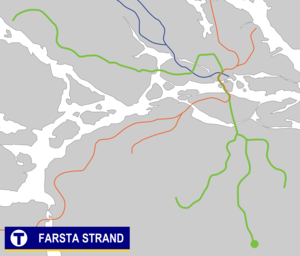
Farsta strand metro station is on the green line of the Stockholm metro, located in Farsta strand, Söderort. It is the end station for line 18. The station was opened on 29 August 1971 as the southern terminus of the extension from Farsta.[2] The distance to Slussen is 10.4 km (6 mi).
The Farsta strand commuter rail station is 200 metres away.
References
[edit]- ^ "Fakta om SL och regionen 2019" (PDF) (in Swedish). Storstockholms Lokaltrafik. p. 51. Archived (PDF) from the original on 27 December 2020. Retrieved 29 March 2021.
- ^ Schwandl, Robert. "Stockholm". urbanrail.
External links
[edit] Media related to Farsta strand station at Wikimedia Commons
- Images of Farstra strand station
