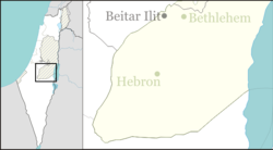
Eshkolot
Eshkolot | |
|---|---|
| Coordinates: 31°23′27″N 34°54′17″E / 31.39083°N 34.90472°E | |
| District | Judea and Samaria Area |
| Council | Har Hevron |
| Region | West Bank |
| Affiliation | Amana |
| Founded | 1982 |
| Founded by | Nahal |
| Population (2022)[1] | 623 |
Eshkolot (Hebrew: אֶשְׁכּוֹלוֹת, lit. Bunches) is a secular Israeli settlement in the southern Judaean Mountains of the West Bank. Located around five kilometers from Lahav, it is organized as a community settlement and falls within the jurisdiction of the Har Hevron Regional Council. In 2022 it had a population of 623.
The international community considers Israeli settlements in the West Bank illegal under international law, but the Israeli government disputes this.[2]
History
[edit]The village was first established in 1982 as a Nahal settlement and was turned over to civilians in 1991. The name of the city is taken from the well-known vineyards in Hebron.[citation needed]
Some of its residents own lands and are farming wheat, barley, grapes, olives, figs and pomegranates and even some few dates while others are working in other places, in particular Beersheba.[3] There are two local wineries currently being built.[when?]
See also
[edit]External links
[edit]- Eshkolot Negev Information Centre
References
[edit]- ^ "Regional Statistics". Israel Central Bureau of Statistics. Retrieved 21 March 2024.
- ^ "The Geneva Convention". BBC News. 10 December 2009. Retrieved 27 November 2010.
- ^ Har Hevron Jewish villages information Archived 2015-11-14 at the Wayback Machine
