Gongtang Township
Appearance
This article needs additional citations for verification. (October 2020) |
Gongtang | |
|---|---|
Township | |
| Tibetan transcription(s) | |
| • Tibetan | ཀོང་ཐང། |
| • Wylie transliteration | kong thang |
| Chinese transcription(s) | |
| • Traditional | 公塘乡 |
| • Pinyin | Gōngtáng Xiāng |
 Damxung County scenery | |
| Coordinates: 30°31′04″N 90°45′56″E / 30.51778°N 90.76556°E | |
| Country | China |
| Province | Tibet Autonomous Region |
| Prefecture | Lhasa Prefecture |
| County | Damxung County |
| Population (2003) | |
• Total | 4,800 |
| Time zone | UTC+8 (CST) |
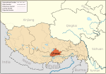
Gongtang (simplified Chinese: 公塘乡; traditional Chinese: 公塘鄉; pinyin: Gōngtáng Xiāng; Standard Tibetan: ཀོང་ཐང། ) is a township in Damxung County in the Lhasa Prefecture of Tibet, China. Established in 1960, in 1970 it became a township. It has a population of around 4800 and contains four village committees. The economy is based on animal husbandry, mainly shepherding goats, sheep, cattle and horses.[1]
Damxung Airport
[edit]Lhasa's first airport, Dancing Airport, was located just north of Gongtang from 1955 to 1965. After moving to Lhasa Gonggar Airport, the old airport site was partially occupied by a racetrack. All remaining infrastructure was removed with only footprint of runway present.
References
[edit]


