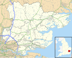
Kirby-le-Soken
Appearance
This article relies largely or entirely on a single source. (January 2009) |
| Kirby-le-Soken | |
|---|---|
 | |
Location within Essex | |
| Area | 0.590 km2 (0.228 sq mi) |
| Population | 1,387 (2018 estimate) |
| • Density | 2,351/km2 (6,090/sq mi) |
| OS grid reference | TM220220 |
| District | |
| Shire county | |
| Region | |
| Country | England |
| Sovereign state | United Kingdom |
| Post town | FRINTON-ON-SEA |
| Postcode district | CO13 |
| Police | Essex |
| Fire | Essex |
| Ambulance | East of England |
| UK Parliament |
|
Kirby-le-Soken is a village and former civil parish, now in the parish of Frinton and Walton, in the Tendring district in north-east Essex, England, which is mainly agricultural, but increasingly residential, near Frinton-on-Sea and Walton-on-the-Naze. In 2018 the built-up-area had an estimated population of 1387.[1] In 1931 the parish had a population of 836.[2] On 1 April 1934, the parish was abolished to form "Frinton and Walton", part also went to Thorpe-le-Soken.[3]
Kirby-le-Soken is in an area called The Sokens, isolated from Kirby Cross, Frinton-on-Sea, and Walton-on-the-Naze by fields.
References
[edit]- ^ "Kirby-le-Soken". City Population De. Retrieved 5 October 2020.
- ^ "Population statistics Kirby le Soken CP/AP through time". A Vision of Britain through Time. Retrieved 27 December 2021.
- ^ "Relationships and changes Kirby le Soken CP/AP through time". A Vision of Britain through Time. Retrieved 27 December 2021.
![]() Media related to Kirby-le-Soken at Wikimedia Commons
Media related to Kirby-le-Soken at Wikimedia Commons
- The Kirby-le-Soken History Pages
- Kirby-le-Soken Village Preservation Society
- Kirby-le-Soken War Memorial details
