Min Buri district
This article needs additional citations for verification. (June 2019) |
Min Buri
เขตมีนบุรี | |
|---|---|
 Khlong Saen Saep in the area of Khwan Riam Floating Market at sundown | |
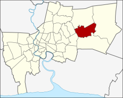
 Khet location in Bangkok | |
| Coordinates: 13°48′50″N 100°44′53″E / 13.81389°N 100.74806°E | |
| Country | Thailand |
| Province | Bangkok |
| Seat | Min Buri |
| Khwaeng | 2 |
| Area | |
• Total | 63.645 km2 (24.573 sq mi) |
| Population (2017) | |
• Total | 141,750[1] |
| • Density | 2,227.19/km2 (5,768.4/sq mi) |
| Time zone | UTC+7 (ICT) |
| Postal code | 10510 |
| Geocode | 1010 |
Min Buri (Thai: มีนบุรี, pronounced [mīːn būrīː]) is one of the 50 districts (khet) of Bangkok, Thailand. It is bounded by other Bangkok districts (from north clockwise): Khlong Sam Wa, Nong Chok, Lat Krabang, Saphan Sung, and Khan Na Yao. Min Buri is the fifth largest district in Bangkok.
History
[edit]The district was once a province established in 1901 during the reign of King Chulalongkorn. It consisted of Khlong Sam Wa district, Saen Saep district, Nong Chok district, and Chia Radap District (เจียรดับ). The name Min Buri (meaning 'city of fish') was chosen to go with the existing Thanyaburi province (meaning 'city of rice'). Economic problems during 1930-1931 caused the government to disband various organizations to reduce expenses. Min Buri Province was eliminated and turned into amphoe (district) Min Buri and Lat Krabang district of Bangkok, and Nong Chok district of Chachoengsao province. In 1957 part of Saen Saep subdistrict of Lat Krabang was transferred to Min Buri. In 1997, the northern part of Min Buri was split off to form the new Khlong Sam Wa District.
Administration
[edit]The district is divided into two sub-districts (khwaeng).
| No. | Name | Thai | Area (km2) |
Map |
|---|---|---|---|---|
1. |
Min Buri | มีนบุรี | 28.459 |

|
2. |
Saen Saep | แสนแสบ | 35.186
| |
| Total | 63.645
| |||
District council
[edit]The district council for Min Buri has seven members, who each serve four-year terms. Elections were last held on 30 April 2006. The results were as follows:
- Democrat Party: seven seats
Places
[edit]Museums
[edit]- Min Buri Local Museum (Formerly Min Buri City Hall)
- Small Barge Museum
Markets
[edit]- Min Buri Old Market
- Chatuchak Weekend Market 2, Min Buri
- Khwan Riam Floating Market
Public Park
[edit]- Rama IX Commemoration Park (สวนเฉลิมพระเกียรติ ร.9 มีนบุรี)
Temples
[edit]- Wat Bang Pheng Tai (วัดบางเพ็งใต้)
- Wat Bamphen Nuea (วัดบำเพ็ญเหนือ)
- Wat Saen Suk (วัดแสนสุข)
Education
[edit]This section needs expansion. You can help by adding to it. (March 2013) |
- Kasem Bundit University Romklao Campus[citation needed]
- Minburi Discovery Learning Library[citation needed]
- Setthabutbamphen School
- Satrisetthabutbamphen School
- Minburi Technical College
- Kanchanaphisek Technical College Mahanakorn
- Minprasatwittaya School[citation needed]
- Bromsgrove International School Thailand (early years campus and primary and secondary campus)[2]
- RIS Swiss Section-Deutschsprachige Schule Bangkok[3]
- Ruamrudee International School[4]
- Former schools
- Josuikan Bangkok International School[5] - Closed in 2024[6]
Sports
[edit]Industrial estate
[edit]- Bangchan Industrial Estate
References
[edit]- ^ "Population and House Report for Year 2017". Department of Provincial Administration, Ministry of Internal Affairs. Retrieved 2018-04-01. (Search page)
- ^ "Contact Us." Bromsgrove International School Thailand. Retrieved on 6 March 2013.
- ^ "Contact." RIS Swiss Section-Deutschsprachige Schule Bangkok. Retrieved on February 11, 2015. "RIS Swiss Section-Deutschsprachige Schule Bangkok
- ^ "Contact Us Archived 2013-03-18 at the Wayback Machine." Ruamrudee International School. Retrieved on 6 March 2013. "Ruamrudee International School"
- ^ "私立在外教育施設一覧" (). Ministry of Education, Culture, Sports, Science and Technology. Retrieved on March 1, 2015.
- ^ "Home". Josuikan Bangkok International School. Retrieved 2024-09-11.
