Map Of Ireland And ScotlandMap Of England And IrelandEngland Travel MapMap Of The UkUk MapsDetailed Map Of EnglandMap Of UkMap Of EnglandMap Of ScotlandUnited Kingdom mapUnited Kingdom map126
Uk RegionsMap Of Uk Regions And CountiesDetailed Uk Regional MapUk Counties MapEngland Counties MapMap Of Scotland RegionsMap Of Great BritainUnited Kingdom MapMap Of BritainUk Regions189
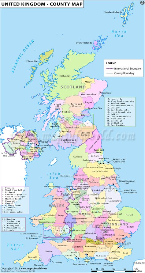
United Kingdom Of The Netherlands MapMap Of England United KingdomMedieval Northern Europe MapMedieval Netherlands MapKortrijk City MapUnited Kingdom MapMap Of Great BritainMap Of BritainCounties Of EnglandUK Counties Map | Map of Counties In UKUK Counties Map for free use, download, and print. Map showing the location of all the counties in the United Kingdom.2.5k
British Flag MapHistorical Map Of BritainLiterary Map Of BritainMap Of Blue-eyed BritainUnited Kingdom MapMap Of Great BritainMap Of BritainKingston Upon HullBen NevisBritish Flag Map121
Blank Map Of Uk And IrelandPrintablePrintable Map Of Uk And IrelandUk And Ireland Map PrintableMap Of Uk And Ireland PrintableBlank Map Of Uk And Ireland71
Printable Map Of UkUk Map OutlineBlank Map Of United KingdomEngland Blank MapBlack And White Map Of EnglandUk OutlineUnited Kingdom MapMap Of Great BritainMap Of BritainPrintable Map Of Uk58
Detailed Map Of EnglandEngland Map OutlineMap Of Uk United KingdomEngland Counties MapArmada Map Of EnglandNorthern Ireland MapUnited Kingdom CountriesLeeds EnglandUnited Kingdom MapConstituent Countries Of The United KingdomThe United Kingdom has four constituent countries, England, Wales, Scotland, and Northern Ireland. The UK came together over several centuries.102
Map Of Great Britain And Ireland With CitiesMap Of Great Britain And Ireland With TownsMap Of Scotland With Numbered LocationsAncient Map Of Kingdome Of ScotlandNewcastle IrelandPlaiskin Cliff Ireland MapMap Of Great BritainUnited Kingdom MapSwansea BayEngland Home Pageengland | england is the largest of the three political divisions within the ...1
Map Of Uk And Ireland With CitiesDetailed Map Of Uk And IrelandMap Of Great Britain And IrelandMap Of Republic Of IrelandMap Of Uk RiversWorld Map EuropeMap Of Great BritainMap Of BritainAncient IrelandMap of UK and IrelandMap of UK and Ireland381
England And WalesEngland GeographyEngland Ireland Scotland WalesMap Of The UkUk MapsMap Of UkBritain MapMap Of EnglandMap Of ScotlandMap Of The United Kingdom | Classical FinanceThe UK comprises four countries: England, Scotland, Wales and Northern Ireland. It is a constitutional monarchy with a parliamentary democracy, with its capital city being London.261
United Kingdom Physical Map Retro ColorsBritain MapMap Of EnglandUk Geography MapUk Map AestheticUk MapUk Physical MapUk Physical Geography MapUk Physical GeographyUnited Kingdom Physical Map Retro ColorsBuy United Kingdom Physical Map Retro Colors by Cartarium on GraphicRiver. United Kingdom Physical Map. Retro colors. – highly detailed vector illustration. Image contains layers with shaded c...321
Map Of Uk CitiesMap Of England United KingdomUk Map Showing CitiesUnited Kingdom Physical MapUnited Kingdom Historical MapMap Of Great Britain CountiesUnited Kingdom MapMap Of BritainVisit UkUk Map and Other 97 Related British MapsUK Map showing international boundaries and other important physical features of the United Kingdom. Browse through our wide collection of British Maps to know more about the United Kingdom.4
Map Of England United KingdomUnited Kingdom Historical MapBritish Commonwealth MapBritish Colony MapMap Of Anglo Saxon BritainOxford LondonBelfast IrelandUnited Kingdom MapMap Of Britainmap uk - Neu Pin HDUK Road Map | United Kingdom Highway Map UK Road Map Map Catalogue :: A-Z Maps Please select a region Map Of Uk | Travel Read More51
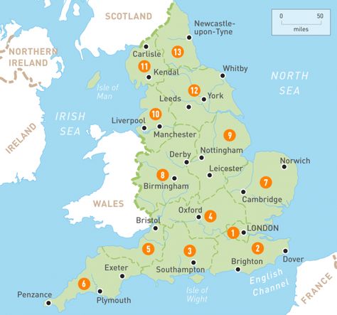
Oxford LondonUnited Kingdom MapMap Of BritainEngland MapTourist MapTourist OfficeEngland UkEurope MapTourist InformationUK map | Map of England | map of England UK | Mapa UKUK map Map of England The United Kingdom (UK) region map shows the surrounding regions and provinces of the United Kingdom (UK)5
Study British History MapsHistorical Map Of BritainMap Of British India During British RuleMap Of Great BritainUnited Kingdom MapMap Of BritainEngland MapKingston Upon HullLiving In EnglandStudy British History MapsUnited Kingdom Map Overview21
Maps Of EnglandUk MapsMap Of UkMap Of EnglandUk Map With Counties And CitiesUk MapMap Of Uk RegionsRegions Of England MapMap Of England Showing CountiesMaps Of EnglandCounties and county towns3
British Commonwealth Countries MapAncient Map Of LeicestershireAncient British MapsWeird Town NamesAntique Map Of British EmpireVintage Map Of The British IslesOdd NamesMap Of BritainUk HistoryBritish Commonwealth Countries Map305
Flags Of The UkMap Of The UkMap Of UkUk MapUk Map ClipartGeography Lesson PlansUnited Kingdom MapMap Of Great BritainGeography ProjectUK MapThis poster features an illustrated, labelled map of the UK and can be a great help when developing your children's place knowledge. Ideal for display in your classroom, this UK map poster features the four flags of Scotland, England, Wales and Northern Ireland. You'll also find the capital cities of these countries clearly labelled too.79
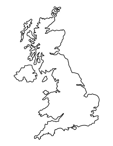
Printable Map Of UkBritish Map OutlineEngland Map OutlineBlack And White Map Of EnglandBritish Isles Map IllustrationUk OutlineEmbroidery MapBritish Isles MapUnited Kingdom MapPrintable United Kingdom TemplateFree printable united kingdom pattern. Cut out the shape and use it for coloring, crafts, stencils, and more.149
Map Of England And Wales With VillagesRocque Map Of EnglandPhysical Map Of England And WalesEngland Counties MapMap Of Southern EnglandBristol LondonWales MapBristol EnglandEngland MapMap of England | England Regions | Rough Guides | Rough GuidesEngland - A little country with an illustrious history, England’s dynamic cities, sleepy villages, lush green moorlands and craggy coastlines create a rich cultural and natural landscape. Whether wolfing down tasty seaside fish and chips, downing a …32