Papers by Ali Yılmaz

Turkish Journal of Earth Sciences, May 10, 2019
Introduction A simplified paleotectonic map of the Eastern Anatolian Plateau and its surroundings... more Introduction A simplified paleotectonic map of the Eastern Anatolian Plateau and its surroundings is seen in Figure 1. The Eastern Anatolian Plateau is constrained by the North Anatolian-Lesser Caucasus Suture (NALCS) (and/or İzmir-Ankara-Erzincan suture of Turkey) to the north and the Southeastern Anatolian Suture (SEAS) (and/or Bitlis-Zagros Suture) to the south. Continental metamorphic rock units, ophiolites with mélanges of the North Anatolian Ophiolitic Belt (NAOB) and Southeastern Anatolian Ophiolitic Belt (SAOB), and forearc units of the Eastern Pontide Arc (EPA) represent the pre-Maastrichtian to Quaternary sequence in the region. The Eastern Anatolian Basins (EAB) have been interpreted, in general, as intermountainous basins lying between metamorphic massifs (Kurtman and Akkuş, 1971) and/or intermountainous with pull-apart basins (Şaroğlu and Yılmaz, 1986). Up to rather recent reassessments, the pre-Neogene basement was interpreted as consisting largely of accretionary complexes, formed at the junction of several crustal blocks with irregular margins, similar to the Makran accretionary wedge in Iran (Şengör et al., 2003, 2008). This interpretation was brought into question by Yılmaz et al. (2010) and mainly continental basement was then suggested for the base of the East Anatolian Region (EAR). On the basis of Topuz et al. (2017), the Neoproterozoic-Early Paleozoic provenance of detrital zircons in the metaquartzite in the region was seen to indicate a substantial component of continental basement beneath the Neogene to Quaternary cover, as well. There are several studies of some individual basins in the region (

Turkish Journal of Earth Sciences, 2004
The Tokat Massif consists of a pre-Jurassic metamorphic complex that crops out widely between Ama... more The Tokat Massif consists of a pre-Jurassic metamorphic complex that crops out widely between Amasya and Refladiye in the western part of eastern Pontides, and which can be correlated with the Karakaya Complex of the western Pontides. This complex is named the Tokat Group, and is divided into two main units, namely, the Turhal Metamorphics and Devecida¤ Mélange. The Turhal Metamorphics form a volcano-sedimentary sequence in the northern part of the Tokat Massif. The lower level of the formation is made up of gneiss, amphibolite and mica schists, whereas the upper part is represented by an alternation of mica schist, phyllite, metaclastic rocks, metabasite and marble, which probably reflects an arc association. The Devecida¤ Mélange is characterised by a metavolcano-sedimentary olistostrome, which forms the southern part of the massif. This unit is quite heterogeneous and reflects, in places, a subduction mélange and/or a fore-arc sequence. The Devecida¤ Mélange may have formed in a setting between a subduction zone and a fore-arc. The units of the Tokat Massif can be traced along the eastern Pontides and also along the North Anatolian Ophiolitic Belt. These units have been accreted to the mélange prism as tectonic slices along the North Anatolian Ophiolite Belt before the Campanian. Some of Late Cretaceous ophiolitic mélange slices also crop out in the Tokat Group as E-W-trending tectonic slices. The ophiolites and ophiolitic mélange are believed to have been emplaced both to the north and to the south during the Late Cretaceous. The north-vergent thrusts have been later realigned into south-dipping thrusts during a neotectonic phase.

Turkish Journal of Earth Sciences
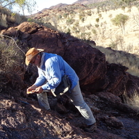
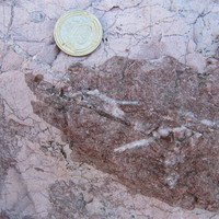
The Eastern Anatolian Plateau (EAP), approximately 2000 m above sea level, is located between the... more The Eastern Anatolian Plateau (EAP), approximately 2000 m above sea level, is located between the Eastern Pontides to the north, the Arabian Platform to the south, and the Iranian Plateau to the east. It is characterized by approximately 6 km-thick Maastrichtian to Quaternary volcano-sedimentary cover which unconformably overlies continental and oceanic basement units. Overall, the outcrops of the pre-Maastrichtian basement are rare and include both continental and oceanic units. This led to drastically different interpretations of the nature of the pre-Maastrichtian basement as (i) the oceanic accretionary complex or (ii) continental crust and overlying ophiolitic mélange. This synthesis deals with the relationships between continental and oceanic units in light of the recent geological, geophysical, and geochemical studies. Geophysical studies consistently indicate the presence of a spatially thickened continental crust with a lateral variation ranging from 38 to 52 km. Seismological models estimate lithospheric thicknesses to be in the range of 70-80 km, suggesting the presence of a rather thinned lithosphere. The pre-Maastrichtian continental units include late Cretaceous high-T/low-P metamorphic rocks, which are intruded by late Cretaceous basic to acidic intrusions at the base. Protoliths of the high-T/low-P metamorphic rocks can be closely correlated with those of the Anatolide-Tauride Block, probably representing the metamorphosed equivalents of the Anatolide-Tauride Block. The continental crustal nature is also testified by the presence of metasyenite to-granite with igneous crystallization ages of 430-440 Ma. The Late Cretaceous ophiolitic mélanges with locally intact tracks of ophiolite and overlying forearc deposits tectonically sit over the Late Cretaceous high-T/low-P metamorphic rocks. These ophiolitic mélanges probably form part of the North Anatolian ophiolitic belt, related to the İzmir-Ankara-Erzincan suture. Maastrichtian to Quaternary volcano-sedimentary rocks overlie both the continental crustal and tectonically overlying oceanic units, representing probably collisional and postcollisional basin fills. Available geological, geochemical, and geophysical data suggest a pre-Maastrichtian basement that comprises a continental crustal domain and an overlying ophiolitic mélange beneath the Masstrichtian to Quaternary cover.
Geodinamica Acta, 2010
The Eastern Anatolian Plateau (EAP) of Turkey, with an elevation ranging from 1700 to 2000 m, is ... more The Eastern Anatolian Plateau (EAP) of Turkey, with an elevation ranging from 1700 to 2000 m, is located between the Eastern Pontide Arc to the north and the Arabian Platform to the south. In this region, pre-Maastrichtian tectonic units representing the crust crop out in only a few localities. As they are covered by Maastrichtian-Quaternary rock units, it is difficult

The aim of the presented study is to review the ophiolites and ophiolitic melanges of Turkey and ... more The aim of the presented study is to review the ophiolites and ophiolitic melanges of Turkey and their importance for constraints on the evolution of the region. On the basis of the existing data, the ophiolitic associations of Turkey are classified into three main groups. 1. Group comprises pre-Alpine ophiolites and melanges located on the southern edge of the Istanbul zone. These associations are in Pre-Jurassic age, and represent ophiolitic sequences of the Pontide Suture zone. The Karakaya complex represents pre-Alpine ophiolitic melange and developed during the emplacement of the pre-Alpine ophiolites. The opening and closing ages and polarity of the Paleotethys is still a question. 2. Group can be divided into two sub-belts and they are the Northern-Northeastern and the Southern sub belt. They are allied to the North Anatolian Ophiolitic Belt (NAOB). The northern-northeastern subbelt extends from Izmir to eastward, continuing as the Ankara-Erzincan zone and as the Sevan...

The study area covers the Caucasus and the northeastern Turkey. Tectonic zones of the Caucasus an... more The study area covers the Caucasus and the northeastern Turkey. Tectonic zones of the Caucasus and their continuations in the northeastern Turkey, and also the relationships, lateral variations, similarities and differences of the both district, will be presented. On the basis of the main geologic characteristics, the rock units of the Caucasus are divided into the tectonic zones. Each zone has pre-Liassic, Liassic and post Liassic units reflecting different geotectonic environment. The northern part named as the Great Caucasus, the southern part as the Lesser Caucasus, median part as the Transcaucasus of the Caucasus was bordered by the Scythian platform to the north and by the Iranian platform to the south. The tectonic zones of the Great Caucasus lie from north to south are presented below: the Laba-Malka zone (the Bechasinian Subzone and the Forerange Subzone), the Main Range zone, the Southern Slope zone. The Gagra-DJava zone and the Drizula massif and its covers are situated to the north, the Somcheti-Kafan (Karabakh) zone to the south and the Adjara-Trialetian and Talysh zones which are the continuation of each other are between the zones of the Transcaucasus. The ophiolitic belt (the Sevan-Akeran Ophiolitic zone to the north, the Vedi Ophiolitic zone to the south) of the Lesser Caucasus and the Miskhan-Zangezur zone and the Araks zone of the northern part of Iranian platform have been differentiated. The Caucasus tectonic zones are bordered by the overthurst planes dipping 70-80 degrees to the north. The Oligocene-Recent molasse showing enormous lateral and vertical facial changes, sits upon the rocks of the tectonic zone conformably or unconformably, in places. The results, presented below, can be obtained by the correlation of the Caucasus tectonic zones and tectonic zones of northeastern Turkey: 1-The tectonic zones of the Great Caucasus and northern part of the Transcaucasus can not be followed in the northeastern Turkey. 2-The Adjara-Trialetian zone continues along the Black Sea Shores. 3-The Somcheti-Kafan (Karabakh) zone, which is southern part of the Transcaucasus corresponds to the Pontian zone. But, considerable differences on the basis of the stratigraphic sequence and facial changes are observed in the both sides of the zone. 4-The Lesser Caucasus ophiolitic belt corresponds to the North Anatolian ophiolitic belt. There are two subzones, one of them is to the north and another is to the south, showing similarities in both side of the belt. 5-Iranian platform of the Lesser Caucasus corresponds to the Taurus platform, in general. Pre-Liassic Miskhan-Zangezur zone of Iranian platform corresponds to the Central and East Anatolian massifs the Araks zone to the Taurus zone respectively. If the corresponding tectonic zones of the Caucasus and northeastern Turkey are correlated, considerable facial changes as well as the similarities are observed. A lot of the differences result in the lateral and vertical changes of the zones.

Gondwana Research, 2021
Abstract The Anatolide-Tauride block in the Tethyan belt represented passive northern continental... more Abstract The Anatolide-Tauride block in the Tethyan belt represented passive northern continental margin of Gondwana throughout Paleozoic time. In this paper, we report on a relatively large amphibolite-facies metaquartz-syenite to -granite complex (~ 60 km2) in the Eastern Anatolia, the easternmost part of the Anatolide-Tauride block. Igneous textures in the metaintrusive complex are variably preserved. The preserved igneous minerals include mesoperthite + quartz ± aegirine-augite ± sodic amphibole ± calcic amphibole ± biotite and ± allanite. Mesoperthite is the sole feldspar in well-preserved igneous textures, suggesting the hypersolvus nature of the original quartz syenite to granite. In the well-recrystallized samples, mesoperthite is partially or totally replaced by discrete grains of plagioclase and K-feldspar. U Pb dating on igneous zircons from three samples yielded Silurian igneous crystallization ages (430–440 Ma). All rock types have typical geochemical characteristics of A-type syenite to granite with relatively high abundances of FeO*, Na2O, K2O, Nb, Ga, Zr, Ce, and Zn, and low abundances of MgO, CaO and Sr, resulting in high ratios of Fe/Mg and Ga/Al. Geochemical features such as (i) the absence of negative Nb Ta anomalies on multielement variation diagrams, (ii) the enrichment of Nb and Ce relative to Y, and (iii) Y/Nb, Yb/Ta and Ce/Nb ratios similar to those in ocean island basalts point to A1-type syenite and granite which are thought to be differentiates of ocean island basaltic magmas. Estimated magma temperatures based on zirconium saturation range from 850 to 990 °C, indicating derivation of the original quartz syenite and granite from high-temperature juvenile magmas. Initial eHf values of the igneous zircons from two samples are 2.59 ± 1.14 and 2.30 ± 1.29, while δ18O values of the zircons range from 5.41 to 7.32‰ with a median of 6.50 ± 0.48‰. All these isotopic characteristics suggest that the quartz syenite to granite were derived from high-temperature mantle magmas with insignificant crustal assimilation. The Late Ordovician-Silurian A-type igneous rocks in the northern part of the Anatolide-Tauride block were probably related to a rifting event at the northern margin of Gondwana, leading to the opening of the Paleo-Tethys. This interpretation is also supported from (i) regional geological features of the Early Paleozoic sedimentary successions suggestive of extensional setting during the Late Ordovician-Silurian, (ii) the presence of Silurian anorogenic magmatism in continental blocks detached from Gondwana during Early Paleozoic time, and (iii) the presence of Silurian deep sea sedimentary blocks in Paleo-Tethyan accretionary complexes.

Bulletin of the Mineral Research and Exploration, 1988
İnceleme alanı, Erzurum'un güneydoğusunda Hınıs-Tekman ve Karayazı arasında yer almaktadır. Y... more İnceleme alanı, Erzurum'un güneydoğusunda Hınıs-Tekman ve Karayazı arasında yer almaktadır. Yapılan çalışmada yörenin bazı jeoloji özelliklerinin incelenmesi amaçlanmıştır. İnceleme alanında en alttaki kayalar, alttan üste doğru gnays, amfibolit, şist ve mermer ardalanmasından oluşur ve ofiyolitli karmaşık yaygısının altından tektonik bir pencere biçiminde yüzeylenir. Ofiyolitli karmaşık genellikle diyabaz, gabro ve yer yer serpantinit ile peridotitten oluşmaktadır. Asidik sokulumlar ise hem metamorfitleri hem de karmaşığı keser. Mestrihtiyen ile Pliyosen yaş aralığındaki kayalar, birbirini düzenli izleyen transgresif ve regresif dizilerden oluşur ve daha yaşlı birimleri uyumsuzlukla örter. İnceleme alanı, Orta (?) Üst Miyosen sırasında karasal niteliğe bürünmüştür. Tortul örtünün Oligosen yaşlı istifinde, ince andezitik bazalt arakatkılar, Miyosen-Pliyosen istifinde ilkin dasit-andezit arası bileşimde volkanitier, sonra sıra ile andezitik bazalt ve bazaltik piroklastitler ve la...

Inceleme alani, Dogu Toroslar'in kuzey kesiminde ve Sivas havzasinin guney kenarinda Divrigi,... more Inceleme alani, Dogu Toroslar'in kuzey kesiminde ve Sivas havzasinin guney kenarinda Divrigi, Sincan ve Kangal arasindaki bir bolgede yer almaktadir. Bu calismada yorenin temel jeolojik ozellikleri isiginda yapisal evriminin incelenmesi amaclanmistir. Inceleme alaninin temeli, Toroslarin goreli otoktonunu olusturan Alt Paleozoyik yasli kirintili kayalar, Ust Paleozoyik-Mesozoyik yasli platform turu karbonatlar, allokton konumlu Ust Kretase yasli ofiyolitli karisik ve Jura yasli ofiyolit toplulugundan olusan bir mozayikle temsil edilmektedir. Bu mozayigin uzerine Maastrihtiyen-Kuvaternef araliginda olusmus bir ortu, acili uyumsuzlukla gelmektedir. Ortunun en alt duzeyi polijenik cakiltasi ile baslayan Maastrihtiyen yasli volkano-tortul diziden olusmaktadir. Paleosen'de Divrigi Granitoyidleri'nden olusan intruzif kayalar, temeli olusturan tektonik birimleri ve Maastrihtiyen yasli volkano-tortul diziyi kesmistir. Daha sonra, alt duzeylerden ust duzeylere dogru sira i...
Türkiye Jeoloji Bülteni / Geological Bulletin of Turkey
Oltu-Balkaya havzası, Pontid Yayı ve Anadolu-Toros Platformu'nun arasında Üst Maastrihtiyen'den i... more Oltu-Balkaya havzası, Pontid Yayı ve Anadolu-Toros Platformu'nun arasında Üst Maastrihtiyen'den itibaren gelişen çarpışma (ilk çarpışma-soft-collision) ile oluşmaya başlamıştır ve Maastrihtiyen-Erken Eosen döneminde çarpışmalı bir önülke havzası olarak evrim geçirmiştir. Bu dönemde alttan üste doğru sırasıyla karbonat arakatkılı türbiditik karasal kırıntılılar, denizel delta çökelleri ve denizel kırıntılılar çökelmiştir. Sonuç olarak, Oltu-Balkaya havzası, Maastrihtiyen-Erken Eosen döneminde çarpışma evresi, Orta Eosen-Erken Pliyosen döneminde çarpışma sonrası ve Geç Pliyosen'den Günümüze kadar (Neotektonik dönem), doğrultu atımlı rejimin egemen olduğu üstüste gelişmiş bir havzayı temsil etmektedir.

Journal of Asian Earth Sciences, 2006
The ENE-SSW trending Sivas Basin is located at the easternmost wedge-like tip of the Central Anat... more The ENE-SSW trending Sivas Basin is located at the easternmost wedge-like tip of the Central Anatolian Block and exhibits characteristics of two other basins, one in west-central Anatolia and the other in eastern Anatolia. The Sivas Basin started to form within a collisional mosaic during Maastrichtian time with the Pre-Maastrichtian basement, the latter composed of continental metamorphic rocks, Jurassic-Lower Cretaceous platform carbonates of the Tauride Belt, and ophiolites and ophiolitic melánge derived from closure of the northern branch of Neo-Tethys. Similar Tertiary basins were developed on comparable collisional mosaics in other parts of Anatolia. The Sivas Basin is asymmetrical in both the longitudinal and transversal directions. Its infill is dominated by a thick Maastrichtian-Tertiary shallow marine-continental succession resting unconformably on Pre-Maastrichtian basement rocks and dissected into several subbasins. This infill consists of post-collisional deposits which overlie paleotectonic units unconformably and each subbasin is bounded by northeastsouthwest trending oblique-slip faults exhibiting dominant strike-slip. The subbasins are characterized by contrasting stratigraphic successions, although all are composed of interstratified continental and shallow-marine facies. Both the northern and southern margins of the subbasins include Upper Eocene olistostromes containing mega-blocks of varied origin. The latter are sourced in paleotectonic units and were reworked in a shallow-marine depositional setting. The fill of the middle subbasins exhibits strong vertical and lateral facies changes, characterized by local and regional unconformities and includes continental to shallow-marine volcanic rocks. This basin was deformed under north-south-directed compression during Late Pliocene-Quaternary times during the neotectonic phase of deformation. This deformation divided the basin into new, small-scale, mainly pull-apart subbasins including those at İmranlı, İşhanı, Altınyayla and Ş arkışla. From stratigraphic and structural correlations, a post collisional intra-continental basin model for the Sivas Basin is preferred.
Geology
The East Anatolian plateau (Turkey) is extensively covered by Neogene to Quaternary volcanic-sedi... more The East Anatolian plateau (Turkey) is extensively covered by Neogene to Quaternary volcanic-sedimentary rocks, and is characterized by an attenuated lithospheric mantle. Its pre-Neogene basement is commonly considered to consist entirely of Late Cretaceous to Oligocene oceanic accretionary complexes, formed at the junction of several continental blocks. Here we report on three main exposures of the pre-Neogene basement in this region. The exposed areas consist mainly of amphibolite-to granulite-facies metamorphic rocks, including marble, amphibolite, metapelite, metagranite, and metaquartzite. An upper amphibolite-to granulitefacies domain is equilibrated at similar to 0.7 GPa and similar to 800 degrees C at 83 +/- 2 Ma (2 sigma). U-Pb dating of magmatic zircons from the metagranite yielded a Late Ordovician-early Silurian protolith age (444 +/- 9 Ma, 2 sigma). The detrital zircons from one metaquartzite point to a Neoproterozoic-early Paleozoic provenance. Ophiolitic rocks tectonically sit on the metamorphic rocks. Both the metamorphic and ophiolitic rocks are in turn unconformably covered by lower Maastrichtian clastic rocks and reefal limestones, suggesting that the whole exhumation process and juxtaposition with the ophiolitic rocks had occurred by the early Maastrichtian. Several lines of evidence, such as (1) the absence of any indication of a former high-pressure metamorphism in the metamorphic rocks, (2) the allochthonous nature of the ophiolitic rocks, (3) the presence of metagranite with a Late Ordovician-early Silurian protolith age, and (4) the Neoproterozoic- early Paleozoic provenance of detrital zircons in the metaquartzite (in contrast to the dominance of late Paleozoic-Mesozoic crystalline rocks in the adjacent continental blocks) indicate a substantial component of continental basement beneath the Neogene to Quaternary cover. Thus, the loss of the lithospheric mantle probably resulted from lithospheric foundering processes beneath the plateau, rather than just slab steepening and break-off.

An analysis of the Phanerozoic evolution of the Black Sea region (Fig.,1) shows that at least fro... more An analysis of the Phanerozoic evolution of the Black Sea region (Fig.,1) shows that at least from the Paleozoic onwards, the region evolved as an active margin of the Northern Tethys comprising oceanic and continental back-arc systems. Counterparts of many of the Caucasian-Eastern Pontian structural units can be traced in Western Pontides, Balkans and Carpathians. Continuous development of the PaleothethysTethys throughout the Paleozoic-Mesozoic-Early Cenozoic is indicated by the presence of Paleozoic to Upper Cretaceous oceanic rocks, of the Lower Paleozoic to Eocene supra-subductional magmatic assemblages and by an uninterrupted deep marine Devonian to Late Eocene sedimentation in the Dizi basin of the Greater Caucasus. In this connection, the Dizi series represent interarc or back-arc associations. The whole region seems to represent a West Pacific type long living accretionary assemblage of the Lesser Caucasian North Anatolian-Vardar branch of the Tethys.
Geoscience Frontiers, 2014

Geodinamica Acta, 2001
The east Anatolian plateau and the Lesser Caucasus are characterised and shaped by three major st... more The east Anatolian plateau and the Lesser Caucasus are characterised and shaped by three major structures: (1) NWand NE-trending dextral to sinistral active strike-slip faults, (2) N-S to NNW-trending fissures and /or Plio-Quaternary volcanoes, and (3) a 5-km thick, undeformed Plio-Quaternary continental volcanosedimentary sequence accumulated in various strike-slip basins. In contrast to the situation in the east Anatolian plateau and the Lesser Caucasus, the Transcaucasus and the Great Caucasus are characterised by WNW-trending active thrust to reverse faults, folds, and 6-km thick, undeformed (except for the fault-bounded basin margins) continuous Oligocene-Quaternary molassic sequence accumulated in actively developing ramp basins. Hence, the neotectonic regime in the Great Caucasus and the Transcaucasus is compressional-contractional, and Oligocene-Quaternary in age; whereas it is compressional-extensional, and Plio-Quaternary in age in the east Anatolian plateau and the Lesser Caucasus. Middle and Upper Miocene volcano-sedimentary sequences are folded and thrust-to-reverse-faulted as a result of compressionalcontractional tectonic regime accompanied by mostly calc-alkaline volcanic activity, whereas Middle Pliocene-Quaternary sequences, which rest with angular unconformity on the pre-Middle Pliocene rocks, are nearly flat-lying and dominated by strike-slip faulting accompanied by mostly alkali volcanic activity implying an inversion in tectonic regime. The strike-slip faults cut and displace dykes, reverse to thrust faults and fold axes of Late Miocene age up to maximum 7 km: hence these faults are younger than Late Miocene, i.e., these formed after Late Miocene. Therefore, the time period between late Serravalian (∼ 12 Ma) continent-continent collision of Arabian and Eurasian plates and the late Early Pliocene inver-sion in both the tectonic regime, basin type and deformation pattern (from folding and thrusting to strike-slip faulting) is here termed as the Transitional period. Orientation patterns of various neotectonic structures and focal mechanism solutions of recent earthquakes that occurred in the east Anatolian plateau and the Caucasus fit well with the N-S directed intracontinental convergence between the Arabian plate in the south and the Eurasian plate in the north lasting since Late Miocene or Early Pliocene in places. © 2001 Éditions scientifiques et médicales Elsevier SAS East Anatolian Plateau / Caucasus / neotectonics / ramp basin / strike-slip basin

The East Anatolian plateau (Turkey) is extensively covered by Neogene to Quaternary volcanic-sedi... more The East Anatolian plateau (Turkey) is extensively covered by Neogene to Quaternary volcanic-sedimentary rocks, and is characterized by an attenuated lithospheric mantle. Its pre-Neogene basement is commonly considered to consist entirely of Late Cretaceous to Oligocene oceanic accretionary complexes, formed at the junction of several continental blocks. Here we report on three main exposures of the pre-Neogene basement in this region. The exposed areas consist mainly of amphibolite-to granulite-facies metamorphic rocks, including marble, amphibolite, metapelite, metagranite, and metaquartzite. An upper amphibolite– to granulite-facies domain is equilibrated at ~0.7 GPa and ~800 °C at 83 ± 2 Ma (2σ). U-Pb dating of mag-matic zircons from the metagranite yielded a Late Ordovician–early Silurian protolith age (444 ± 9 Ma, 2σ). The detrital zircons from one metaquartzite point to a Neoproterozoic–early Paleozoic provenance. Ophiolitic rocks tectonically sit on the metamorphic rocks. Both the metamorphic and ophiolitic rocks are in turn unconformably covered by lower Maastrichtian clastic rocks and reefal limestones, suggesting that the whole exhumation process and juxta-position with the ophiolitic rocks had occurred by the early Maastrichtian. Several lines of evidence, such as (1) the absence of any indication of a former high-pressure metamorphism in the metamorphic rocks, (2) the allochthonous nature of the ophiolitic rocks, (3) the presence of metagranite with a Late Ordovician–early Silurian protolith age, and (4) the Neoprotero-zoic–early Paleozoic provenance of detrital zircons in the metaquartzite (in contrast to the dominance of late Paleozoic–Mesozoic crystalline rocks in the adjacent continental blocks) indicate a substantial component of continental basement beneath the Neogene to Quaternary cover. Thus, the loss of the lithospheric mantle probably resulted from lithospheric foundering processes beneath the plateau, rather than just slab steepening and break-off.
Conference Presentations by Ali Yılmaz

Turkish Journal of Earth Sciences, 2023
The Eastern Anatolian Plateau (EAP), approximately 2000 m above sea level, is located between the... more The Eastern Anatolian Plateau (EAP), approximately 2000 m above sea level, is located between the Eastern Pontides to the north, the Arabian Platform to the south, and the Iranian Plateau to the east. It is characterized by approximately 6 km-thick Maastrichtian to Quaternary volcano-sedimentary cover which unconformably overlies continental and oceanic basement units. Overall, the outcrops of the pre-Maastrichtian basement are rare and include both continental and oceanic units. This led to drastically different interpretations of the nature of the pre-Maastrichtian basement as (i) the oceanic accretionary complex or (ii) continental crust and overlying ophiolitic mélange. This synthesis deals with the relationships between continental and oceanic units in light of the recent geological, geophysical, and geochemical studies. Geophysical studies consistently indicate the presence of a spatially thickened continental crust with a lateral variation ranging from 38 to 52 km. Seismological models estimate lithospheric thicknesses to be in the range of 70-80 km, suggesting the presence of a rather thinned lithosphere. The pre-Maastrichtian continental units include late Cretaceous high-T/low-P metamorphic rocks, which are intruded by late Cretaceous basic to acidic intrusions at the base. Protoliths of the high-T/low-P metamorphic rocks can be closely correlated with those of the Anatolide-Tauride Block, probably representing the metamorphosed equivalents of the Anatolide-Tauride Block. The continental crustal nature is also testified by the presence of metasyenite to-granite with igneous crystallization ages of 430-440 Ma. The Late Cretaceous ophiolitic mélanges with locally intact tracks of ophiolite and overlying forearc deposits tectonically sit over the Late Cretaceous high-T/low-P metamorphic rocks. These ophiolitic mélanges probably form part of the North Anatolian ophiolitic belt, related to the İzmir-Ankara-Erzincan suture. Maastrichtian to Quaternary volcano-sedimentary rocks overlie both the continental crustal and tectonically overlying oceanic units, representing probably collisional and postcollisional basin fills. Available geological, geochemical, and geophysical data suggest a pre-Maastrichtian basement that comprises a continental crustal domain and an overlying ophiolitic mélange beneath the Masstrichtian to Quaternary cover.


Uploads
Papers by Ali Yılmaz
Conference Presentations by Ali Yılmaz