Saint-Polycarpe, Quebec
From Infogalactic: the planetary knowledge core
| Saint-Polycarpe | |
|---|---|
| Municipality | |
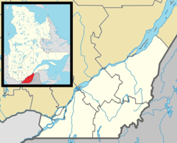
Location within Vaudreuil-Soulanges RCM. |
|
| Location in southern Quebec. | |
| Coordinates: Lua error in package.lua at line 80: module 'strict' not found.[1] | |
| Country | |
| Province | |
| Region | Montérégie |
| RCM | Vaudreuil-Soulanges |
| Constituted | December 31, 1988 |
| Government[2][3] | |
| • Mayor | Normand Ménard |
| • Federal riding | Salaberry—Suroît |
| • Prov. riding | Soulanges |
| Area[2][4] | |
| • Total | 70.90 km2 (27.37 sq mi) |
| • Land | 69.97 km2 (27.02 sq mi) |
| Population (2011)[4] | |
| • Total | 1,969 |
| • Density | 28.1/km2 (73/sq mi) |
| • Pop 2006-2011 | |
| • Dwellings | 829 |
| Time zone | EST (UTC−5) |
| • Summer (DST) | EDT (UTC−4) |
| Postal code(s) | J0P 1X0 |
| Area code(s) | 450 and 579 |
| Highways | |
| Website | www |
Saint-Polycarpe is a Quebec municipality located in the Vaudreuil-Soulanges Regional County Municipality in the Montérégie region west of Montreal and just east of the Quebec-Ontario border. It was named for Polycarp, a 2nd-century bishop of Smyrna. The population as of the Canada 2011 Census was 1,969.
While a parish during the 18th century, its territory included portions of what is now part of Saint-Zotique located south of Autoroute 20 that links Montreal and Toronto.
Contents
Demographics
Population
| Historical Census Data - Saint-Polycarpe, Quebec[7] | ||||||||||||||||||||||||||
|---|---|---|---|---|---|---|---|---|---|---|---|---|---|---|---|---|---|---|---|---|---|---|---|---|---|---|
|
|
|
||||||||||||||||||||||||
Language
| Canada Census Mother Tongue - Saint-Polycarpe, Quebec[7] | ||||||||||||||||||
|---|---|---|---|---|---|---|---|---|---|---|---|---|---|---|---|---|---|---|
| Census | Total |
French
|
English
|
French & English
|
Other
|
|||||||||||||
| Year | Responses | Count | Trend | Pop % | Count | Trend | Pop % | Count | Trend | Pop % | Count | Trend | Pop % | |||||
|
2011
|
1,965
|
1,790 | 91.09% | 95 | 4.83% | 15 | 0.76% | 65 | 3.31% | |||||||||
|
2006
|
1,710
|
1,625 | 95.03% | 35 | 2.05% | 10 | 0.58% | 40 | 2.34% | |||||||||
|
2001
|
1,640
|
1,590 | 96.95% | 50 | 3.05% | 0 | 0.00% | 0 | 0.00% | |||||||||
|
1996
|
1,650
|
1,500 | n/a | 90.91% | 130 | n/a | 7.88% | 10 | n/a | 0.61% | 10 | n/a | 0.61% | |||||
Infrastructure
Transportation
Saint-Polycarpe is located along Route 340 with nearby Quebec Autoroute 20 running south of the municipality.
See also
References
- ↑ Reference number 224196 of the Commission de toponymie du Québec (French)
- ↑ 2.0 2.1 Affaires Municipales et Régions: Saint-Polycarpe
- ↑ Parliament of Canada Federal Riding History: VAUDREUIL--SOULANGES (Quebec)
- ↑ 4.0 4.1 4.2 2011 Statistics Canada Census Profile: Saint-Polycarpe, Quebec Cite error: Invalid
<ref>tag; name "cp2011" defined multiple times with different content - ↑ Lua error in package.lua at line 80: module 'strict' not found.
- ↑ Lua error in package.lua at line 80: module 'strict' not found.
- ↑ 7.0 7.1 Statistics Canada: 1996, 2001, 2006, 2011 census
External links
 |
Sainte-Justine-de-Newton | Saint-Clet |  |
|
| Saint-Télesphore | Coteau-du-Lac Les Coteaux |
|||
|
||||
| Rivière-Beaudette | Saint-Zotique |
