バトナ県
表示
バトナ県 ولاية باتنة | |
|---|---|
|
県 | |
 The headquarters of the wilaya of Batna. | |
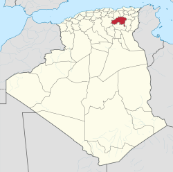
 Map of Algeria highlighting Batna | |
| 北緯35度47分 東経06度03分 / 北緯35.783度 東経6.050度座標: 北緯35度47分 東経06度03分 / 北緯35.783度 東経6.050度 | |
| 国 |
|
| 県都 | バトナ |
| 面積 | |
| • 合計 | 12,192 km2 |
| 人口 (2008)[1] | |
| • 合計 | 1,128,030人 |
| • 密度 | 93人/km2 |
| 等時帯 | UTC+01 (CET) |
| 市外局番 | +213 (0) 33 |
| ISO 3166コード | DZ-05 |
| 郡 | 22 |
| 基礎自治体 | 61 |
| ウェブサイト | Wilaya-batna.gov.dz |
バトナ県 (アラビア語: ولاية باتنة)は、アルジェリアの県(ウィラーヤ)。県都はバトナ。県内にはほかにBarika、Merouana、Timgadといった都市がある。Belezma国立公園はバトナ県にある。羊の遊牧が行われ、ベルベル人が多く居住する[2]。
行政区画
[編集]バトナ県には22の郡と61の基礎自治体がある。
郡:
基礎自治体:
- Aïn Djasser
- Aïn Touta
- Aïn Yagout
- Amantan
- Amdoukal
- Arris
- Barika
- バトナ
- Ben Foudhala El Hakania
- Bitam
- Boulhilat
- Boumague
- Boumia
- Bouzina
- Djerma
- Djezzar
- Draa Etine
- El Hassi
- El Madher
- Fesdis
- Foum Toub
- Ghassira
- Chemora
- Gosbat
- Guigba
- Hayat
- Hidoussa
- Ichmoul
- Inoughissen
- Kimmel
- Ksar Bellezma
- Larbaâ
- Lazrou
- Lemsane
- Mâafa
- Menâa
- Merouana
- Metkaouak
- N'Gaous
- Nouader
- Oued Chaâba
- Oued El Ma
- Oued Taga
- Ouled Ammar
- Ouled Aouf
- Ouled Fadel
- Ouled Sellam
- Ouled Si Slimane
- Ouyoun El Assafir
- Rahbat
- Ras Ei Aioun
- Sefiane
- Seggana
- Seriana
- Talkhamt
- Taxlent
- Tazoult
- Teniet El Abed
- Tighanimine
- Tigherghar
- Tilatou
- Timgad
- Tkout
- Zana El Beida
脚注
[編集]- ^ Office National des Statistiques, Recensement General de la Population et de l’Habitat 2008 Archived 2009年7月10日, at the Wayback Machine.2008年人口調査データ。2008-07-02閲覧(リンク切れ)
- ^ 『コンサイス外国地名事典』第3版(三省堂編修所編, 三省堂, 1998年4月)、735頁