Eilat
The "Scots" that wis uised in this airticle wis written bi a body that haesna a guid grip on the leid. Please mak this airticle mair better gin ye can. (Dizember 2020) |
Eilat
| |
|---|---|
 | |
| Coordinates: 29°33′N 34°57′E / 29.550°N 34.950°ECoordinates: 29°33′N 34°57′E / 29.550°N 34.950°E | |
| Destrict | Soothren |
| Foondit | 1951 |
| Govrenment | |
| • Teep | (frae 1959) |
| • Head of Municipality | Meir Yitzhak Halevi |
| Area | |
| • Total | 84.789 km2 (32.737 sq mi) |
| Population (2015)[1] | |
| • Total | 49,734 |
| • Density | 590/km2 (1,500/sq mi) |
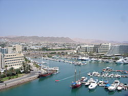
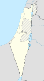
Eilat (Hebrew: אֵילַת, Arabic: إيلات ![]() (audio) (help·info)) is Israel's soothmaist ceity, a busy port as well as a popular resort, locatit at the northren tip o the Red Sea, on the Gulf o Eilat (or Gulf o Aqaba). Hame tae 49,734 fowk,[2] the ceity is pairt o the Soothren Negev Desert, at the soothren end o the Arava. The ceity is adjacent tae the Egyptian veelage o Taba tae the sooth, the Jordanian port ceity o Aqaba tae the east, an athin sicht o Saudi Arabie tae the sooth-east, athort the gulf. Eilat's arid desert climate is moderatit bi proximity tae a warm sea. Temperaturs aften exceed 40 °C (104 °F) in simmer, an 21 °C (70 °F) in winter, while watter temperaturs range atween 20 an 26 °C (68 an 79 °F). The ceity's beaches, nichtlife an desert landscapes mak it a popular destination for domestic an internaitional tourism.
(audio) (help·info)) is Israel's soothmaist ceity, a busy port as well as a popular resort, locatit at the northren tip o the Red Sea, on the Gulf o Eilat (or Gulf o Aqaba). Hame tae 49,734 fowk,[2] the ceity is pairt o the Soothren Negev Desert, at the soothren end o the Arava. The ceity is adjacent tae the Egyptian veelage o Taba tae the sooth, the Jordanian port ceity o Aqaba tae the east, an athin sicht o Saudi Arabie tae the sooth-east, athort the gulf. Eilat's arid desert climate is moderatit bi proximity tae a warm sea. Temperaturs aften exceed 40 °C (104 °F) in simmer, an 21 °C (70 °F) in winter, while watter temperaturs range atween 20 an 26 °C (68 an 79 °F). The ceity's beaches, nichtlife an desert landscapes mak it a popular destination for domestic an internaitional tourism.
Geography
[eedit | eedit soorce]
The geology an landscape are varied: igneous an metamorphic rocks, sandstane an limestane; muntains up tae 892 metres (2,927 ft) abuin sea level; broad valleys such as the Arava, an seashore on the Gulf o Aqaba. With an annual average rainfaw o 28 millimetres (1.1 in) an simmer temperaturs o 40 °C (104 °F) an heicher, watter resoorces an vegetation are leemitit. The main elements that influenced the region's history wur the copper resoorces an ither minerals, the auncient internaitional roads that crossed the aurie, an its geopoleetical an strategic position. These resultit in a settlement density that defies the environmental conditions.[3]
Neighborhuids
[eedit | eedit soorce]Eilat haes 15 neighborhuids:
- Arava
- Ganim A
- Ganim B
- Hadekel
- Ha'eshel
- Mizpe Yam
- Maar'av Sheva, kent as West7 an aw
- Neve Midbar
- Ophir
- Shahamon
- Tse'elim
- Urim
- Ye'elim
- Zofit Elite
- Zofit Tachtit
Sister ceeties an twin touns
[eedit | eedit soorce]
 Antibes, Fraunce[4]
 Juan-les-Pins, Fraunce[4]
 Arica, Chile[5]
 Durban, Sooth Africae[6]
 Serres, Greece
 Smolyan, Bulgarie[7]
 Kamen, Germany[8]
 Kampen, Netherlands
 Toronto, Canadae[4]
 Los Angeles, Unitit States[4]
 Ushuaia, Argentinae[4]
 Piešťany, Slovakie
 Sopron, Hungary
 Benidorm, Spain
Eilat haes streets named efter Durban, Kamen, Kampen an Los Angeles as well as a Canadae Pairk.
References
[eedit | eedit soorce]- ↑ "List of localities, in Alphabetical order" (PDF). Israel Central Bureau of Statistics. Retrieved 16 October 2016.
- ↑ "Table 3 - Population of Localities Numbering Above 1,000 Residents and Other Rural Population" (PDF). Israel Central Bureau of Statistics. 30 Juin 2008. Retrieved 18 October 2008.
- ↑ Avner, U. 2008. Eilat Region. In, A. Stern (ed.). The New Encyclopedia of Archaeological Excavation in the Holy Land, Volume 5 (Supplementary). Jerusalem. 1704-1711.
- ↑ a b c d e "Eilat Sister Cities". Israel-Times.com. 7 November 2007. Archived frae the original on 13 Julie 2011. Retrieved 16 December 2007.
- ↑ "What we do: Humanitarian Aid". Israel MFA. Retrieved 16 December 2007.
- ↑ "Facts about Durban". 7 September 2003. Retrieved 16 December 2007.
- ↑ "Municipal Smolyan". Retrieved 16 December 2007.
- ↑ "Weiterführende Informationen: Städtepartnerschaften". Israel MFA. Retrieved 16 December 2007.
| This Israel-relatit airticle is a stub. Ye can help Wikipaedia bi expandin it. |

