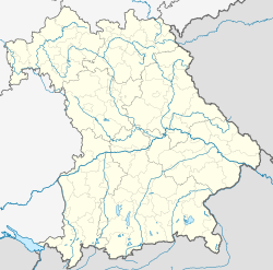
Baiern
Appearance
Baiern | |
|---|---|
 Community Berganger in Baiern | |
| Coordinates: 47°57′N 11°54′E / 47.950°N 11.900°E | |
| Country | Germany |
| State | Bavaria |
| Admin. region | Oberbayern |
| District | Ebersberg |
| Municipal assoc. | Glonn |
| Government | |
| • Mayor (2018–24) | Martin Riedl[1] |
| Area | |
| • Total | 19.96 km2 (7.71 sq mi) |
| Elevation | 590 m (1,940 ft) |
| Population (2022-12-31)[2] | |
| • Total | 1,531 |
| • Density | 77/km2 (200/sq mi) |
| Time zone | UTC+01:00 (CET) |
| • Summer (DST) | UTC+02:00 (CEST) |
| Postal codes | 85625 |
| Dialling codes | 08093 |
| Vehicle registration | EBE |
| Website | www.glonn.de |
Baiern is a community in the district of Ebersberg, Upper Bavaria, Germany. It is a member of the administrative community (Verwaltungsgemeinschaft) of Glonn.
The community's name is pronounced the same way as the German name for Bavaria ("Bayern"), although it is spelt differently. This is most likely originated from the old way of spelling Bavaria in German ("Baiern").
The constituent communities of Antholing, Berganger and Netterndorf are to be found within Baiern, as is the Jugenddorf Piusheim ("Youth Village of Piusheim").
Geography
[change | change source]Baiern is in the Munich region. It includes one traditional rural land unit – Gemarkung in German – also called Baiern.
References
[change | change source]- ↑ Liste der ersten Bürgermeister/Oberbürgermeister in kreisangehörigen Gemeinden, Bayerisches Landesamt für Statistik, accessed 19 July 2021.
- ↑ Genesis Online-Datenbank des Bayerischen Landesamtes für Statistik Tabelle 12411-003r Fortschreibung des Bevölkerungsstandes: Gemeinden, Stichtag (Einwohnerzahlen auf Grundlage des Zensus 2011) .


