Los Ríos Region
Los Ríos Region
Región de Los Ríos | |
|---|---|
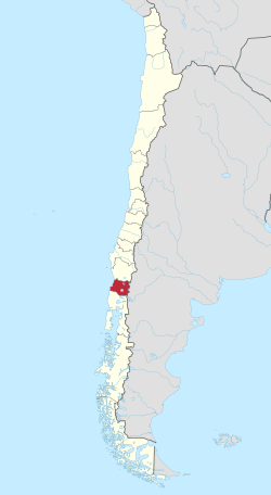
 Map of Los Ríos Region | |
| Coordinates: 39°48′30″S 73°14′30″W / 39.80833°S 73.24167°W | |
| Country | |
| Capital | Valdivia |
| Provinces | Valdivia, Ranco |
| Government | |
| • Intendant | César Asenjo (UDI) |
| Area | |
| • Total | 18,429.5 km2 (7,115.7 sq mi) |
| • Rank | 11 |
| Highest elevation | 2,236 m (7,336 ft) |
| Lowest elevation | 0 m (0 ft) |
| Population (2017 census)[1] | |
| • Total | 380,181 |
| • Rank | 11 |
| • Density | 21/km2 (53/sq mi) |
| ISO 3166 code | CL-LR |
| HDI (2019) | 0.795[2] high |
| Website | Official website |
The XIV Los Ríos Region (Spanish: Región de Los Ríos, Region of the Rivers) is one of Chile's 15 first order administrative divisions. Its capital and largest city is Valdivia.
It began to operate as a region on 2007, having been created by subdividing the Los Lagos Region in southern Chile. It consists of two provinces: Valdivia and the new El Ranco province, that was part of the Valdivia province.
Geography
[change | change source]The Los Ríos region has an area of 18,429.5 km2 (7,115.7 sq mi).[3]
It borders the La Araucanía region to the north, Argentina to the east, the Los Lagos region to the south and the Pacific Ocean on the west.[3]
The two main rivers in the region are the Valdivia river, in the northern part of the region, and the Bueno river, in the southern part of the region.
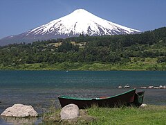
The highest mountain in the region is the Villarrica volcano (Spanish: Volcán Villarrica) (39°25′15″S 71°56′22″W / 39.42083°S 71.93944°W), 2,860 m (9,380 ft) high, near the border with Argentina.[4]
Population
[change | change source]The Los Ríos had a population of 356,396 inhabitants (2002 census) and its population density was 19.3.
The largest city in the region is its capital, Valdivia, with 127,750 inhabitants (2002 census). The other provincial capital, La Unión had 25,615 inhabitants.
Administration
[change | change source]The Los Ríos region is further subdivided into two provinces: Valdivia and El Ranco.
| Province | Capital | Code | Comuna | Area[3] (km²) |
Population[3] (2002) |
|---|---|---|---|---|---|
| Valdivia (141) | Valdivia | 14101 | Valdivia | 1,015.6 | 140,559 |
| 14102 | Corral | 766.7 | 5,463 | ||
| 14103 | Lanco | 532.4 | 15,107 | ||
| 14104 | Los Lagos | 1,791.2 | 20,168 | ||
| 14105 | Máfil | 582.7 | 7,213 | ||
| 14106 | Mariquina | 1,320.5 | 18,223 | ||
| 14107 | Paillaco | 896.0 | 19,237 | ||
| 14108 | Panguipulli | 3,292.1 | 33,273 | ||
| Total of Valdivia province | 10,197.2 | 259,243 | |||
| El Ranco (142) | La Unión | 14201 | La Unión | 2,136.7 | 39,447 |
| 14202 | Futrono | 2,120.6 | 14,981 | ||
| 14203 | Lago Ranco | 1,763.3 | 10,098 | ||
| 14204 | Río Bueno | 2,211.7 | 32,327 | ||
| Total of El Ranco province | 8,232.3 | 97,153 | |||
| Total of the region | 18,429.5 | 356,396 | |||
Gallery
[change | change source]Related pages
[change | change source]References
[change | change source]- ↑ 1.0 1.1 "Los Ríos Region". Government of Chile Foreign Investment Committee. Retrieved 13 March 2010.[permanent dead link]
- ↑ "Sub-national HDI - Area Database - Global Data Lab". hdi.globaldatalab.org. Retrieved 26 October 2021.
- ↑ 3.0 3.1 3.2 3.3 "Región de Los Ríos" (PDF). Instituto Nacional de Estadísticas. 2007. Archived from the original (PDF) on 20 May 2017. Retrieved 13 September 2017.
- ↑ "Volcán Villarrica, Chile". Peakbagger.com. Retrieved 14 September 2017.
Other websites
[change | change source] Media related to Los Ríos Region at Wikimedia Commons
- Gobierno Regional de Los Ríos Archived 2013-12-04 at the Wayback Machine Official website (in Spanish)
| Regions of Chile | |
|---|---|
| Arica y Parinacota | Tarapacá | Antofagasta | Atacama | Coquimbo | Valparaíso | O'Higgins | Maule | Ñuble | Bío Bío | La Araucanía | Los Ríos | Los Lagos | Aysén | Magallanes y la Antártica Chilena | RM Santiago | |


