Medway
Appearance
Medway | |
|---|---|
|
Clockwise from top: Rochester Cathedral, HMS Ocelot, Rochester Castle, Royal Engineers Museum, Upnor Castle, Chatham Historic Dockyard | |
|
Official logo of Medway Council logo | |
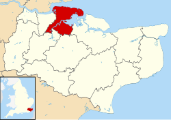
 Shown within Kent | |
| Coordinates: 51°23′N 0°32′E / 51.39°N 0.54°E | |
| Sovereign state | United Kingdom |
| Constituent country | England |
| Region | South East England |
| Ceremonial county | Kent |
| Status | Unitary authority |
| Incorporated | 1 April 1998 |
| Admin HQ | Gun Wharf, Chatham |
| Government | |
| • Type | Unitary authority |
| • Body | Medway Council |
| • Leadership | Leader & Cabinet (Labour Co-op) |
| • Mayor | Cllr Marian Nestorov |
| • MPs | |
| • Deputy Mayor | Cllr Douglas Hamandishe |
| • Council Leader | Cllr Vince Maple |
| Area | |
| • Total | 74.14 sq mi (192.03 km2) |
| • Rank | 170th (of 326) |
| Population (2022) | |
| • Total | 278,500 |
| • Rank | 47th (of 326) |
| • Density | 3,800/sq mi (1,500/km2) |
| Ethnicity (2021) | |
| • Ethnic groups | |
| Religion (2021) | |
| • Religion | List
|
| Time zone | UTC0 (GMT) |
| • Summer (DST) | UTC+1 (BST) |
| ONS code | 00LC (ONS) E06000035 (GSS) |
| OS grid reference | TQ768688 |
| Website | medway |
Medway (commonly called the Medway Towns) is a large urban area in North Kent. It is made up of 5 towns: Strood, Rochester, Chatham, Gillingham and Rainham. It is named after the River Medway. As of 2019 it has 278,016 people.[2]
References
[change | change source]- ↑ 1.0 1.1 UK Census (2021). "2021 Census Area Profile – Medway Local Authority (E06000035)". Nomis. Office for National Statistics. Retrieved 5 January 2024.
- ↑ "Medway population projection" (PDF). Medway.gov.uk. Archived from the original (PDF) on 13 November 2012. Retrieved 16 December 2013.
Other websites
[change | change source]![]() Media related to Medway at Wikimedia Commons
Media related to Medway at Wikimedia Commons


