Pastetten
Appearance
Pastetten | |
|---|---|
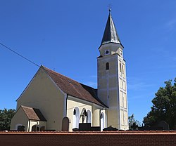
 Church of Saint Martin | |
| Coordinates: 48°12′N 11°57′E / 48.200°N 11.950°E | |
| Country | Germany |
| State | Bavaria |
| Admin. region | Oberbayern |
| District | Erding |
| Municipal assoc. | Pastetten |
| Government | |
| • Mayor (2020–26) | Peter Deischl[1] |
| Area | |
| • Total | 22.05 km2 (8.51 sq mi) |
| Highest elevation | 558 m (1,831 ft) |
| Lowest elevation | 508 m (1,667 ft) |
| Population (2022-12-31)[2] | |
| • Total | 2,878 |
| • Density | 130/km2 (340/sq mi) |
| Time zone | UTC+01:00 (CET) |
| • Summer (DST) | UTC+02:00 (CEST) |
| Postal codes | 85669 |
| Dialling codes | 08124 |
| Vehicle registration | ED |
| Website | www.pastetten.de |
Pastetten is a municipality in the district of Erding in Bavaria in Germany. It is a rural municipality in the south of the district. The town was founded about one thousand years ago along the road from Swabia to Erding.[3]
References
[change | change source]- ↑ Liste der ersten Bürgermeister/Oberbürgermeister in kreisangehörigen Gemeinden, Bayerisches Landesamt für Statistik, 15 July 2021.
- ↑ Genesis Online-Datenbank des Bayerischen Landesamtes für Statistik Tabelle 12411-003r Fortschreibung des Bevölkerungsstandes: Gemeinden, Stichtag (Einwohnerzahlen auf Grundlage des Zensus 2011) .
- ↑ 'Gemeinde Pastetten', VG Pastetten, 2007 Archived 2007-03-02 at the Wayback Machine. Retrieved [2 June] 2007.
Other websites
[change | change source]- Official website
 (in German)


