Porte-de-Benauge
Appearance
Porte-de-Benauge | |
|---|---|
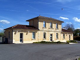
 The town hall in Arbis | |
| Coordinates: 44°40′46″N 0°14′41″W / 44.6794°N 0.2447°W | |
| Country | France |
| Region | Nouvelle-Aquitaine |
| Department | Gironde |
| Arrondissement | Langon |
| Canton | L'Entre-Deux-Mers |
| Intercommunality | Rurales de l'Entre-Deux-Mers |
| Government | |
| • Mayor (2019–2020) | Eric Guérin |
| Area 1 | 16.74 km2 (6.46 sq mi) |
| Population (Jan. 2019)[1] | 489 |
| • Density | 29/km2 (76/sq mi) |
| Time zone | UTC+01:00 (CET) |
| • Summer (DST) | UTC+02:00 (CEST) |
| INSEE/Postal code | 33008 /33760 |
| Elevation | 23–107 m (75–351 ft) |
| 1 French Land Register data, which excludes lakes, ponds, glaciers > 1 km2 (0.386 sq mi or 247 acres) and river estuaries. | |
Porte-de-Benauge is a commune. It is found in the region Nouvelle-Aquitaine in the Gironde department in the southwest of France. The municipality was created on 1 January 2019 and consists of the former communes of Arbis (the seat) and Cantois.[2]
References
[change | change source]- ↑ "Populations légales 2019". The National Institute of Statistics and Economic Studies. 29 December 2021.
- ↑ Arrêté préfectoral 28 September 2018 (in French)


