Shade maps for climatically-aware urban design in Tel Aviv-Yafo
 Or Aleksandrowicz
2018, Proceedings of Cyprus Network of Urban Morphology_1st Regional Conference
Tel Aviv is a coastal city of hot and humid climate, exposed to relatively high levels of solar radiation. Such climatic conditions make direct solar radiation a crucial element that negatively affects outdoor thermal comfort between April and October and thus the use of streets and public spaces for a variety of outdoor activities (Shashua-Bar et al., 2009; Shashua-Bar et al., 2011; Hiemstra et al., 2017). Our study, commissioned by Tel Aviv-Yafo Municipality, developed a new methodology for the evaluation of microclimatic conditions across the city, focusing on the provision of outdoor shade as a central component of urban design. Based on an urbanscale 2.5D GIS mapping of buildings, ground surfaces, and tree canopies, we employed a high-resolution calculation of solar exposure of streets and open spaces (public and private) covering the entire city. The calculation produced a comprehensive "shade map" for Tel Aviv-Yafo, showing the cumulative daily exposure to solar radiation at ground level during summer. Analysis of the shade maps enabled to relate building and tree morphologies to outdoor shading on both district and street levels, unfolding a "hierarchy of shade" across the city. For prioritizing the intervention of local planning authorities in improving poor shade conditions or conserving effectively-shaded locations, we then employed space syntax analysis techniques. The spatial analysis produced a classification of streets and urban hot spots according to their potential pedestrian attraction. By juxtaposing the climatic and spatial analyses, we were able to provide the Municipality with recommendations for targeted intensification of shade in locations where the discrepancy between pedestrian movement and lack of shade was the most pronounced. At the same time, we were also able to identify exemplary, well-shaded central streets and open spaces, thus enabling the municipality planners to initiate a "shade conservation" program for the entire city.
Sign up for access to the world's latest research
Figures (4)


Introduction
Tel Aviv-Yafo is a Mediterranean coastal city of hot and humid climate, exposed to relatively high levels of solar radiation (about 3300 annual sun hours, average daily solar insolation of 5 kWh/m2). In recent years, the city's urban area has been going through rapid development and expansion that is believed to continue in an increasing rate. Unless managed properly, this process may exacerbate the climatic conditions in the city, and especially the tendency of air temperatures in streets and open spaces to rise much above temperature levels outside the urban area. The magnitude of this phenomenon, which is sometimes referred to as the "urban heat island" (UHI), results from the physical configuration of the city (its topography, spatial morphology, building density, and open space configuration), as well as the materials used for the construction of buildings, pavements, and roads, the flow of air through the street network, and human activities such as transportation and industry (Santamouris, 2001;Gartland, 2008;Erell et al., 2011).
The overheating of urban streets and open spaces, which has been long documented also in Tel Aviv (Saaroni et al., 2000;Sofer & Potchter, 2005;Rotem-Mindali et al., 2015), has many negative effects, including higher outdoor thermal discomfort rates during the hot season, increased heat stress and morbidity and mortality rates, and deteriorated air quality (Kleerekoper et al., 2012). Climate change is expected to worsen all these effects. While the rise in air temperatures has certainly a negative effect on microclimatic conditions during the hot season, in Tel Aviv-Yafo (as well as in other cities of similar climate) the streets' exposure to direct solar radiation has a much more significant impact on daytime outdoor thermal comfort than air temperatures, at least between the beginning of April and the end of October (Shashua- Bar et al., 2009;Shashua-Bar et al., 2011;Hiemstra et al., 2017). This highlights the importance of shade provision in streets and open public spaces, since shade-oriented urban design is expected to result in a substantial lowering of outdoor thermal discomfort. This paper reports on an attempt, a first of its kind, for evaluating the microclimatic conditions in Tel Aviv-Yafo by focusing on the provision of outdoor shade as a central component of urban design. Based on an urban-scale 2.5D GIS (Geographic Information System) mapping of buildings, ground surfaces, and tree canopies, we applied a high-resolution calculation of solar exposure of streets and open spaces (public and private) to the entire city. This type of calculation enabled to produce shade maps for the entire city, and thus to better understand the interrelations between street morphology, tree cover, and shade provision. By combining the detailed mapping of shade with spatial analysis of the city's street network, we were also able to prioritize municipal action for intensifying and conserving shade, thus providing city planners with a practical tool for employing concrete policies for climatically-aware urban design.
Methodology
The creation of a high-resolution shade map for an entire city depends on the quality of geographic data available for analysis. When proper mapping of terrain, building roofs, and tree canopies exists, a GIS-based calculation module can be employed to automatically calculate the cumulative amount of solar radiation received by horizontal surfaces during a given time frame; in our study, we used the Area Solar Radiation function in ArcMap (ESRI, 2017) to produce the shade maps that were used for analysis. In ArcMap, the production of such a map is based on a single raster layer of a geo-referenced Digital Surface Model (DSM). Users are asked to provide latitude details, calculation dates, and calculation intervals (how many times during the given time frame a calculation is executed; the lower the interval, the higher is the calculation's accuracy). Compared to current simulation tools of urban microclimate, this calculation method is highly efficient in the use of computer resources: in our study, the calculation of a city-wide shade map (resolution of 0.5 m per pixel) for an area of about 52 square km took 72 hours of continuous calculation on a single Intel core i5 computer.
We produced shade maps based on two separate DSMs, one that contains the heights of the terrain, building roofs, and tree canopies, and the other composed only of terrain and building roofs heights. This division enabled to evaluate the partial contribution of tree canopies to the provision of outdoor shade. While using a "tree-free" DSM with the Area Solar Radiation function is quite straightforward, the inclusion of tree canopies presents a challenge. The algorithm calculates solar radiation levels on horizontal surfaces: pavements, roads, building roofs, but also tree canopies. Since we were interested in street-level solar exposure, we thus could not use the results as they were, since the algorithm did not calculate solar radiation under the tree canopies but rather straight on them. Therefore, and for the sake of simplification, we assumed that exposure levels right under the tree canopies (in the area under the canopy's horizontal projection) equals zero, though in actual conditions the value is slightly higher because of the changing solar incidence angles during the day. While this simplification slightly underestimates street-level solar exposure, it was essential for producing a comprehensive analysis for the entire urban area of Tel Aviv-Yafo in a reasonable calculation time.
The geographic data we received from the Tel Aviv-Yafo municipality was a shapefile of all building roofs in the city (updated to the year 2009), as well as a Digital Terrain Model (DTM) in a resolution of 10 m per pixel. Based on these files, we created a combined DSM (terrain and building roof heightmap) in a 0.5 m per pixel resolution. Since a tree canopy heightmap for Tel Aviv-Yafo is still unavailable, we used a current orthophoto of the city, processed it through the image classification tools available in ArcMap, and then manually tweaked the processed raster file to accurately trace all tree canopies on a resolution of 0.5 m per pixel. This method has an inherent inaccuracy in respect to canopy height: since the traditional photogrammetric methods of calculating canopy height from orthophotos is highly resource-intensive, we decided to assume that all tree canopies in the city end 6 m above ground, which corresponds well to the local tree pruning policy.
Based on these data sets, we produced two shade maps (with and without calculating the effect of tree canopies) for the entire city of Tel Aviv-Yafo. The maps showed the cumulative solar insolation of horizontal surfaces during several key dates that cover the summer period: 21 June (northern hemisphere summer solstice), 21 September (equinox), and 6 August (halfway between 21 June and 21 September). Calculation was executed in intervals of 0.5 hour during the entire 24hour period. These maps were then statistically analysed in ArcMap on the district and street segment levels.
The first part of analysing the results was a district-level analysis. We based the analysis on a division of the urban area to 125 spatially and morphologically-distinct zones. For each zone, we calculated the following variables:
1. Average Urban Shade (AUS) index: the value of 1 minus the ratio between the average solar radiation received at ground level in the entire zone and the maximum average solar insolation of the same area. The higher the AUS value, the higher is the amount of direct solar radiation deflected without reaching the ground.
2. Urban Tree Cover (UTC) index: the ratio between the horizontal projection of all canopies in a zone and the zone's total area. The higher the value, the higher is the tree cover.
3. Urban Tree Shade Efficacy (UTSE) index: weighting a zone's AUS value by the UTC value (AUS UTC ) in a way that gives indication for the efficient use of trees in the provision of shade. The higher the value, the more efficient is the use of trees for shading. A zone that highly relies on trees for street level shading is deemed less efficient in its use of trees, since it does not exploit well the potential of street shading by buildings. In other words, low efficacy represents a higher "price" of shade, resulting from the costs of maintaining the urban forest (planting, watering, pruning, etc.).
The second part of the statistical analysis focused on shading provision in street segments (a single street segment is a part of a street extending between two intersections). Based on a shapefile of the city's streets received from the Tel Aviv-Yafo municipality, we first manually divided all the city's streets into distinct segments, and then filtered the city-scale shade maps to include only solar radiation values in those segments (in the original shade maps there was no distinction between streets and privately-owned open areas). For each street segment in the city, we then calculated the average cumulative daily solar exposure (on the pavements and road). In addition, for each street segment we calculated two variables:
1. Average Street Segment Shade (ASSS) index: the value of 1 minus the ratio between the calculated amount of solar radiation received at street level and the maximum solar insolation of the entire street segment area (pavements and road). The higher the ASSS value, the higher is the amount of direct solar radiation deflected without reaching the ground.
2. Street Tree Cover (STC) index: the ratio between the horizontal projection of all tree canopies in a street segment and the segment's total area. The higher the value, the higher is the tree cover.
While street segment analysis can reveal how many street segments substantially lack shade, when the number of these segments is high, it is of little help for planners who wish to adopt a comprehensive intervention strategy on street shade enhancement. The problem lies in the limited financial means that can be allocated for intensifying or conserving shade (through trees or artificial shading structures alike): with no structured method for grading the need for intervention, it is hard to determine which street segments require intervention more than others.
While it is possible to grade the need for shade based only on the ASSS index (the lower the value, the higher is the need), this type of grading makes almost no sense when a large number of street segments suffer from substantial lack of shade (for example, according to our analysis, in Tel Aviv-Yafo the ASSS index of more than 1,450 street segments is less than 0.2). Spatial analysis, however, can be applied to overcome the limitations of solar analysis, through the creation of a grading system that is based on the centrality of certain street segments. This method enabled us to produce a clear hierarchy for intervention.
The spatial analysis method that was adopted in this study followed the configurational approach, which enables to reveal inherent patterns of centrality in an urban street network, through the application of the space syntax methodology of spatial analysis. Space syntax indices were proven in numerous studies to be associated with diverse urban phenomena and especially with pedestrian movement and viability of urban centres (Hillier, 1996;Karimi, 2012;Lerman et al., 2014). One of the central concepts of space syntax is the integration index, which describes the centrality of a certain street segment relative to the analysed street network. This index can be calculated for the entire network or only for parts of it (limited by a certain metric radius), reflecting regional and local computations.
Studies on pedestrian movement patterns have found a relatively high correlation between actual movement and the integration index at radii of 1,000 to 2,000 m in Israeli cities (Lerman et al., 2014;Lerman & Lebendiger, 2017). Other studies have found that an integration index at a regional radius of 7,500 m can be associated with conurbation centralities and the creation of regional business districts (Serra & Pinho, 2013).
In this study, the spatial analysis was used to calculate centrality (integration) indices at local and regional scales to evaluate the probability of pedestrian movement to pass through each street segment and to locate central business districts, where a relatively high pedestrian movement of office workers is likely to occur during daytime. The potential for local movement was deduced from integration indices at 8 different radii: 250 m, 500 m, 750 m, 1,000 m, 1,250 m, 1,500 m, 1,750 m, and 2,000 m. The potential for regional agglomerations was deduced from integration indices at 6 different radii: 2,500 m, 3,000 m, 4,000 m, 5,000 m, 6,000 m, and 7,500 m. The space syntax indices calculations were performed using depthmapX software (Varoudis, 2014).
Following the calculation of the integration values, a spatial "prominence score" was calculated for each street segment. This value, calculated separately for the local and regional levels of analysis, reflected the relative centrality of each segment in the entire urban network. When the integration value of a segment in a certain radius was in the upper quintile of integration values of all segments, the segment received one "prominence" point. For local movement, a maximum "prominence score" was therefore a value of 8 (reflecting the integration value at 8 local radii), and for regional movements -6 (reflecting the integration value at 6 regional radii). The higher the score, the higher is the segment's centrality at the local and regional levels. Based on this calculation method, two maps of pedestrian movement potentials (local and regional) were created, showing only the segments that received a "prominence score" greater than 2.
In the last stage of analysis, segments appearing in the movement potential maps were filtered according to their ASSS values. We used two filtering thresholds:
1. Street segments where ASSS values are below 0.2.
2. Street segments where ASSS values are above 0.6.
The filtering process created two new shade maps: the first showing the city's most central street segments that require shade intensification, the second showing the most central street segments in which shade levels should be protected (what can be described as streets designated for "shade conservation"). This filtering process thus highlighted a limited set of street segments that require the immediate intervention of the planning authorities. The degree of importance among the highlighted segments was reflected by the segment's "prominence score" and not by its ASSS value.
Results
After analysing the raw shade maps of the three calculated dates, it was evident that in terms of urban shade values there is only a small difference between the results produced for 21 June (summer solstice) and 6 August. In terms of the daily sun path and solar insolation, 6 August is also similar to 6 May. Therefore, it can be argued that the results of 6 August, which were used for further analysis, give a good indication for the microclimatic conditions during a longer period, which extends from May to August and covers the main months of extreme summer conditions.
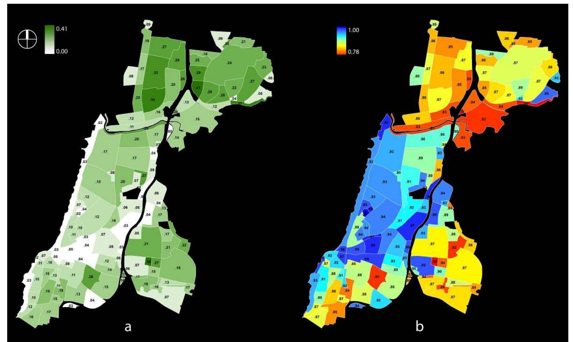
Urban shade analysis on the district level ( Figure 1a) showed a clear distinction between different parts of the city. Tel Aviv-Yafo's historic core, whose layout and parcellation dates mainly to the 1920s, 1930s, and 1940s, showed a relative high AUS values of 0.52-0.64. The part of the historic core that is referred to as "Geddes Plan", which was mainly built during the 1930s and 1940s according to a masterplan conceived by Patrick Geddes, showed almost the highest AUS value (0.64) in the entire city. Many of the zones in the southern part of the city showed much lower AUS values (between 0.3 and 0.48). In a sharp contrast, the northern parts of the city showed much higher AUS values (0.53-0.67). Some of the lowest AUS values were calculated in the main city parks, reflecting their design as vast grass-covered open spaces with only a small number of trees.
Figure 1
Average Urban Shade (AUS) index for 6 August of morphologically-uniform zones in Tel Aviv-Yafo, including (a) and excluding (b) the shading effect of trees Figure 2. a) Urban Tree Cover (UTC) index of morphologically-uniform zones in Tel Aviv-Yafo; b) Urban Tree Shade Efficacy (UTSE) index for 6 August of the same zones
Comparison of these results with the shade map that was produced without calculating the effect of trees (Figure 1b) and to the urban tree canopy map (Figure 2a) showed that the reason for the discrepancy between the AUS values of the northern and southern parts of the city mainly lies in the substantially higher tree cover ratio of the northern parts. Interestingly, the historic core of the city produced much higher AUS values while maintaining a similar tree cover as that of the southern parts. This result should be attributed to the relatively dense urban fabric of the historic core (in terms of total floor to zone area ratio), which is much different from that of the less dense northern and southern parts of the city. In terms of the tree efficacy index (UTSE, Figure 2b), the results showed that the historic core makes the most efficient use of its tree cover, since it combines it with a relatively dense built urban fabric, while the northern neighbourhoods, where tree cover is high and building density is relatively low, are the worst performing districts in terms of tree cover efficacy. Results of the street segments analysis largely support the general conclusions of the district-level results (Figure 3a). Many of the streets in the historic core, and especially in the area of Geddes Plan, are relatively well shaded, as well as streets in some of the neighbourhoods in northern Tel Aviv-Yafo. Street orientation also has a clear effect on street-level solar exposure: streets aligned to the north-south axis are relatively better shaded than streets aligned to the east-west axis. This effect is a result of the typical characteristics of the sun path during summer (low solar angle from the east and west, high solar angle from the south), and is largely attributed to shading from buildings. However, in streets aligned to the east-west axis, a dense array of trees can keep solar exposure levels relatively low, as some of the streets in the historic core show. At the same time, it should be noted that almost all the city's main shopping streets and roads are highly exposed to solar radiation, in parts because of relatively low levels of STC (below 20%). Figure 3. a) Street segments in Tel Aviv-Yafo with Average Street Segment Shade (ASSS) index below 0.2 and above 0.6 for 6 August; b) Locally highly-integrated street segments in Tel Aviv-Yafo with a prominence score greater than 2; c) Regionally highly-integrated street segments in Tel Aviv-Yafo with a prominence score greater than 2 The spatial analysis that was applied to the street network of Tel Aviv-Yafo revealed two distinct centrality regimes in the city (Figures 3b and 3c). The most locally integrated zones, where probably the most walkable streets are located, are those of the historic cores of Tel Aviv and Yafo (Jaffa). The most regionally integrated segments are located in the arterial roads of Tel Aviv and in the new Central Business District on the eastern edge of the historic core. While several of these roads are major motorized roads, others have the potential to become major pedestrian thoroughfares catering to different types of road users.
Figure 2
Figure 3
Combining the results of average solar exposure in street segments and the spatial analysis produced maps that highlighted streets with acute lack of summer shade or exemplary levels of summer shade provision (Figure 4a). Interestingly, the number of exemplary shaded street segments was small; most of them were located within the historic core of the city in streets rich in tree cover ( Figure 4b). As for the lack of shade, the combined map highlighted several long streets outside the historic core (especially in the southern part of the city) as being relatively central but highly deficient in shade provision. A bit surprising was the considerable number of central northsouth streets that were highlighted as deficient; this can be attributed to the lack of densely built urban fabric along these streets, in addition to a substantial lack of tree cover ( Figure 4b).
Figure 4
a) A combined map of Tel Aviv-Yafo showing the most central street segments that require shade intensification (red palette) and shade conservation (green palette); b) Street Tree Cover (STC) rates for all street segments in Tel Aviv-Yafo
Conclusion
In Tel Aviv-Yafo, street-level exposure to solar radiation is a key element affecting outdoor thermal comfort, much more than other climatic variables (outdoor air temperatures, relative humidity, and air flow speed). The relative impact of solar insolation of streets is such that only by calculating its magnitude we can obtain a reliable impression of outdoor comfort levels resulting from the specific characteristics of the built fabric and the urban forest. Unlike microclimatic simulation tools, which still cannot produce high-resolution results on a city scale because of their resource-intensive calculation methods, the methodology presented here is relatively simple to employ for an entire city. This is the result of the reduction of the microclimatic question to a single variable (solar exposure) whose values are affected only by the geometrical properties of the city.
This paper demonstrates the advantages of the suggested methodology in mapping a "hierarchy of shade" across an entire city. In Tel Aviv-Yafo, the analysis showed that the historic core of the city, which was built according to masterplans from the 1920s, 1930s, and 1940s, is highly efficient in combining relatively dense street morphology and trees for the production of high levels of street shade. It also showed that later masterplans failed to reproduce such conditions, and that the newer neighbourhoods of the city are highly dependent on trees for shade provision. This makes the "cost" of shade outside the historic core much higher than within it.
Another aspect of the proposed methodology is the application of spatial analysis in prioritizing actions for better microclimatic design. Thus, an "hierarchy of shade", when combined with a "spatial hierarchy" of a city, can support concrete actions by planning authorities, either in improving current conditions or in conserving some of their exemplary aspects. In Tel Aviv-Yafo, this combined method highlighted a number of central streets that required immediate action, most of them in the southern part of the city in which tree cover is much lower than in other parts of the city. It also highlighted the exemplary street design of several main streets within the historic core that may need to receive an official protection for maintaining their favourable microclimatic characteristics.
Funding
The study was funded by the Conservation Department at the Tel Aviv-Yafo municipality.