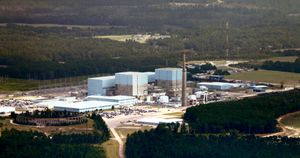
Brunswick Nuclear Generating Station
| Brunswick Nuclear Plant | |
|---|---|

Brunswick Plant
|
|
|
Location of Brunswick Nuclear Plant in North Carolina
|
|
| Country | United States |
| Location | Smithville Township, Brunswick County, near Southport, North Carolina |
| Coordinates | Lua error in package.lua at line 80: module 'strict' not found. |
| Status | Operational |
| Commission date | 1975 |
| Operator(s) | Duke Energy Progress |
| Nuclear power station | |
| Reactor type | BWR |
| Power generation | |
| Units operational | 2 × 990 MW |
| Nameplate capacity | 1,979 MW |
| Capacity factor | 85.4% |
| Annual generation | 14,811 GWh |
The Brunswick nuclear power plant, named for the county in which it is located, covers 1,200 acres (490 ha). The site is adjacent to the town of Southport, North Carolina, and to wetlands and woodlands, and was opened in 1975.
The site contains two General Electric boiling water reactors, which are cooled by water collected from the Cape Fear River and discharged into the Atlantic Ocean.
Duke Energy Progress is the majority owner (81.7%) and operator of the Brunswick nuclear plant. The North Carolina Eastern Municipal Power Agency owns the remaining 18.3%. Duke Energy Progress is currently in the process of buying The North Carolina Eastern Municipal Power Agency's 18.3% Stake at Brunswick nuclear power plant. (Duke Energy completed its merger with Progress Energy on July 2, 2012.)
The Brunswick plants' proximity to the Cape Fear River and the Atlantic Ocean allowed the designers to take in cooling water from the Cape Fear river and discharge it into the Atlantic off the coast of Oak Island. Fish, crustaceans, and other debris are removed from the cooling water via a filtration system. The water then flows through the nuclear plant and discharges into a five mile long canal which passes under the Intra-Coastal Waterway at one point.
Surrounding population
The Nuclear Regulatory Commission defines two emergency planning zones around nuclear power plants: a plume exposure pathway zone with a radius of 10 miles (16 km), concerned primarily with exposure to, and inhalation of, airborne radioactive contamination, and an ingestion pathway zone of about 50 miles (80 km), concerned primarily with ingestion of food and liquid contaminated by radioactivity.[1]
The 2010 U.S. population within 10 miles (16 km) of Brunswick was 36,413, an increase of 105.3 percent in a decade, according to an analysis of U.S. Census data for msnbc.com. The 2010 U.S. population within 50 miles (80 km) was 468,953, an increase of 39.6 percent since 2000. Cities within 50 miles include Wilmington (18 miles to city center).[2]
Seismic risk
The Nuclear Regulatory Commission's estimate of the risk each year of an earthquake intense enough to cause core damage to the reactor at Brunswick was 1 in 66,667, according to an NRC study published in August 2010.[3][4]
References
- ↑ http://www.nrc.gov/reading-rm/doc-collections/fact-sheets/emerg-plan-prep-nuc-power-bg.html
- ↑ Bill Dedman, Nuclear neighbors: Population rises near US reactors, msnbc.com, April 14, 2011 http://www.msnbc.msn.com/id/42555888/ns/us_news-life/ Accessed May 1, 2011.
- ↑ Bill Dedman, What are the odds? US nuke plants ranked by quake risk, msnbc.com, March 17, 2011 http://www.msnbc.msn.com/id/42103936/ Accessed April 19, 2011.
- ↑ http://msnbcmedia.msn.com/i/msnbc/Sections/NEWS/quake%20nrc%20risk%20estimates.pdf
External links
![]() Media related to Lua error in package.lua at line 80: module 'strict' not found. at Wikimedia Commons
Media related to Lua error in package.lua at line 80: module 'strict' not found. at Wikimedia Commons
